Port Mathurin

Last updated
Port Mathurin
Por Matirin (Morisyen)
Port Mathurin.jpg
Port Mathurin as seen from Mount Fanal
Rodrigues Zonenkarte de.png
14 Zones of Rodrigues,
with Port Mathurin due north
Coordinates: 19°41′S63°25′E / 19.683°S 63.417°E / -19.683; 63.417
CountryFlag of Mauritius.svg  Mauritius
Island Rodrigues
Population
  Total6,000
Time zone UTC+4 (MUT)
  Summer (DST) UTC+5
Climate Aw

The village of Port Mathurin serves as the capital of the island of Rodrigues, a dependency of Mauritius. Most of the population of Rodrigues is settled close to or in the city. It lies on the north coast of the Indian Ocean island and functions as the administrative, judicial and economic centre of Rodrigues. As the name suggests, it also operates the main harbour of the island.

Contents

Port Mathurin PortMathurin.JPG
Port Mathurin

Port Mathurin has a population of around 6,000 people (2006). Sights include its market, while the town also has the island's only bus station and a viewpoint on Mount Fanal, south of the town. There is a Roman Catholic church, an Anglican church, and a small mosque. Other landmarks of Port Mathurin include Marie, Queen of Rodrigues, a statue of the Virgin Mary located in Pointe Canon. The two ships of the Mauritius Cargo Handling Corporation, namely MV Mauritius Pride and Mauritius Trochetia, anchor at Port Mathurin five times every month.

On 1 May 1691, François Leguat and the first French landed on Rodrigues at the site of the future village, which was founded by French colonists in 1735. The place takes its name from that of an early French settler, either Mathurin Bréhinier or Mathurin Morlaix.

In 1901 Port Mathurin became home to offices for the Britain-Australia undersea cable.

There are 22 localities within the zone of Port Mathurin, which is one of 14 statistical subdivisions of Rodrigues, to which the population of 6,000 relates: [1]

  1. Baie Lascars (North)
  2. Camp du Roi
  3. Castor
  4. Caverne Provert
  5. Citronelle
  6. Crève Coeur
  7. Désiré
  8. English Bay
  9. Fond La Digue
  10. Jentac
  11. Mont Piton
  12. Mont Vénus
  13. Montagne Charlot
  14. Montagne Fanal
  15. Pointe Canon
  16. Pointe Monnier
  17. Port Mathurin
  18. Roseaux
  19. Solitude
  20. Soupir
  21. Terre Rouge
  22. Vangar

The village (locality) has a single secondary school: Rodrigues College. Other colleges operate in other villages around the island, namely Le Chou, Marechal, Grand Montagne, Mont Lubin and Citron Donis.

The locality of Port Mathurin proper occupies a very small area, and neighbouring settlements (localities) include Fond La Digue, Montagne Fanal, Pointe Monier, Camp du Roi and Baie Lascar.

In 1996, the Expedition yacht Admiral Nevelskoi, ended his course in the lagoon next to Port Mathurin, after 2 years voyage crewless. This yacht, which was a property of the Russian government, was then given to Hon. Bernard Eric Typhis Degtyarenko in 2010, and also declared as a Maritime Museum by the Admiral Nevelskoi Maritime University. The yacht is now one of several historic links between Russia and Mauritius. [2] It is important to emphasize that it is one of the most expensive yachts in the world in its category, including its historical importance, its value reaches more than several million dollars. [3] [4]

Climate

Climate data for Port Mathurin (1991–2020)
MonthJanFebMarAprMayJunJulAugSepOctNovDecYear
Record high °C (°F)33.0
(91.4)
34.0
(93.2)
34.1
(93.4)
32.2
(90.0)
31.2
(88.2)
29.8
(85.6)
29.4
(84.9)
28.2
(82.8)
28.5
(83.3)
29.8
(85.6)
32.1
(89.8)
32.7
(90.9)
34.1
(93.4)
Mean daily maximum °C (°F)29.9
(85.8)
30.0
(86.0)
29.9
(85.8)
29.1
(84.4)
27.8
(82.0)
26.4
(79.5)
25.4
(77.7)
25.2
(77.4)
25.7
(78.3)
26.6
(79.9)
27.9
(82.2)
29.1
(84.4)
27.8
(82.0)
Daily mean °C (°F)26.9
(80.4)
27.2
(81.0)
27.1
(80.8)
26.3
(79.3)
24.8
(76.6)
23.4
(74.1)
22.4
(72.3)
22.1
(71.8)
22.5
(72.5)
23.4
(74.1)
24.7
(76.5)
26.0
(78.8)
24.7
(76.5)
Mean daily minimum °C (°F)24.2
(75.6)
24.4
(75.9)
24.2
(75.6)
23.6
(74.5)
22.1
(71.8)
20.6
(69.1)
19.7
(67.5)
19.4
(66.9)
19.7
(67.5)
20.7
(69.3)
21.9
(71.4)
23.3
(73.9)
22.0
(71.6)
Record low °C (°F)19.3
(66.7)
19.8
(67.6)
19.0
(66.2)
19.0
(66.2)
17.5
(63.5)
15.6
(60.1)
16.3
(61.3)
15.6
(60.1)
16.0
(60.8)
16.6
(61.9)
17.2
(63.0)
19.6
(67.3)
15.6
(60.1)
Average precipitation mm (inches)141.8
(5.58)
150.1
(5.91)
161.7
(6.37)
130.0
(5.12)
92.4
(3.64)
73.3
(2.89)
86.4
(3.40)
62.5
(2.46)
47.1
(1.85)
50.9
(2.00)
48.5
(1.91)
68.1
(2.68)
1,112.8
(43.81)
Average precipitation days (≥ 1.0 mm)12.713.414.213.412.813.215.413.29.89.18.48.7144.2
Mean monthly sunshine hours 268.3233.7255.0237.4229.4204.8210.7245.4240.0269.8276.2283.32,954
Source: NOAA [5]

Related Research Articles

<span class="mw-page-title-main">Mauritius</span> Island nation in the Indian Ocean

Mauritius, officially the Republic of Mauritius, is an island country in the Indian Ocean, about 2,000 kilometres off the southeastern coast of East Africa, east of Madagascar. It includes the main island, as well as Rodrigues, Agaléga, and St. Brandon. The islands of Mauritius and Rodrigues, along with nearby Réunion, are part of the Mascarene Islands. The main island of Mauritius, where the population is concentrated, hosts the capital and largest city, Port Louis. The country spans 2,040 square kilometres (790 sq mi) and has an exclusive economic zone covering 2,300,000 square kilometres.

<span class="mw-page-title-main">Transport in Mauritius</span>

Transportation in Mauritius is characterized by the network of roadways, ports, and airports. The island was originally only accessible by boat until 1922, when the first flight landed in Mauritius.
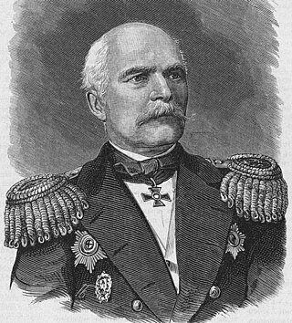
<span class="mw-page-title-main">Island of Montreal</span> Island in Quebec, Canada

The Island of Montreal is a large island in southwestern Quebec, Canada, that is the site of a number of municipalities, including most of the city of Montreal, and is the most populous island in Canada. It is the main island of the Hochelaga Archipelago at the confluence of the Saint Lawrence and Ottawa rivers.

<span class="mw-page-title-main">Rodrigues</span> Autonomous outer island in Mauritius

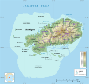
Rodrigues is a 108 km2 (42 sq mi) autonomous outer island of the Republic of Mauritius in the Indian Ocean, about 560 km (350 mi) east of Mauritius. It is part of the Mascarene Islands, which include Mauritius and Réunion. Like Agaléga, Rodrigues is a constituent island of the Republic of Mauritius, under the Constitution of Mauritius and still remains, as explicitly defined by the same Constitution, part of the Sovereignty of Mauritius, together with the following islands: "Agalega, Tromelin, Cargados Carajos, Chagos Archipelago ... Diego Garcia and other islands included in the State of Mauritius".

<span class="mw-page-title-main">Pointe-Claire</span> Suburban municipality of Montreal, Canada

Pointe-Claire is a Quebec local municipality within the Urban agglomeration of Montreal on the Island of Montreal in Canada. It is entirely developed, and land use includes residential, light manufacturing, and retail. As of the 2021 census the population was 33,488.

<span class="mw-page-title-main">Isle de France (Mauritius)</span> 1715–1810 French colony in the Indian Ocean

Isle de France was a French colony in the Indian Ocean from 1715 to 1810, comprising the island now known as Mauritius and its dependent territories. It was governed by the French East India Company and formed part of the French colonial empire. Under the French, the island witnessed major changes. The increasing importance of agriculture led to the importation of slaves and the undertaking of vast infrastructural works that transformed the capital Port Louis into a major port, warehousing, and commercial centre.

<span class="mw-page-title-main">Triolet, Mauritius</span>

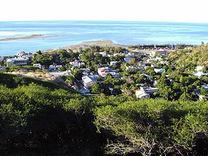
Triolet is a medium-sized town in the north of the Mauritius district of Pamplemousses. It lies exactly 11 kilometres from Port Louis, the capital of the island. The town is nestled amidst green sugarcane fields, near the north-western coast of the island. As per the 2016 population census, Triolet had 24 073 inhabitants and a population density of 2764 inhabitants per km2, over an area of 8.71 m2. The population density is higher than that of the township of Vacoas-Phoenix which is at 1948 inhabitants per km2.

<span class="mw-page-title-main">Trou-aux-Biches</span>

Trou-aux-Biches is a small town with a public beach on the northern coast of Mauritius, in the district of Pamplemousses. According to the World Travel group, the beach is one of the most beautiful on the island. They awarded it the World's Leading Beach Destination at the World Travel Award for 2011. Many tourist resorts and boutique hotels are situated near the beach, such as the Trou aux Biches Resort & Spa. From Port Louis, the M2 highway heads towards it, with Trou-aux-Biches about a mile west from the end of M2. The airport and the town are connected by a public bus.

Articles related to Seychelles include:

<span class="mw-page-title-main">Mauritius campaign of 1809–1811</span> Amphibious and naval operations by the British during the Napoleonic Wars

The Mauritius campaign of 1809–1811 was a series of amphibious operations and naval actions fought to determine possession of the French Indian Ocean territories of Isle de France and Île Bonaparte during the Napoleonic Wars. The campaign lasted from the spring of 1809 until the spring of 1811, and saw both the Royal Navy and the French Navy deploy substantial frigate squadrons with the intention of disrupting or protecting trade from British India. In a war in which the Royal Navy was almost universally dominant at sea, the campaign is especially notable for the local superiority enjoyed by the French Navy in the autumn of 1810 following the British disaster at the Battle of Grand Port, the most significant defeat for the Royal Navy in the entire conflict. After their victory, the British used the original Dutch name of Mauritius for Isle de France. In 1814, Île Bonaparte was returned to France, who eventually renamed it La Réunion.

<span class="mw-page-title-main">Invasion of Isle de France</span> 1810 British invasion of Mauritius during the Napoleonic Wars

The Invasion of Isle de France was a complicated but successful British amphibious operation in the Indian Ocean, launched in November 1810 during the Napoleonic Wars. During the operation, a substantial military force was landed by the Royal Navy at Grand Baie, on the French colony of Isle de France. Marching inland against weak French opposition, the British force was able to overwhelm the defenders in a series of minor engagements, culminating in the capture of the island's capital Port Napoleon and the surrender of Charles Decaen, the French governor. The surrender eliminated the last French territory in the Indian Ocean and among the military equipment captured were five French Navy frigates and 209 heavy cannon. Isle de France was retained by Britain at the end of the war under the name of Mauritius and remained part of the British Empire until 1968.

<span class="mw-page-title-main">Constituencies of Mauritius</span>

Constituencies of Mauritius are the electoral boundaries within the Republic of Mauritius. They are also commonly referred to as Circonscriptions amongst the locals. The country follows the Westminster system and elects 60 members of parliament for a term of 5 years. There are in all 21 Constituencies in the republic, each of them returning 3 members with the exception of Constituency No 21, which returns only 2 members. The Constitution stipulates that there shall be 20 constituencies and one created specially for the Rodrigues island.

<span class="mw-page-title-main">Rivière-Mouchalagane, Quebec</span> Unorganized territory in Quebec, Canada

Rivière-Mouchalagane is an unorganized territory in the Côte-Nord region of Quebec, Canada, part of Caniapiscau Regional County Municipality.

The following is an index of Mauritius-related topics by alphabetical order. For a list by topic, see list of Mauritius-related topics

Joseph Tsang Mang Kin, born 12 March 1938, is a Mauritian poet, political scientist, philosopher and biographer. A former diplomat and ex-politician; Secretary General of the Mauritius Labor Party, Member of the Parliament and Minister of Arts and Culture, he currently operates as a panel member of the African Peer Review Mechanism, African Union.

<span class="mw-page-title-main">Cyclone Amara</span> South-West Indian tropical cyclone in 2013

Intense Tropical Cyclone Amara was a tropical cyclone that brought stormy conditions to Rodrigues in December 2013. Amara was the first named storm in the southwest Indian Ocean during the later half of 2013, and developed from a disturbance within the monsoon trough on December 15. The following day, the system attained tropical depression status. Despite its ill-defined organization, the depression was able to continue strengthening, reaching moderate tropical storm status on December 16 as it tracked southwest. Situated in a favorable atmospheric environment, a period of rapid intensification ensued after Amara reached tropical cyclone status on December 18. After fluctuating in strength, the cyclone peaked with maximum sustained winds of 205 km/h (125 mph) and a minimum barometric pressure of 935 mbar on December 21, making it an intense tropical cyclone based on the intensity scale utilized by Météo-France. Shortly after, wind shear increased as Amara tracked southeast, resulting in a weakening phase. The shearing effects caused the cyclone to rapidly decay, and by December 23, Amara degenerated into a remnant low.

<span class="mw-page-title-main">Marie, Queen of Rodrigues</span>

Marie, Queen of Rodrigues is a six-foot tall statue of the Virgin Mary erected on the heights of Pointe Canon, Rodrigues. The statue is a noted landmark of Port Mathurin and is a gathering place for Catholics on the island as well as a tourist and historical site. The cement statue was inaugurated on May 1, 1954.

<span class="mw-page-title-main">Seychelles Postal Service</span>

The Seychelles Postal Service, is the public operator responsible for postal service in Seychelles.

References

  1. "Island of Rodrigues". Archived from the original on 2010-03-10. Retrieved 2009-06-15.
  2. Yana, Zenovatha. "Admiral Nevelskoi Yacht". shipspotting. shipspotting. Retrieved 1 June 2021.
  3. hksbs.ru, hksbs.ru. "The feat of the explorer of the Far East: to the 205th anniversary of the birth of G. I. Nevelsky: information conversation". hksbs/. The Khabarovsk Regional Specialized Library for the Blind.
  4. Alekseev. "History as an engine of culture". scff. Retrieved 9 June 2021.
  5. "World Meteorological Organization Climate Normals for 1991-2020 — Port Mathurin". National Oceanic and Atmospheric Administration. Retrieved January 4, 2024.