
A barge a typically flat-bottomed vessel which does not have its own means of mechanical propulsion. Original use was on inland waterways, while modern use is on both inland and marine water environments. The first modern barges were pulled by tugs, but on inland waterways, most are pushed by pusher boats, or other vessels. The term barge has a rich history, and therefore there are many types of barges.
Muskogee County is a county located in the U.S. state of Oklahoma. As of the 2020 census, the population was 66,339. The county seat is Muskogee. The county and city were named for the Muscogee (Creek) Nation. The official spelling of the name was changed to Muskogee by the post office in 1900. Muskogee County is part of the Muskogee, OK micropolitan statistical area, which is included in the Tulsa-Muskogee-Bartlesville combined statistical area.

Muskogee is the 13th-largest city in Oklahoma and is the county seat of Muskogee County. Home to Bacone College, it lies approximately 48 miles (77 km) southeast of Tulsa. The population of the city was 36,878 as of the 2020 census, a 6.0% decrease from 39,223 in 2010.

Webbers Falls is a town in southeastern Muskogee County, Oklahoma, United States. The population was 616 at the 2010 census, a decline of 14.9 percent from the figure of 724 recorded in 2000.

Catoosa is a city in Rogers and Wagoner counties in the U.S. state of Oklahoma. The population was 7,440 at the 2020 census compared to 7,159 at the 2010 census.

The Arkansas River is a major tributary of the Mississippi River. It generally flows to the east and southeast as it traverses the U.S. states of Colorado, Kansas, Oklahoma, and Arkansas. The river's source basin lies in Colorado, specifically the Arkansas River Valley. The headwaters derive from the snowpack in the Sawatch and Mosquito mountain ranges. It flows east into Kansas and finally through Oklahoma and Arkansas, where it meets the Mississippi River.

The Indiana Harbor and Ship Canal is an artificial waterway on the southwest shore of Lake Michigan, in East Chicago, Indiana, which connects the Grand Calumet River to Lake Michigan. It consists of two branch canals, the 1.25 miles (2.01 km) Lake George Branch and the 2 miles (3.2 km) long Grand Calumet River Branch which join to form the main Indiana Harbor Canal.

The Verdigris River is a tributary of the Arkansas River in southeastern Kansas and northeastern Oklahoma in the United States. It is about 310 miles (500 km) long. Via the Arkansas, it is part of the Mississippi River watershed.
The Midland Valley Railroad (MV) was a railroad company incorporated on June 4, 1903 for the purpose of building a line from Hope, Arkansas, through Muskogee and Tulsa, Oklahoma to Wichita, Kansas. It was backed by C. Jared Ingersoll, a Philadelphia industrialist who owned coal mining properties in Indian Territory. The railroad took its name from Midland, Arkansas, a coal mining town in western Arkansas, which was served by the railroad. The Midland Valley gained access to Fort Smith, Arkansas via trackage rights over the Frisco from Rock Island, Oklahoma.

Tulsa Ports consists of the ports of Catoosa and Inola near Tulsa, Oklahoma, United States, on the Verdigris River, a tributary of the Arkansas River and the Mississippi River.
Tulsa is the second-largest city in the state of Oklahoma and 45th-most populous city in the United States.

The Port of Beaumont is a deep-water port located in Beaumont, Texas near the mouth of the Neches River.

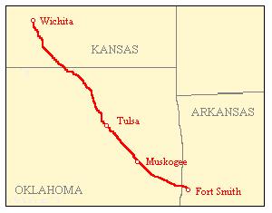
The McClellan–Kerr Arkansas River Navigation System (MKARNS) is part of the United States inland waterway system originating at the Tulsa Port of Catoosa and running southeast through Oklahoma and Arkansas to the Mississippi River. The total length of the system is 445 miles (716 km). It was named for two senators, Robert S. Kerr (D-OK) and John L. McClellan (D-AR), who pushed its authorizing legislation through Congress. The system officially opened on June 5, 1971. President Richard M. Nixon attended the opening ceremony. It is operated by the Army Corps of Engineers (USACE).

Robert S. Kerr Reservoir is located within the Cookson Hills, on the Arkansas River in Sequoyah, Le Flore, Haskell, and Muskogee counties in eastern Oklahoma, US. It is about eight miles south of the nearest major town, Sallisaw, Oklahoma. The reservoir is impounded by Robert S. Kerr Lock and Dam at river mile 336.2 on the Arkansas River, just a few miles below its confluence with the Canadian River. The lock and dam are part of the McClellan-Kerr Arkansas River Navigation System, which provides for barge navigation on the Arkansas River and some of its tributaries. The U.S. Army Corps of Engineers maintains the locks and navigation system.

The Tulsa metropolitan area, officially defined as the Tulsa metropolitan statistical area is a metropolis in northeastern Oklahoma centered around the city of Tulsa and encompassing Tulsa, Rogers, Wagoner, Osage, Creek, Okmulgee and Pawnee counties. It had a population of 1,044,757 according to the 2023 U.S. census estimates.
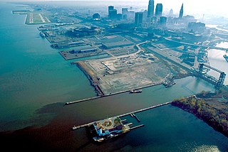
The Port of Cleveland is a bulk freight and container shipping port at the mouth of the Cuyahoga River on Lake Erie in Cleveland, Ohio, United States. It is the third-largest port in the Great Lakes and the fourth-largest Great Lakes port by annual tonnage. Over 20,000 jobs and $3.5 billion in annual economic activity are tied to the roughly 13 million tons of cargo that move through Cleveland Harbor each year.

The Port of Pittsburgh is a vast river traffic region in southwestern Pennsylvania. It spans a thirteen-county area including Allegheny, Armstrong, Beaver, Blair, Butler, Cambria, Clarion, Fayette, Greene, Indiana, Lawrence, Washington, and Westmoreland Counties.

Webbers Falls Lake, also known as Webbers Falls Reservoir, is a reservoir created by a lock and dam on the Arkansas River in Muskogee County, Oklahoma. The normal elevation is 490 feet (150 m). It has 157 miles (253 km) of shoreline and a surface area of 11,600 acres (47,000,000 m2). The drainage area of the lake is 97,033 square miles (251,310 km2). It is an integral part of the McClellan-Kerr Arkansas River Navigation System, which was completed in 1971.
The combination of topographic and climatic factors in the Tulsa, Oklahoma area have frequently caused major flash flooding, especially near streams that normally drain the area. The city was founded atop a bluff on the Arkansas River. Thus, elevation protected most of the inhabitants and their possessions from damage when the river flooded. However, by the turn of the 20th century the population growth had moved closer to the river, and the flatlands west of the Arkansas had begun to develop as well. The floods typically caused widespread property damage and sometimes death. By the 1920s, seasonal floods of the Arkansas began to cause serious damage and loss of life. Since its founding, city leaders had responded to such events by simply rebuilding and replacing the property that had been destroyed in situ. Not until 1970 did the city government begin developing strategies to mitigate floods or at least minimize property damage and prevent loss of life. This article describes some of the more notable floods in Tulsa, then the mitigation and control strategies that evolved from them.
The Ozark and Cherokee Central Railway (O&CC) was formed under the name of the North Arkansas & Western Railway in 1899. At its maximum, it owned a standard gauge, single track line running between Fayetteville, Arkansas and Okmulgee, Oklahoma. Its assets were merged into the St. Louis and San Francisco Railway (Frisco) in 1907.
