Portuguese Cove is a rural community in the Halifax Regional Municipality, Nova Scotia on Route 349 on the Chebucto Peninsula .
Contents

Portuguese Cove in Nova Scotia
Portuguese Cove is a rural community in the Halifax Regional Municipality, Nova Scotia on Route 349 on the Chebucto Peninsula .
The name comes from the Portuguese fishermen who for many years sailed in the summer months fishing in the 18th century. During the War of 1812, the community received the 133 passengers from the wreck of HMS Atalante. [1] A local fishing vessel discovered the passengers in three small vessels stranded in the fog and guided them to safety at Portuguese Cove. Captain Hickey reported, the "inhabitants of Portuguese cove behaved towards us all with every possible mark of hospitality, kindness, and attention, that humanity could dictate." [2]

Peggy's Cove is a small rural community located on the eastern shore of St. Margarets Bay in the Halifax Regional Municipality, which is the site of Peggys Cove Lighthouse.

SS Atlantic was a transatlantic ocean liner of the White Star Line that operated between Liverpool, United Kingdom, and New York City, United States. During the ship's 19th voyage, on 1 April 1873, she struck rocks and sank off the coast of Nova Scotia, Canada, killing at least 535 people. It remained the deadliest civilian maritime disaster in the North Atlantic Ocean until the sinking of SS La Bourgogne on 2 July 1898 and the greatest disaster for the White Star Line prior to the loss of Titanic in April 1912.

Eastern Passage is an unincorporated suburban community in Halifax Regional Municipality Nova Scotia, Canada.
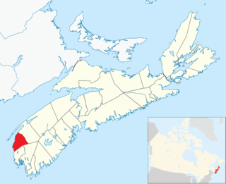
Clare, officially named the Municipality of the District of Clare, is a district municipality in western Nova Scotia, Canada. Statistics Canada classifies the district municipality as a municipal district.
The Aspotogan Peninsula is a peninsula in the eastern part of Lunenburg County, Nova Scotia, separating St. Margarets Bay in the east from Mahone Bay in the west. The peninsula was originally settled by second generation French immigrants on the east side and by second generation German immigrants on the west side. Traditionally fishing was a major industry for communities throughout the peninsula, however other primary industries such as farming and forestry were historically important as well. Shipping and shipbuilding were secondary and tertiary industries that also came into prominence during the 19th and early 20th centuries.
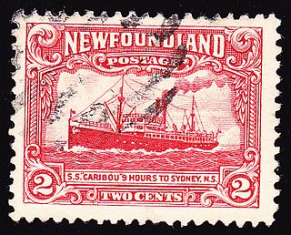
SS Caribou was a Newfoundland Railway passenger ferry that ran between Port aux Basques, in the Dominion of Newfoundland, and North Sydney, Nova Scotia between 1928 and 1942. During the Battle of the St. Lawrence the ferry participated in thrice-weekly convoys between Nova Scotia and Newfoundland. A German submarine attacked the convoy on 14 October 1942 and Caribou was sunk. She had women and children on board, and many of them were among the 137 who died. Her sinking, and large death toll, made it clear that the war had really arrived on Canada's and Newfoundland's home front. Her sinking is cited by many historians as the most significant sinking in Canadian-controlled waters during the Second World War.
Meteghan is an Acadian fishing community along the shores of Baie Sainte-Marie in Clare municipality, Digby County, Nova Scotia, Canada. It is 25 miles northeast of Yarmouth.
Duncans Cove is a small rural community on the Chebucto Peninsula in the Halifax Regional Municipality on the shore of the Atlantic Ocean on the Ketch Harbour Road, 19 kilometers from Halifax. The community is located beside Chebucto Head, the prominent coastal headland.
Head of Jeddore is a rural community of the Halifax Regional Municipality on Trunk 7 on the Eastern Shore of Nova Scotia 47.06 kilometers from Downtown Halifax.
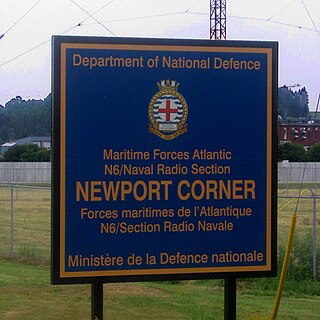
Naval Radio Section Newport Corner is a Canadian Forces naval radio station located in Brooklyn, Nova Scotia. Founded in 1942, it is still in operation today but remotely controlled from CFB Halifax.
Canadian Forces Station Mill Cove is a former Canadian Forces Station and currently a naval radio station located near Hubbards, Nova Scotia. Built in 1967, it is remotely operated by the Canadian Forces from CFB Halifax.
Chebucto Head is a Canadian headland on Nova Scotia's Chebucto Peninsula located within the community of Duncan's Cove.

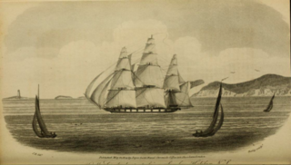
HMS Tribune was a Royal Navy 36-gun fifth rate. This frigate was originally the French Galathée-class frigateCharente Inférieure, which was launched in 1793 during the French Revolutionary Wars and renamed Tribune the next year. The British captured her and took her into service with the Royal Navy. She only served for a year before being wrecked off of Herring Cove, Nova Scotia on 16 or 23 November 1797. Of the 240 men on board, all but 12 of her crew were lost.
East Jeddore is a small rural fishing community of the Halifax Regional Municipality in the Canadian province of Nova Scotia. It is 45 minutes East of Dartmouth along Highway 7. East Jeddore Road is approximately 11 kilometers long and generally follows Jeddore Harbour from its basin in Oyster Ponds to the mouth.

Indian Harbour is a small fishing community of the Halifax Regional Municipality in the Canadian province of Nova Scotia on the Chebucto Peninsula. It is located between the communities of Peggy's Cove and Hackett's Cove.
Noel is a community in the Canadian province of Nova Scotia, located in the Municipal District of East Hants, which is in Hants County, Nova Scotia. The community is most well known for being named after its most prominent resident Noël Doiron and for ship building in the nineteenth century. Noel Doiron is the namesake of the village as well as the surrounding communities of Noel Shore, Nova Scotia, East Noel, Noel Road, Nova Scotia, North Noel Road, Nova Scotia. The earliest recorded reference to the community of "Noel" was by surveyor Charles Morris in 1752. Prior to that date, the area is referred to as "Trejeptick", which first appears in the Colonial Office minutes of Annapolis Royal in 1734. Noel was also the home of the Osmond O'Brien Shipyard.
Petit-de-Grat is a small Acadian community in the Canadian province of Nova Scotia, located in Richmond County on Petit-de-Grat Island. Its name comes from the Basque word "dégrat" which means "fishing station" or "whaling station".

The Battle of Winnepang occurred during Dummer's War when New England forces attacked Mi'kmaq at present day Jeddore Harbour, Nova Scotia. The naval battle was part of a campaign ordered by Governor Richard Philipps to retrieve over 82 New England prisoners taken by the Mi'kmaq in fishing vessels off the coast of Nova Scotia. The New England force was led by Ensign John Bradstreet and fishing Captain John Elliot.
Herring Cove is a Canadian suburban and former fishing community in Nova Scotia's Halifax Regional Municipality. It is situated on the eastern shore of the Chebucto Peninsula, 15 km (9.3 mi) south of Downtown Halifax. It is near the western approaches to Halifax Harbour, and can be reached both via Purcell's Cove along the coastal road and from inland via the Herring Cove Road through Spryfield. There are two schools in Herring Cove, William King Elementary and Herring Cove Junior High. The community is also home to a small variety of small businesses and programs.
HMS Atalante was an 18-cannon sloop-of-war launched in 1808 in Bermuda. She was wrecked on 10 November 1813 because of fog off Halifax, Nova Scotia.
Coordinates: 44°31′18.8″N63°32′6.9″W / 44.521889°N 63.535250°W
| | This Halifax County, Nova Scotia location article is a stub. You can help Wikipedia by expanding it. |