Post Falls is a city in Kootenai County, Idaho, United States. It is the gateway city to North Idaho on I-90 just west of Coeur d'Alene and east of Spokane, Washington. The population was 38,485 at the time of the 2020 census, up from 27,574 in the 2010 census, making it Idaho's eleventh-largest city and the second largest city in North Idaho behind Coeur d’Alene.

Coeur d'Alene is a city and the county seat of Kootenai County, Idaho, United States. It is the largest city in North Idaho and the principal city of the Coeur d'Alene Metropolitan Statistical Area. At the 2020 census the city's population was 54,628. Coeur d'Alene is a satellite city of Spokane, which is located about thirty miles (50 km) to the west in the state of Washington. The two cities are the key components of the Spokane–Coeur d'Alene Combined Statistical Area, of which Coeur d'Alene is the third-largest city. The city is situated on the north shore of the 25-mile (40 km) long Lake Coeur d'Alene and to the west of the Coeur d'Alene Mountains. Locally, Coeur d'Alene is known as the "Lake City," or simply called by its initials, "CDA."

Spokane is the most populous city in and seat of government of Spokane County Washington, United States. It is in eastern Washington, along the Spokane River, adjacent to the Selkirk Mountains, and west of the Rocky Mountain foothills, 92 miles (148 km) south of the Canadian border, 18 miles (30 km) west of the Washington–Idaho border, and 279 miles (449 km) east of Seattle, along I-90.
The Inland Northwest, historically and alternatively known as the Inland Empire, is a region of the American Northwest centered on the Greater Spokane, Washington Area, encompassing all of Eastern Washington and North Idaho. Under broader definitions, Northeastern Oregon and Western Montana may be included in the Inland Northwest. Alternatively, stricter definitions may exclude Central Washington and Idaho County, Idaho.

The Spokane River is a tributary of the Columbia River, approximately 111 miles (179 km) long, in northern Idaho and eastern Washington in the United States. It drains a low mountainous area east of the Columbia, passing through the Spokane Valley and the city of Spokane, Washington.
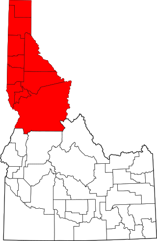
The Idaho Panhandle—locally known as North Idaho—is a salient region of the U.S. state of Idaho encompassing the state's 10 northernmost counties: Benewah, Bonner, Boundary, Clearwater, Idaho, Kootenai, Latah, Lewis, Nez Perce, and Shoshone. The Panhandle is bordered by the state of Washington to the west, Montana to the east, and the Canadian province of British Columbia to the north. The Idaho panhandle, along with Eastern Washington, makes up the region known as the Inland Northwest, headed by its largest city, Spokane, Washington.

Lake Pend Oreille in the northern Idaho Panhandle is the largest lake in the U.S. state of Idaho and the 38th-largest lake by area in the United States, with a surface area of 148 square miles (380 km2). It is 69 kilometres (43 mi) long, and 1,152 feet (351 m) deep in some regions, making it the fifth-deepest in the nation and having a volume of 43,939,940 acre feet = 54 km3. The lake is fed by the Clark Fork River and the Pack River, and drains into the Pend Oreille River, as well as subsurfacely into the Spokane Valley–Rathdrum Prairie Aquifer. It is surrounded by national forests and a few small towns, with the largest population on the lake at Sandpoint. The majority of the shoreline is non-populated and all but the southern tip of the lake is in Bonner County. The southern tip is in Kootenai County and is home to Farragut State Park, formerly the Farragut Naval Training Station during World War II, of which a small part is still active and conducts U.S. Navy acoustic underwater submarine research.

The Spokan or Spokane people are a Native American Plateau tribe who inhabited the eastern portion of present-day Washington state and parts of northern Idaho in the United States of America.

Lake Coeur d'Alene, officially Coeur d'Alene Lake, is a natural dam-controlled lake in North Idaho, located in the Pacific Northwest region of the United States. At its northern end is the city of Coeur d'Alene. It spans 25 miles (40 km) in length and ranges from 1 to 3 miles (5 km) wide with over 109 miles (175 km) of shoreline.

Spokane Falls is the name of a waterfall and dam on the Spokane River, located in the central business district in downtown Spokane, Washington. The city of Spokane was also initially named "Spokane Falls".

Lake Chelan Dam officially known as the Lake Chelan Hydroelectric Project is located approximately 32 miles (51 km) north of the city of Wenatchee in Chelan County. The dam is located at the lower or southeasterly end of 50.4 miles long Lake Chelan, and is within the limits of the city of Chelan. The powerhouse is located near the community of Chelan Falls. The reservoir has 677,400 acre-feet (835,600,000 m3) of usable water storage. The 10-year average generation for the Project is 365,000 megawatt hours.

The Coeur d'Alene Resort is a resort hotel in the northwest United States, located in Coeur d’Alene, Idaho. Seated on the north shore of Lake Coeur d'Alene by Tubbs Hill, the resort features a marina, convention facilities, spa, as well as a notable 18-hole golf course.

Interstate 90 (I-90) is a transcontinental Interstate Highway that runs east–west across the northern United States. Within the state of Idaho, the freeway travels for 74 miles (119 km) from the Washington border near Spokane to Coeur d'Alene and the panhandle region at the north end of the state. After traveling through the Silver Valley along the Coeur d'Alene River in the Bitterroot Range, I-90 crosses into Montana at Lookout Pass.

The history of Spokane, Washington in the northwestern United States developed because Spokane Falls and its surroundings were a gathering place for numerous cultures for thousands of years. The area's indigenous people settled there due to the fertile hunting grounds and abundance of salmon in the Spokane River. The first European to explore the Inland Northwest was Canadian explorer-geographer David Thompson, working as head of the North West Company's Columbia Department. At the nexus of the Little Spokane and the Spokane, Thompson's men built a new fur trading post, which is the first long-term European settlement in Washington state.

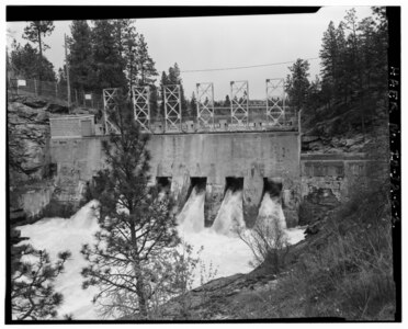
The Saint Joe River is a 140-mile (225 km) long tributary of Coeur d'Alene Lake in northern Idaho. Beginning at an elevation of 6,487 feet (1,977 m) in the Northern Bitterroot Range of eastern Shoshone County, it flows generally west through the Saint Joe River Valley and the communities of Avery and Calder. Past Calder, it flows into Benewah County and through the town of St. Maries, where it receives its largest tributary, the Saint Maries River. It then turns northwest, passing through Heyburn State Park before reaching its mouth just north of the Kootenai County line. Much of the river's route through Heyburn State Park is partially flooded due to raised water levels from the Washington Water Power dam at Post Falls on the Spokane River below Coeur d'Alene Lake. With a mouth elevation of 2,129 feet (649 m), it is claimed to be the highest navigable river in the world. Multiple rivers in Canada are both higher and navigable, including the Babine, and Middle Rivers.
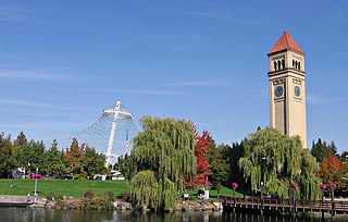
Riverfront Park, branded as Riverfront Spokane, is a public urban park in downtown Spokane, Washington that is owned and operated by the Spokane Parks & Recreation Department. The 100-acre (40 ha) park is situated along the Spokane River and encompasses the Upper Spokane Falls, which is the second largest urban waterfall in the United States.

The economy of the Spokane Metropolitan Area plays a vital role as the hub for the commercial, manufacturing, and transportation center as well as the medical, shopping, and entertainment hub of the 80,000 square miles (210,000 km2) Inland Northwest region. Although the two have opted not to merge into a single Metropolitan Statistical Area (MSA) yet, the Coeur d'Alene MSA has been combined by the Census Bureau into the Spokane–Coeur d'Alene combined statistical area (CSA). The CSA comprises the Spokane metropolitan area and the Coeur d'Alene metropolitan area anchored by Coeur d'Alene, Idaho. According to the U.S. Bureau of Labor Statistics, the Spokane metropolitan area has a workforce of about 287,000 people and an unemployment rate of 5.3 percent as of February 2020; the largest sectors for non–farm employment are education and health services, trade, transportation, and utilities, and government. The Coeur d'Alene metropolitan area has a workforce of 80,000 people and an unemployment rate of 6.8% as of June 2020; the largest sectors for non-farm employment are trade, transportation, and utilities, government, and education and health services as well as leisure and hospitality. In 2017, the Spokane–Spokane Valley metropolitan area had a gross metropolitan product of $25.5 billion while the Coeur d'Alene metropolitan area was $5.93 billion.

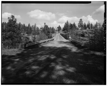
The North Idaho Centennial Trail is a 24 miles (39 km) paved trail in Idaho used for transportation and recreational activities. Extending from Higgens Point on the northeast side of Lake Coeur d'Alene, a popular place for bald eagle watchers in early winter, the trail follows the lake's north shoreline to the Spokane River where it follows it to the Idaho/Washington border. On the other side of the state border, the trail becomes the Spokane River Centennial Trail and extends for another 37 miles (60 km) out to Sontag Park in Nine Mile Falls, Washington. The trail passes through the towns of Post Falls, Idaho and Coeur d'Alene, Idaho.
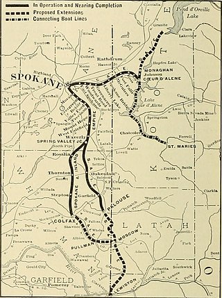
The Spokane and Inland Empire Railroad Company (S.&I.E.R.R.Co.) was an electrified interurban railway operating in Spokane, Washington and vicinity, extending into northern and central Idaho. The system originated in several predecessor roads beginning c. 1890, incorporated in 1904, and ran under its own name to 1929. It merged into the Great Northern Railway and later, the Burlington Northern Railroad, which operated some roads into the 1980s.