
Bad Suderode is a village and a former municipality in the district of Harz, Saxony-Anhalt, Germany. Since 1 January 2014, it has for administrative purposes been included as part of the municipality of Quedlinburg. It is situated in a valley in the northern part of the Harz mountains, on the road from Quedlinburg to Friedrichsbrunn.

Ottersberg is a municipality in the district of Verden, in Lower Saxony, Germany. It is situated approximately 20 km north of Verden, and 28 km east of Bremen.

Großschirma is a town in the district of Mittelsachsen, in the Free State of Saxony, Germany. It is situated 7 km northwest of Freiberg. It was formed from the administrative union of the village of Großschirma and the town of Siebenlehn, including their districts, on 1 September 2003.

Espenau is a municipality in the district of Kassel, in Hesse, Germany, composed of the districts of Espenau-Hohenkirchen and Espenau-Mönchehof. It is situated 9 kilometers north of Kassel. As of December 2019, Espenau has 5,158 inhabitants. It covers a total area of 13.59 km².

Rom is a municipality in the Ludwigslust-Parchim district, in Mecklenburg-Vorpommern, Germany.

The Bavarian Maximilian Order for Science and Art was first established on 28 November 1853 by King Maximilian II von Bayern. It is awarded to acknowledge and reward excellent and outstanding achievements in the field of science and art. From 1933 onwards the order was no longer awarded, until 1980 when it was reinstated by the then Minister-President of the Free State of Bavaria Franz Josef Strauß. Munich jewellers Hemmerle have been responsible for making the medal since 1905.
The Gerichtsbezirk Oberburg was in the Bezirksgericht Oberburg with was under the Gerichtsbezirk of the state of Steiermark. It was composed of part of the Bezirks Cilli (Celje) and was lost to Yugoslavia in 1919.
The Styria municipal structural reform was a local government reform in the Austrian state of Styria, which was made effective January 1, 2015. This reform nearly halved the number of Styrian municipalities as the reduced from 542 to 287. The reform was intended to reduce costs and ease election of new town officials. The terms of the reform is formalized in the Styrian Municipality Structural Reform Act. (StGsrG). The law was adopted on December 17, 2013 by the Landtag of Styria, and promulgated on April 2, 2014.

Raaba-Grambach is a market town in the district Graz-Umgebung in Styria, Austria since 2015. It was created as part of the Steiermärkische Gemeindestrukturreform of Styria at the end of 2014, dissolving the towns Raaba and Grambach. One complaint from both communities against merging was raised at the Constitutional Court but ended unsuccessfully.

Pischelsdorf am Kulm is since 2015 a municipality in Weiz District in Styria, Austria. The area of the town covers 28.14 square kilometres (10.86 sq mi). In the Styria municipal structural reform, the new town was formed by merging Pischelsdorf in der Steiermark with the smaller villages of Reichendorf and Kulm bei Weiz, to reduce costs and ease election of town officials.
Sankt Georgen am Kreischberg is since 2015 a municipality in Murau District in Styria, Austria. It was created as part of the Styria municipal structural reform, out of the former independent towns Sankt Georgen ob Murau and Sankt Ruprecht-Falkendorf. The town church after the changes, which began in November 2013, had continued the name "Sankt Georgen ob Murau", which was corrected through an amendment in April 2014.

Dobl-Zwaring is a market town with 3,445 residents in Styria, Austria. It lies in the southwest part of Graz-Umgebung District.

Gutenberg-Stenzengreith is a municipality since 2015 in the Weiz District of Styria, Austria. It was created as part of the Styria municipal structural reform, at the end of 2014, by merging the former towns of Gutenberg an der Raabklamm and Stenzengreith.
Irdning-Donnersbachtal is a new municipality since January 2015 with 4,137 residents in the Liezen District of Styria, Austria.
Leutschach an der Weinstraße is since January 2015 a new municipality with 3,794 residents in the Leibnitz District of Styria, Austria.
Premstätten is since January 2016 a new market town with 5,784 residents in Graz-Umgebung District of Styria, Austria. However, it was previously founded in January 2015 as the town name "Unterpremstätten-Zettling".
Schwarzautal is a market town since 2015 with 2,299 residents in the Leibnitz District of Styria, Austria.
Seiersberg-Pirka is a municipality with 10,746 residents, and after Gratwein-Straßengel, the 2nd-largest municipality of Graz-Umgebung District in Styria, Austria.
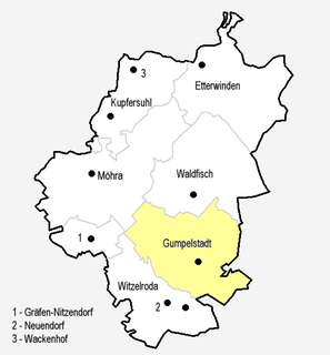
Gumpelstadt is a village of the Moorgrund municipality in the Wartburgkreis district in Thuringia, Germany.

Bassen is a district and a village in the municipality Oyten in Lower Saxony. The place is about 20 km east of the city center of Bremen and about 100 km southwest of Hamburg. In the northern area the Wümme flows through Bassen. It has 3,318 inhabitants (2016).


