
Albota is a commune in Argeș County, in southern central Romania. It is composed of five villages: Albota, Cerbu, Frătești, Gura Văii and Mareș.
Rutki-Bronisze is a village in the administrative district of Gmina Ciechanów, within Ciechanów County, Masovian Voivodeship, in east-central Poland.
Wólka Rydzewska is a village in the administrative district of Gmina Ciechanów, within Ciechanów County, Masovian Voivodeship, in east-central Poland.
Rumunki is a village in the administrative district of Gmina Gostynin, within Gostynin County, Masovian Voivodeship, in east-central Poland.

Budy Sułkowskie is a village in the administrative district of Gmina Strzegowo, within Mława County, Masovian Voivodeship, in east-central Poland. It lies approximately 11 kilometres (7 mi) north-east of Strzegowo, 17 km (11 mi) south of Mława, and 93 km (58 mi) north-west of Warsaw.
Budy Wolińskie is a village in the administrative district of Gmina Strzegowo, within Mława County, Masovian Voivodeship, in east-central Poland. It lies approximately 9 kilometres (6 mi) south-east of Strzegowo, 28 km (17 mi) south of Mława, and 83 km (52 mi) north-west of Warsaw.
Czarnocinek is a village in the administrative district of Gmina Strzegowo, within Mława County, Masovian Voivodeship, in east-central Poland. It lies approximately 25 kilometres (16 mi) south of Mława and 87 km (54 mi) north-west of Warsaw.
Aleksandrowo is a village in the administrative district of Gmina Nasielsk, within Nowy Dwór Mazowiecki County, Masovian Voivodeship, in east-central Poland. It lies approximately 8 kilometres (5 mi) south of Nasielsk, 14 km (9 mi) north-east of Nowy Dwór Mazowiecki, and 38 km (24 mi) north of Warsaw.
Chechnówka is a village in the administrative district of Gmina Nasielsk, within Nowy Dwór Mazowiecki County, Masovian Voivodeship, in east-central Poland. It lies approximately 8 kilometres (5 mi) south-east of Nasielsk, 18 km (11 mi) north-east of Nowy Dwór Mazowiecki, and 39 km (24 mi) north of Warsaw.
Dąbrowa is a village in the administrative district of Gmina Nasielsk, within Nowy Dwór Mazowiecki County, Masovian Voivodeship, in east-central Poland.
Mokrzyce Włościańskie is a village in the administrative district of Gmina Nasielsk, within Nowy Dwór Mazowiecki County, Masovian Voivodeship, in east-central Poland.
Toruń Dworski is a village in the administrative district of Gmina Nasielsk, within Nowy Dwór Mazowiecki County, Masovian Voivodeship, in east-central Poland. It lies approximately 11 kilometres (7 mi) south-west of Nasielsk, 10 km (6 mi) north of Nowy Dwór Mazowiecki, and 39 km (24 mi) north-west of Warsaw.
Toruń Włościański is a village in the administrative district of Gmina Nasielsk, within Nowy Dwór Mazowiecki County, Masovian Voivodeship, in east-central Poland. It lies approximately 11 kilometres (7 mi) south-west of Nasielsk, 10 km (6 mi) north of Nowy Dwór Mazowiecki, and 39 km (24 mi) north-west of Warsaw.
Żabiczyn is a village in the administrative district of Gmina Nasielsk, within Nowy Dwór Mazowiecki County, Masovian Voivodeship, in east-central Poland. It lies approximately 7 kilometres (4 mi) south-east of Nasielsk, 18 km (11 mi) north-east of Nowy Dwór Mazowiecki, and 39 km (24 mi) north of Warsaw.
Pilitowo is a village in the administrative district of Gmina Płońsk, within Płońsk County, Masovian Voivodeship, in east-central Poland.
Bogucin is a village in the administrative district of Gmina Raciąż, within Płońsk County, Masovian Voivodeship, in east-central Poland. It lies approximately 5 kilometres (3 mi) south-west of Raciąż, 24 km (15 mi) north-west of Płońsk, and 86 km (53 mi) north-west of Warsaw.
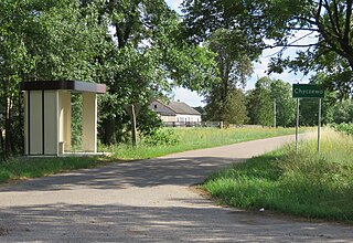
Chyczewo is a village in the administrative district of Gmina Raciąż, within Płońsk County, Masovian Voivodeship, in east-central Poland. It lies approximately 6 kilometres (4 mi) south-west of Raciąż, 24 km (15 mi) north-west of Płońsk, and 85 km (53 mi) north-west of Warsaw.
Bogdaniec is a village in the administrative district of Gmina Sochaczew, within Sochaczew County, Masovian Voivodeship, in east-central Poland. It lies approximately 8 kilometres (5 mi) east of Sochaczew and 45 km (28 mi) west of Warsaw.
Pniowe is a village in the administrative district of Gmina Puszcza Mariańska, within Żyrardów County, Masovian Voivodeship, in east-central Poland.
Łubno is a village in the administrative district of Gmina Wiskitki, within Żyrardów County, Masovian Voivodeship, in east-central Poland.


