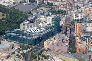
Potsdamer Platz is a public square and traffic intersection in the center of Berlin, Germany, lying about 1 km (1,100 yd) south of the Brandenburg Gate and the Reichstag, and close to the southeast corner of the Tiergarten park. It is named after the city of Potsdam, some 25 km (16 mi) to the south west, and marks the point where the old road from Potsdam passed through the city wall of Berlin at the Potsdam Gate. After developing within the space of little over a century from an intersection of rural thoroughfares into the most bustling traffic intersection in Europe, it was totally destroyed during World War II and then left desolate during the Cold War era when the Berlin Wall bisected its former location. Since German reunification, Potsdamer Platz has been the site of major redevelopment projects.

Hallesches Tor is a Berlin U-Bahn station in the central Kreuzberg quarter, served by lines U1, U3, and U6. It is named after the historic Hallsches Tor of the Berlin Customs Wall, erected in the 18th century.
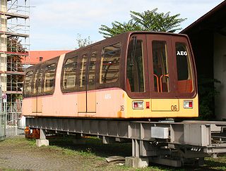
The M-Bahn or Magnetbahn was an elevated Maglev train line operating in Berlin, Germany, experimentally from 1984 and in passenger operation from 1989 to 1991. The line was 1.6 kilometres (1 mi) in length, and featured three stations, two of which were newly constructed. Presumed to be the future of rail transit in Berlin, the line was built to fill a gap in the West Berlin public transport network created by the construction of the Berlin Wall. It was rendered redundant by the reunification of Berlin and was closed to enable reconstruction of the U2 line.

The Oberbaum Bridge is a double-deck bridge crossing Berlin's River Spree, considered one of the city's landmarks. It links Friedrichshain and Kreuzberg, former boroughs that were divided by the Berlin Wall, and has become an important symbol of Berlin's unity.

The Potsdamer Bahnhof is a former railway terminus in Berlin, Germany. It was the first railway station in Berlin, opening in 1838. It was located at Potsdamer Platz, about 1 km south of the Brandenburg Gate, and kick-started the transformation of Potsdamer Platz from an area of quiet villas near the south-east corner of the Tiergarten park into the bustling focal point that it eventually became. For more than a century it was the terminus for long-distance and suburban trains. Also located at this spot were underground stations on the Berlin U-Bahn and S-Bahn, and today's new underground Regionalbahnhof, known as Bahnhof Potsdamer Platz, while the short-lived M-Bahn crossed the site of the former terminus.

The Potsdam City Palace is a building in Potsdam, Germany, located on the Old Market Square, next to the St. Nicholas' Church (Nikolaikirche). It was the second official residence of the margraves and electors of Brandenburg, later kings in Prussia, kings of Prussia and German emperors.
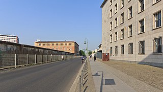
Niederkirchnerstraße is a street in Berlin, Germany and was named after Käthe Niederkirchner. The thoroughfare was known as Prinz-Albrecht-Straße until 1951 but the name was changed by the socialist German government. The street was the location of the SS Reich Security Main Office (RSHA), the headquarters of the Sicherheitspolizei, SD, Einsatzgruppen and Gestapo. The site is now marked by the Topography of Terror memorial and a museum, which includes a permanent exhibition showing the crimes of Nazism.

Ebertstraße is a street in Berlin, the capital of Germany. It runs on a roughly north-south line from the Brandenburg Gate to Potsdamer Platz in the centre of the city.

Voßstraße ; German pronunciation: [ˈfɔsˌʃtʁaːsə] is a street in central Berlin, the capital of Germany. It runs east–west from Ebertstraße to Wilhelmstraße in the borough of Mitte, one street north of Leipziger Straße and very close to Potsdamer Platz. It is best known for being the location of Hitler's new Reich Chancellery complex, and the bunker where he spent his last days.

Leipziger Straße is a major thoroughfare in the central Mitte district of Berlin, capital of Germany. It runs from Leipziger Platz, an octagonal square adjacent to Potsdamer Platz in the west, to Spittelmarkt in the east. Part of the Bundesstraße 1 highway, it is today one of the city's main east–west road links.

Tiergartenstraße is a street in the Tiergarten district in central Berlin, the capital of Germany. The street runs east-west along the southern edge of the Großer Tiergarten park from Kemperplatz and Ben-Gurion-Straße near Sony Center and Potsdamer Platz in the east to the intersection of Hofjägerallee and Klingelhöferstraße in the west. On the street’s southern side, the street intersects with, Herbert-von-Karajan-Straße, Stauffenbergstraße, Hildebrandstraße, Hiroshimastraße and Clara-Wieck-Straße.

The Anhalter Bahnhof is a former railway terminus in Berlin, Germany, approximately 600 m (2,000 ft) southeast of Potsdamer Platz. Once one of Berlin's most important railway stations, it was severely damaged in World War II, and finally closed for traffic in 1952, when the GDR-owned Deutsche Reichsbahn rerouted all railway traffic between Berlin and places in the GDR avoiding the West Berlin area. The station's name lives on in the Berlin S-Bahn station of the same name, opened in October 1939 as part of the North-South S-Bahn link.

Schwartzkopffstraße is a Berlin U-Bahn station located on the line.

Berlin Yorckstraße is an S-Bahn and U-Bahn station located in the Schöneberg locality of central Berlin, Germany.
Leipziger Platz is an octagonal square in the center of Berlin. It is located along Leipziger Straße just east of and adjacent to the Potsdamer Platz.

The North–South S-Bahn Tunnel is the central section of the North–South transversal Berlin S-Bahn connection crossing the city centre. It is not to be confused with the Tunnel Nord–Süd Fernbahn, the central tunnel part of the North–South main line used by intercity and regional trains. The S-Bahn North–South line encompasses the route from Bornholmer Straße and Gesundbrunnen via Friedrichstraße and Anhalter Bahnhof to Papestraße and Schöneberg.

The Berlin Customs Wall was a ring wall around the historic city of Berlin, between 1737 and 1860; the wall itself had no defence function but was used to facilitate the levying of taxes on the import and export of goods (tariffs) which was the primary income of many cities at the time.

The Museum of Film and Television Berlin is one of seven film museums in Germany, and is located at Potsdamer Straße 2 in Berlin. It opened in 2000 as part of the Deutsche Kinemathek, the German Film Archive and Museum for Film and Television.
The Hallesches Tor was located in today's Berlin district Kreuzberg south of Mehringplatz. Today, as a historic monument listed underground station on the site of the former gate bears the name Hallesches Tor. It is a major transfer point for the underground lines / and as well as the bus lines 248 and M41. The station is connected by the Hallesche-Tor-Brücke with the Blücherplatz to the south. The Amerika-Gedenkbibliothek and the nearby Jewish Museum contribute to the heavy visitor traffic in the area around the Hallesches Tor.

Rosenthaler Platz in Berlin's Mitte district, district Mitte, forms a crossroads where Rosenthaler Strasse, Brunnenstrasse and Weinbergsweg meet Torstrasse, and is therefore not a square in the true sense of the word. It is located on the site of the former Rosenthaler Tor of the Berlin customs wall, from which a road led to the village of Rosenthal. This gate was one of the few through which Jews were allowed to enter Berlin until the 19th century. Those who were not allowed to enter could stay overnight in a special Jewish hostel.
