Related Research Articles
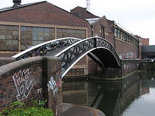
Bordesley is an area of Birmingham, England, 1.2 miles (2 km) south east of the city centre straddling the Watery Lane Middleway ring road. It should not be confused with nearby Bordesley Green. Commercial premises dominate to the west of the ring road, but much of this area is to be redeveloped. Blocks of residential apartments are planned and set for completion from the mid-2020s onwards. The largely residential area east of the ring road was renamed Bordesley Village following large scale clearance of back-to-back houses and redevelopment in the 1980s and 90s. Bordesley is the real life setting of the BBC series Peaky Blinders, and home to Birmingham City Football Club's ground, St Andrew's.

Known as the Hagley Road in Birmingham, the A456 is a main road in England running between Central Birmingham and Woofferton, Shropshire, south of Ludlow. Some sections of the route, for example Edgbaston near Bearwood, are also the route of the Elan Aqueduct which carries Birmingham's water supply from the Elan Valley.
Walsgrave on Sowe, or simply Walsgrave, is a suburban district situated approximately 3.5 miles (5.6 km) north-east of central Coventry, West Midlands, central England. Although it now experiences very little flooding, it was built on marshlands. However, due to urban growth, it is now an outer suburb of Coventry, south-west of the villages of Ansty and Shilton. Walsgrave on Sowe neighbours the Potters Green, Clifford Park, Woodway Park, Wyken, Henley Green and Mount Pleasant areas of Coventry, and is in the Henley ward of the city, although Walsgrave-on-Sowe was formerly in the Wyken Ward prior to ward changes made in 2003 by the Local Government Boundary Commission for England (LGBCE).

Ball Hill is an area within the Stoke district of Coventry, West Midlands, England. It is to the east of Coventry city centre.
Keresley is a suburban village and civil parish in the City of Coventry, West Midlands, England, about 4.5 miles (7 km) north of Coventry city centre and 3.5 miles (6 km) southwest of Bedworth. According to the 2001 census, the parish had a population of 791 falling to 713 at the 2011 Census, although the 2018 population was estimated at 783. Keresley and Keresley End are two separate areas; Keresley is in Coventry, while the slightly more rural Keresley End, also known as Keresley village or Keresley Newlands, is in Warwickshire, with the exception of Thompsons Road in the village, which lies within the Coventry boundary. The village features two grocers shops, two bus stops, a beauty salon, primary school, doctors surgery, a fish and chip shop, a small church, a post office, library, park, garden centre and community centre.

The A105 road is an A road in London, England. It runs from Canonbury, in between Highbury and Dalston, to Enfield Town. The road is 8 miles (13 km) long. Part of the road forms Green Lanes, one of the longest streets in London, while the A105 also serves as the primary access route to the Shopping City shopping centre in Wood Green.
Eastern Green is a mainly residential suburb in the far west of Coventry, England, and was formerly a village in Warwickshire. Its most western area is Upper Eastern Green and the eastern area is Lower Eastern Green, though residents generally do not distinguish between the two.

Glen Shee is a glen in eastern Perthshire, Scotland. Shee Water flows through the glen. The head of the glen, where Gleann Taitneach and Glen Lochsie meet, is approximately 2 km north-west of the Spittal of Glenshee; it then runs south-east to Bridge of Cally where it merges with Strathardle to form Glen Ericht. Once known as the glen of the fairies it takes its name from the Gaelic "sith" meaning fairy and the old meeting place at the standing stone behind the present day church is called Dun Shith or Hill of the Fairies.

Elmdon is a suburban village within the Metropolitan Borough of Solihull in the county of West Midlands, England. The population of this Solihull Ward at the 2011 census was 12,067.

Foleshill is a suburb in the north of Coventry in the West Midlands of England. Longford, Courthouse Green and Rowley Green are to its north and Keresley is to its west. The population of the Ward at the 2011 census was 19,943.

The A444 is a primary road running between Coventry and Burton upon Trent in England, usually referred to as the "A treble four" or "A triple four".

Tile Hill is a suburb in the west of Coventry, West Midlands, England. It is mostly residential and partly industrial, with some common land and wooded areas. Tile Hill railway station is located on the West Coast Main Line which links Coventry with London and Birmingham, and is situated at the southwestern border with the city's Canley district and the Metropolitan Borough of Solihull.
Woodway Park School and Community College was a comprehensive school in Coventry, England. It had an expanding sixth form.

Coundon is a predominantly residential suburb in north-west Coventry, West Midlands, England.
Stoke Heath is a residential area of Coventry, West Midlands, England. It is situated approximately 1 mile (1.6 km) to the north east of the city centre. It borders Courthouse Green to the north, Wyken to the east and Stoke to the south with its western edge demarcated by the A444.

Courthouse Green is a suburb in the north of Coventry. It is bordered by Bell Green in the northwest, by Stoke Heath in the south, and by Foleshill in the southeast.
Keresley End is a village in the Nuneaton & Bedworth District of Warwickshire, England, also known as Keresley Village or Keresley Newlands. Population details can be found under Exhall. It is situated approximately 1.5 km north of Keresley, a suburb of Coventry, and, being close to the former Keresley colliery, it was where many coal miners lived.
Henley Green is a former council estate in Coventry at grid reference SP366815 adjacent to Wood End, bordered by Deedmore Road, and about a mile from the area of Bell Green. Henley Green now consists of a mixture of private and social housing. The neighbourhood is part of the Henley ward.
Little Heath is an area of Coventry, in the county of West Midlands, in England. Most of the Little Heath area is in the Longford ward of the city.
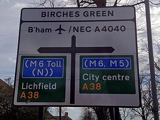
Birches Green is a small area of Tyburn in Birmingham, England, within the parliamentary constitiuency of Erdington. It is located between Gravelly Hill, Erdington and the M6 motorway.
References
- ↑ "Potter's Green". GetOutside. Ordnance Survey. Retrieved 12 February 2023.
- ↑ AA Street by Street. Coventry Rugby (2nd ed.). AA Publishing. May 2003. pp. 24–5. ISBN 0-7495-3973-9.
Coordinates: 52°25′59″N1°27′25″W / 52.433°N 1.457°W
| | This West Midlands location article is a stub. You can help Wikipedia by expanding it. |