Powers Bluff

Last updated

Powers Bluff
Indian Bill Cemetery.jpg
Location Arpin, Wisconsin
NRHP reference No. 02000732
Added to NRHPJuly 5, 2002 [1]

Powers Bluff is a wooded hill in central Wisconsin near Arpin. American Indians lived there until the 1930s, calling it Tah-qua-kik, or Skunk Hill. Because of their religious and ceremonial activities, Tah-qua-kik is listed on the National Register of Historic Places. [1]

Contents

Today part of the hill is occupied by Powers Bluff County Park, locally known for its inner-tube hill on winter weekends. At 1472 feet above sea level, it is the highest point in Wood County. [2]

Natural history

Quartzite outcrops like this run along the crest of the bluff, generally WNW to ESE. Outcrop on Powers Bluff.jpg
Quartzite outcrops like this run along the crest of the bluff, generally WNW to ESE.

The most striking geological feature at Powers Bluff is the stone outcrops poking out the top of the hill. In some places they rise 25 feet above the forest floor. The bluff is quartzite with a peak of chert. Geologists believe the quartzite to be from the Proterozoic era, [3] 1.6 billion years old, similar in age and composition to Rib Mountain to the northeast and the Baraboo Hills [4] to the south, and much older than the Himalayas. The quartzite is pretty pink, a semi-precious stone, and very hard. The softer materials which once surrounded it have been gradually stripped away by erosion, leaving the bluff.

Boulders and pebbles of the unusual chert from Powers Bluff are concentrated in a fan shape with its point at Powers Bluff and spreading to the southeast for 20 km, almost to the west side of Rapids. This indicates that a glacier once moved over the bluff heading southeast, breaking off stones and carrying them for miles. [3] [5]

Most of the bluff is covered by mesic forest dominated by sugar maples - some very old and large. Beneath the trees, spring wildflowers begin to bloom around the second week of April, with mayflowers and Dutchman's breeches plentiful, and some spring beauties, trout lilies, and wild oats eventually giving way to trilliums. During summer, ferns and blue cohosh grow in the shade. [6] The maples turn red and yellow around the start of October, and soon the forest floor is blanketed in leaves.

Gray squirrels, chipmunks, and white-tailed deer are commonly seen on the bluff.

Human history

East of the bluff are five large man-made mounds two to three feet high and twenty-five to thirty feet in diameter. These mounds show that the bluff was visited by American Indians before recorded times, though their identity is unknown. [7]

Potawatomis under a spiritual leader named John Young probably settled briefly at Powers Bluff in the 1870s or 1880s. Since the Indian Removal Act of 1830, these people had been kicked around. Some were moved to reservations in Kansas, then drifted back. Other "stray bands" had stayed in Wisconsin. They called their settlement at Powers Bluff Tah-qua-kik. Tah-qua-kik was not an Indian reservation managed by the U.S. government, so the people here were less influenced by Indian schools and overt efforts to Americanize them. Communities like this were important for preserving native culture. [8]

At this time, the bluff was a secluded refuge poking up out of the forest - not hemmed in by farms and roads as it is today. But Europeans were coming into the area. In 1871 the Wisconsin Central Railway pushed its line through the woods seven miles to the north. [7] Young and most of his people probably stayed only briefly, then moved fifteen miles north to Indian Farms near Rozellville and eventually Perkinstown, McCord, and Forest County. [7] [8]

The John Arpin Logging Company cut the timber on the bluff in the 1890s. The lumber operation closed in 1904. [8]

Shortly after the logging finished, more Potawatomi from Kansas returned. In 1905 or 1906, their homes were described in an article in a local newspaper:

...In the silent, somnolent forest they formed their round bark houses, as the Hebrew of old constructed the beautiful temple 'so that there was neither hammer nor ax nor any tool of iron heard while it was building.' A frame work of poles and branches was made and bound together. Then this frame work was entirely covered with large pieces of bark, firmly held in place by the tough, pliable, rope-like strips of dogwood bark.... Around the inner wall of this house is a platform 30 inches high and seven and eight feet wide. This is used for a lounging place by day and a bed by night. Their blankets were neatly folded up against the wall. In the center was an open place with a dirty floor and a pile of ashes where they had cooked their meals on rainy days. On the bough rafters were hung roots of various kinds.... [9]

The heart of the community was at the top of the bluff, on the warm south side of the rock outcrops. Other homes were scattered below on the south slope. The Medicine Society was housed in a canvas-covered longhouse and there was a building for the drums. [8]

A smattering of other people settled with the Potawatomi at Tah-qua-kik, including some Chippewa, Ho-Chunk, Kickapoo, and later Menominee. The 1910 census tallied 100 Indians in 21 households in Arpin township led by a Ho-Chunk man named White Pigeon and a Potawatomi named John Nuwi. [8]

In spring the people made maple sugar, to use and for trade. They supported themselves by hunting, gathering, gardening, trapping, working at local farms, and selling crafts. [8]

The dance rings at that time did not have spruce trees growing on them. Instead, a wood rail circled each. [8] These dances were held several times a year, drawing hundreds of visitors from around Wisconsin and as far as Kansas, some riding the train into Arpin. Some visitors were from other tribes and some were non-Indian neighbors. Ceremonies ran for several days, with traditional costumes, drumming, dancing, and speaking. There was a thanksgiving dance in May, a religion or thanksgiving dance in July, and a harvest dance in late summer/early fall. A Medicine Lodge dance was held at various times. [7]

As years passed, some of the homes at Tah-qua-kik became more like those of neighbors in nearby Arpin - log cabins and frame houses. Some families cooked on iron stoves, lit their homes with kerosene lanterns, and ate from ceramic dishes. By 1930, the population had declined and the village center at the top of the hill was abandoned. [8]

In 1936 the town of Arpin gave the land at the top of the bluff to Wood County, which developed it as a park. The ski runs on the north side of the bluff opened in 1948 and the warming house in 1950. [10]

View from the west Powers Bluff with holsteins.jpg
View from the west

In 1999 the county planned to expand the ski hill, but Indians objected that it would mean cutting grave marker trees and disturbing burials. [11] In 2012 Wood County added 223 acres to the north side of the park. With that, in 2023 a new plan is being implemented, adding 4.5 miles of mountain bike trails and a new entrance from the north to take pressure off the hilltop, where the village was. [12]

Powers Bluff County Park

Inner-tubing on the north side of the bluff, on New Year's Day. Tubing on Powers Bluff.jpg
Inner-tubing on the north side of the bluff, on New Year's Day.

Powers Bluff County Park was established in 1936 from land given to the county. [13] The park offers inner-tubing and downhill skiing with tows and a warming house on weekends, and cross-country skiing during the winter season. [2]

Seventy acres to the east of the park is a state Natural Area called Powers Bluff Maple Woods. [14]

The park occupies an area across the top of the bluff. Parts of the bluff outside the park are privately owned, used for homes and farming.

Related Research Articles

<span class="mw-page-title-main">Wood County, Wisconsin</span> County in Wisconsin, United States

Wood County is a county located in the U.S. state of Wisconsin. As of the 2020 census, the population was 74,207. Its county seat is Wisconsin Rapids. The county is named after Joseph Wood, a member of the Wisconsin State Assembly. Wood County comprises the Wisconsin Rapids-Marshfield, WI Micropolitan Statistical Area and is included in the Wausau-Stevens Point-Wisconsin Rapids, WI Combined Statistical Area.

<span class="mw-page-title-main">Muskego, Wisconsin</span> City in Wisconsin, United States

Muskego is a city in Waukesha County, Wisconsin, United States. As of the 2020 census, the city had a population of 25,032. Muskego is the fifth largest community in Waukesha County, Wisconsin. Muskego has a large Norwegian population. The name Muskego is derived from the Potawatomi Indian name for the area, "Mus-kee-Guaac", meaning sunfish. The Potawatomi were the original inhabitants of Muskego. There are three lakes within the city's boundaries.

<span class="mw-page-title-main">Ice Age Trail</span> Long-distance hiking trail in the United States

The Ice Age Trail is a National Scenic Trail stretching 1,200 miles (1,900 km) in the state of Wisconsin in the United States. The trail is administered by the National Park Service, and is constructed and maintained by private and public agencies including the Ice Age Trail Alliance, a non-profit and member-volunteer based organization with local chapters.

<span class="mw-page-title-main">Arpin, Wisconsin</span> Village in Wisconsin, United States

Arpin is a village in Wood County, Wisconsin, United States. The population was 333 at the 2010 census.

<span class="mw-page-title-main">Driftless Area</span> Geological region in the Midwestern United States

The Driftless Area, also known as Bluff Country, the Blufflands, the Paleozoic Plateau, and the Coulee Region, is a topographical and cultural region in the Midwestern United States that comprises southwestern Wisconsin, southeastern Minnesota, northeastern Iowa, and the extreme northwestern corner of Illinois. The Driftless Area is a USDA Level III Ecoregion: Ecoregion 52. The Driftless Area takes up a large portion of the Upper Midwest forest–savanna transition.

<span class="mw-page-title-main">Porte des Morts</span>

Porte des Morts, also known as Porte des Mortes, the Door of Death, and Death's Door is a strait linking Lake Michigan and Green Bay between the northern tip of the Door Peninsula and the southernmost of the Potawatomi Islands. At its narrowest reach between Plum Island and the peninsula, the Porte des Morts Passage is about one and one third miles across. The name is French and means "door of the dead".

<span class="mw-page-title-main">Pokagon State Park</span> State park in Indiana, United States

Pokagon State Park is an Indiana state park in the northeastern part of the state, near the village of Fremont and 5 miles (8 km) north of Angola. It was named for the 19th-century Potawatomi chief, Leopold Pokagon, and his widely known son, Simon Pokagon, at Richard Lieber's suggestion. The 1,260-acre (5.1 km2) park has an inn, camping facilities, and a staff of full-time naturalists. Pokagon receives nearly 640,000 visitors annually.

<span class="mw-page-title-main">Devil's Lake State Park (Wisconsin)</span> State Park in Sauk County, Wisconsin

Devil's Lake State Park is a state park located in the Baraboo Range in eastern Sauk County, just south of Baraboo, Wisconsin. It is around thirty-five miles northwest of Madison, and is on the western edge of the last ice-sheet deposited during the Wisconsin glaciation. The state park encompasses 9,217 acres (3,730 ha), making it the largest in Wisconsin. The state park is known for its 500-foot-high (150 m) quartzite bluffs along the 360-acre (150 ha) Devil's Lake, which was created by a glacier depositing terminal moraines that plugged the north and south ends of the gap in the bluffs during the last ice age approximately 12,000 years ago. The sand at the bottom of Devil's Lake is thought to be deposited by glaciers.

<span class="mw-page-title-main">Door Peninsula</span> Peninsula of Wisconsin in Lake Michigan

<span class="mw-page-title-main">Devil's Lake (Wisconsin)</span> Endorheic lake in Wisconsin, U.S.

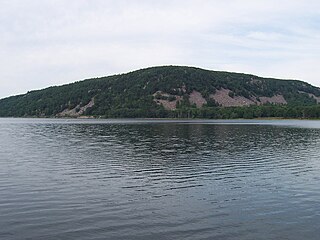
Devil's Lake is a lake in the South Range of the Baraboo Range, about two miles south of Baraboo, Wisconsin, in Sauk County, Wisconsin, United States. It has no surface outlets, so by some definitions, it is endorheic; however, it possibly drains by underground channels into the Baraboo River, which would make the lake cryptorheic. The lake is one of the primary attractions of Devil's Lake State Park. It is also a popular recreation destination for watercraft, fishing, hiking, and climbing.

<span class="mw-page-title-main">Frontenac State Park</span> State park in Minnesota, United States

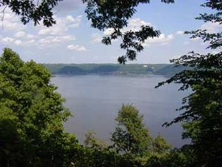
Frontenac State Park is a state park of Minnesota, United States, on the Mississippi River 10 miles (16 km) southeast of Red Wing. The park is notable both for its history and for its birdwatching opportunities. The centerpiece of the park is a 430-foot-high (130 m), 3-mile-long (4.8 km) steep limestone bluff overlooking Lake Pepin, a natural widening of the Mississippi. The bluff is variously called Garrard's Bluff or Point No-Point, the latter name coming from riverboat captains because of the optical illusion that it protruded into the Mississippi River. There is a natural limestone arch on the blufftop called In-Yan-Teopa, a Dakota name meaning "Rock With Opening". Park lands entirely surround the town of Frontenac, once a high-class resort at the end of the 19th century.

<span class="mw-page-title-main">Wildcat Mountain State Park</span> State park in Vernon County, Wisconsin

Wildcat Mountain State Park is a state park of Wisconsin, United States, on the Kickapoo River in the Driftless Area. Sandstone bluffs topped with limestone, two of which are Wildcat Mountain and Mount Pisgah, provide views over the narrow valley of the river and its tributaries. The Kickapoo Valley Reserve is immediately adjacent and forms a continuous protected area. Wildcat Mountain State Park is open for year-round recreation including hiking, canoeing, fishing, and cross-country skiing. The 3,643-acre (1,474 ha) park is located in Vernon County near the town of Ontario, Wisconsin.

<span class="mw-page-title-main">Red Hills State Park</span> State park in Lawrence County, Illinois

Red Hills State Park is an Illinois state park on 967 acres (391 ha) in Lawrence County, Illinois, United States. The park sits at an elevation of 515 feet (157 m). Red Hills State Park is open for year-round recreation including boating, fishing, hunting, hiking and various winter sports. The park includes a restaurant which is open year-round and has banquet facilities.

<span class="mw-page-title-main">Silver Mound Archeological District</span> Historic district in Wisconsin, United States

Silver Mound is a sandstone hill in Wisconsin where American Indians quarried quartzite for stone tools. Tools made from Silver Mound's quartzite have been found as far away as Kentucky. The oldest have been dated to around 11,000 years ago, so they provide clues about the first people in Wisconsin. Silver Mound Archeological District was declared a National Historic Landmark in 2006.

<span class="mw-page-title-main">Gogebic Range</span> Iron ore region in Michigan and Wisconsin

The Gogebic Range is an elongated area of iron ore deposits located within a range of hills in northern Michigan and Wisconsin just south of Lake Superior. It extends from Lake Namakagon in Wisconsin eastward to Lake Gogebic in Michigan, or almost 80 miles. Though long, it is only about a half mile wide and forms a crescent concave to the southeast. The Gogebic Range includes the communities of Ironwood in Michigan, plus Mellen and Hurley in Wisconsin.

<span class="mw-page-title-main">Potawatomi State Park</span> State park in Wisconsin, United States

Potawatomi State Park is a 1,225-acre (496 ha) Wisconsin state park northwest of the city of Sturgeon Bay, Wisconsin in the Town of Nasewaupee. It is located in Door County along Sturgeon Bay, a bay within the bay of Green Bay. Potawatomi State Park was established in 1928.

Waubeka is an unincorporated census-designated place in the Town of Fredonia, Ozaukee County, Wisconsin, United States. Located on the Milwaukee River, the community is part of the Milwaukee metropolitan area. As of the 2010 census, its population is 657.

<span class="mw-page-title-main">Frontenac, Minnesota</span> Unincorporated community in Minnesota, US

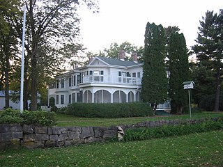
Frontenac is an unincorporated community and census-designated place (CDP) in Florence Township, Goodhue County, Minnesota, United States, on the Mississippi River. As of the 2010 census, its population was 282.

<span class="mw-page-title-main">Big Indian Farms</span> United States historic place

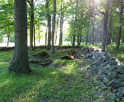
Big Indian Farms is a remote clearing in the Chequamegon Forest west of Medford, Wisconsin where as many as 130 Potawatomi and others lived from around 1896 to 1908. In this isolated spot they were able to preserve their ancestors' culture better than if they had lived under the direct influence of the Bureau of Indian Affairs on a reservation.

<span class="mw-page-title-main">Government Boarding School at Lac du Flambeau</span> United States historic place

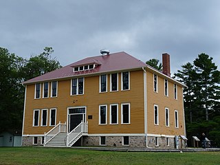
The Government Boarding School at Lac du Flambeau in Lac du Flambeau, Wisconsin was a school where Native American children of the Ojibwe, Potowatomi and Odawa peoples were taught mainstream American culture from 1895 to 1932. It served grades 1-8, teaching both academic and practical subjects, intended to give children skills needed for their rural societies. The school was converted in 1932 to a day school, serving only Ojibwe children and those nearby of other tribes.

References

  1. 1 2 "National Register of Historic Places". National Register of Historic Places. National Park Service. July 24, 2010.
  2. 1 2 "Powers Bluff County Park". Wood County. July 25, 2010.
  3. 1 2 Clayton, Lee (1991). "Pleistocene Geology of Wood County, Wisconsin". University of Wisconsin - Extension. Archived from the original on July 22, 2011. Retrieved May 22, 2011.
  4. Dott, Robert H. Jr.; Attig, John W. (2004). Roadside Geology of Wisconsin. Missoula, Montana: Mountain Press Publishing Company. p. 192.
  5. Clayton, Lee (1991). "Pleistocene Geology of Wood County - Plate 1". Information Circular 68-DI. Geological and Natural History Survey and UW Extension. Retrieved August 2, 2013.[ permanent dead link ]
  6. "Pteridophytes of Wisconsin - Botrychium mormo, goblin fern". Wisconsin Department of Natural Resources. July 26, 2010.
  7. 1 2 3 4 Jones, George O.; McVean, Norman S. (1923). History of Wood County Wisconsin. Minneapolis-Winona, Minnesota: H. C. Cooper, Jr. & Co. p. 21.
  8. 1 2 3 4 5 6 7 8 Birmingham, Robert A., "Tah-qua-kik: Continuity and Change at the Community on a Hill", retrieved 07/28/2010
  9. Article from unidentified Marshfield newspaper from 1905 or 1906, quoted by Alphonse Gerend in "History of Wood County" by Jones, McVean et al, 1923
  10. "Wood County parks in the making, 1935-1951 : a depression-born development for your leisure and recreation". November 2, 2010. Archived from the original on September 14, 2000. Retrieved November 6, 2010.
  11. Wisconsin State Journal, 10/19/2002, Susan Lampert Smith, "Skunk Hill stirs souls: Indians concerned with Wood County’s ski hill", Madison Wisc.
  12. Rued-Clark, Kris (August 5, 2023). "UWSP botanist shares love of Powers Bluff". Multi Media Channels. Stevens Point News. Retrieved August 12, 2023.
  13. Rudolph, Robert S. (1970). Wood County Place Names (PDF). The University of Wisconsin Press. p. 66.
  14. "Powers Bluff Maple Woods State Natural Area - WDNR". Wisconsin Department of Natural Resources. August 16, 2010. Archived from the original on July 13, 2010. Retrieved July 26, 2010.

Further reading