Related Research Articles
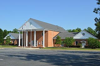
New Kent County is a county in the south eastern part the Commonwealth of Virginia. As of the 2020 United States Census, its population was 22,945. Its county seat is New Kent.
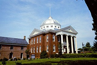
Louisa County is a county located in the Commonwealth of Virginia. As of the 2020 census, the population was 37,596. The county seat is Louisa.

Hanover County is a county in the Commonwealth of Virginia. As of the 2020 census, the population was 109,979. Its county seat is Hanover.

New Castle is the only town in Craig County, Virginia, United States. The population was 125 at the 2020 census. It is the county seat of Craig County.
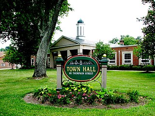
Ashland is a town in Hanover County, Virginia, United States, located 16 miles (26 km) north of Richmond along Interstate 95 and U.S. Route 1. As of the 2020 census it had a population of 7,565, up from 7,225 at the 2010 census.

Stony Creek is a town in Sussex County, Virginia, United States. The population was 198 at the 2010 census.

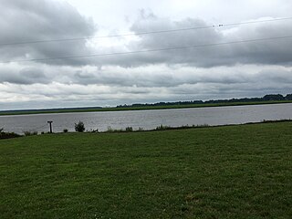
The James River is a river in Virginia that begins in the Appalachian Mountains and flows from the confluence of the Cowpasture and Jackson Rivers in Botetourt County 348 miles (560 km) to the Chesapeake Bay. The river length extends to 444 miles (715 km) if the Jackson River is included, the longer of its two headwaters. It is the longest river in Virginia. Jamestown and Williamsburg, Virginia's first colonial capitals, and Richmond, Virginia's current capital, lie on the James River.

The Pocomoke River stretches approximately 66 miles (106 km) from southern Delaware through southeastern Maryland in the United States. At its mouth, the river is essentially an arm of Chesapeake Bay, whereas the upper river flows through a series of relatively inaccessible wetlands called the Great Cypress Swamp, largely populated by Loblolly Pine, Red Maple and Bald Cypress. The river is the easternmost river that flows into Chesapeake Bay. "Pocomoke", though traditionally interpreted as "dark water" by local residents, is now agreed by scholars of the Algonquian languages to be derived from the words for "broken ground."

The Tygart Valley River — also known as the Tygart River — is a principal tributary of the Monongahela River, approximately 135 miles (217 km) long, in east-central West Virginia in the United States. Via the Monongahela and Ohio rivers, it is part of the watershed of the Mississippi River, draining an area of 1,329 square miles (3,440 km2) in the Allegheny Mountains and the unglaciated portion of the Allegheny Plateau.

Quantico Creek is a 13.7-mile-long (22.0 km) partially tidal tributary of the Potomac River in eastern Prince William County, Virginia. Quantico Creek rises southeast of Independent Hill, flows through Prince William Forest Park and Dumfries and empties into the Potomac at Possum Point.

Powhite Creek is an 8.0-mile-long (12.9 km) stream rising near the unincorporated community of Bon Air in Chesterfield County and flowing into the independent city of Richmond in central Virginia. The creek empties into the James River in the region of the Fall Line, where the rapids of the James are located upstream from the head of navigation.
Pope's Creek is a 5.3-mile-long (8.5 km) tidal tributary of the Potomac River in Westmoreland County, Virginia. The George Washington Birthplace National Monument lies along the north side of Popes Creek. Popes Creek landing is located at 38°11′29″N76°54′16″W.
The Pamunkey River is a tributary of the York River, about 93 mi (150 km) long, in eastern Virginia in the United States. Via the York River it is part of the watershed of Chesapeake Bay.

The North Anna River is a principal tributary of the Pamunkey River, about 62 miles (100 km) long, in central Virginia in the United States. Via the Pamunkey and York rivers, it is part of the watershed of Chesapeake Bay. The river was the site of the Battle of North Anna during the American Civil War.
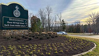
Brandermill is a major suburban residential and commercial development in the Southside of Richmond, Virginia. It is located near Midlothian, Virginia at the southern terminus of the Powhite Parkway and is centered on the Swift Creek Reservoir. The Census Bureau defines it as a Census-designated place (CDP), with a population of 13,730 as of 2020, slightly higher than its population in 2010 of 13,173.

Eagle Rock is a census-designated place (CDP) in Botetourt County, Virginia, United States, located along the James River between Iron Gate and Buchanan. It was first listed as a CDP in the 2020 census with a population of 209.
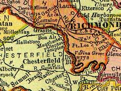
Granite was an unincorporated community in Chesterfield County, Virginia. It was originally located along the Richmond and Danville Railroad five miles west of Manchester and about a mile south of the rapids of the James River along Powhite Creek. Most of the Granite area of Chesterfield County was annexed by the independent city of Richmond on January 1, 1970.
Deep Creek is a 30.1-mile-long (48.4 km) tributary of the Appomattox River in the U.S. state of Virginia. It rises in Nottoway County northwest of Crewe 0.5 miles west of State Route 49 and flows northeast into Amelia County. SR 153, crosses Deep Creek 3.66 mi southwest of the creek's mouth. Deep Creek joins the Appomattox River 23 miles (37 km) west of Petersburg.
Flat Creek is a 34.0-mile (54.7 km) right-bank tributary of the Appomattox River in the U.S. state of Virginia. It rises just east of the town of Burkeville in Nottoway County and flows north into Amelia County, then northeast to join the Appomattox River just outside the village of Coverly 28 miles (45 km) northwest of Petersburg.
Swift Creek is a 44.9-mile-long (72.3 km) river in the U.S. state of Virginia. It rises west of Richmond in Powhatan County near U.S. Route 60 and travels southeast through Powhatan County and into Chesterfield County southwest of Hallsboro. Swift Creek flows to the north side of the Swift Creek Reservoir. After a series of twists and turns it courses into Pocahontas State Park, where it then forms Swift Creek Lake. After flowing out of Pocahontas State Park and into southeastern Chesterfield County, it eventually forms the northern boundary of Colonial Heights, where it joins the Appomattox River.
References
- ↑ "Powhite Creek". Geographic Names Information System . United States Geological Survey, United States Department of the Interior . Retrieved August 30, 2021.
- ↑ "Powhite Creek in Hanover County VA." Virginia Gazetteer. Retrieved Aug. 6, 2021.
- ↑ Gannet, Henry (1904). Gazetter of Virginia. Washington: United States Geological Survey, p. 121.
- ↑ "Powhite Creek Topo Map in Hanover County VA." Topozone. Retrieved Aug. 6, 2021.
- ↑ Harris, Malcolm Hart (1977). Old New Kent [Virginia]. Clearfield, vol. 1, p. 221.
- ↑ Sears, Stephen W. (1992). To the Gates of Richmond: The Peninsula Campaign. New York: Ticknor and Fields, pp. 217–19.