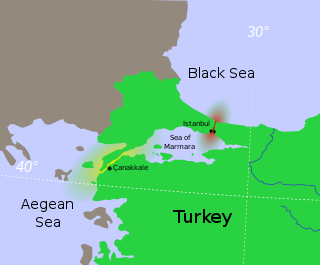
The Bosporus Strait or Bosphorus Strait is a natural strait and an internationally significant waterway located in Istanbul in northwestern Turkey that connects the Black Sea to the Sea of Marmara. It forms part of the continental boundary between Asia and Europe, and divides Turkey by separating Anatolia from Thrace. It is the world's narrowest strait used for international navigation.

The Dardanelles, also known as the Strait of Gallipoli from the Gallipoli peninsula or from Classical Antiquity as the Hellespont, is a narrow, natural strait and internationally significant waterway in northwestern Turkey that forms part of the continental boundary between Asia and Europe and separates Asian Turkey from European Turkey. Together with the Bosporus, the Dardanelles forms the Turkish Straits.

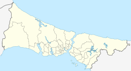
Beşiktaş is a district and municipality of Istanbul Province, Turkey. Its area is 18 km2, and its population is 175,190 (2022). It is located on the European shore of the Bosphorus strait. It is bordered on the north by Sarıyer and Şişli, on the west by Kağıthane and Şişli, on the south by Beyoğlu, and on the east by the Bosphorus. Directly across the Bosphorus is the district of Üsküdar.
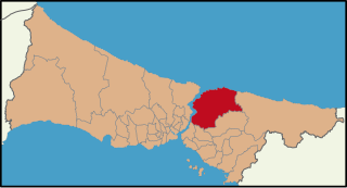
Beykoz, also known as Beicos and Beikos, is a municipality and district of Istanbul Province, Turkey. Its area is 310 km2, and its population is 247,875 (2022). It lies at the northern end of the Bosphorus on the Anatolian side. The name is believed to be a combination of the words bey and kos, which means "village" in Farsi. Beykoz includes an area from the streams of Küçüksu and Göksu to the opening of the Bosphorus into the Black Sea, and the villages in the hinterland as far as the Riva creek. The mayor is Murat Aydın (AKP).

Kladovo is a town and municipality located in the Bor District of eastern Serbia. It is situated on the right bank of the Danube river. The population of the town is 8,913, while the population of the municipality is 20,635.
İpek Şenoğlu, nicknamed İpeko, is a former Turkish tennis player.

Istanbul, formerly known as Constantinople from 330 AD until 1930 AD, is the largest city in Turkey, serving as the country's economic, cultural and historic hub. The city straddles the Bosporus strait, lying in both Europe and Asia, and has a population of over 15 million residents, comprising 19% of the population of Turkey. Istanbul is the most populous European city and the world's 15th-largest city.
The Bosphorus Bridge, known officially as the 15 July Martyrs Bridge and colloquially as the First Bridge, is the southernmost of the three suspension bridges spanning the Bosphorus strait in Istanbul, Turkey, thus connecting Europe and Asia. The bridge extends between Ortaköy and Beylerbeyi.
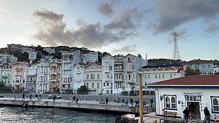
Arnavutköy is a neighbourhood in the municipality and district of Beşiktaş, Istanbul Province, Turkey. Its population is 3,574 (2022). It is renowned for its wooden Ottoman mansions and seafood restaurants, as well as for the campus of the prestigious Robert College with its historic buildings. It is part of the Beşiktaş district of Istanbul, and is located between Ortaköy and Bebek on the European shoreline of the Bosphorus strait.

İstinye is a neighbourhood in the municipality and district of Sarıyer, Istanbul Province, Turkey. Its population is 15,721 (2022). It is on the European side of the city. It is located between the neighbourhoods of Emirgan and Yeniköy, on the northwestern shore of the Bosporus strait. It is one of the finest seashore locations on the Bosporus where people walk around during the weekends. İstinye is famous for its cafés and seafood restaurants. A small bay is also among the things that make İstinye a preferred location to visit.
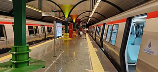
The Istanbul Metro is a rapid transit railway network that serves the city of Istanbul, Turkey. Apart from the M11 line, which is operated by TCDD Taşımacılık, the system is operated by Metro Istanbul, a public enterprise controlled by the Istanbul Metropolitan Municipality. The oldest section of the metro is the M1 line, which opened in 1989. As of April 2023, the system now includes 137 stations in service, with 56 more under construction.
The Turkish straits are two internationally significant waterways in northwestern Turkey. The straits create a series of international passages that connect the Aegean and Mediterranean seas to the Black Sea. They consist of the Dardanelles and the Bosphorus. The straits are on opposite ends of the Sea of Marmara. The straits and the Sea of Marmara are part of the sovereign sea territory of Turkey and subject to the regime of internal waters.

The Yavuz Sultan Selim Bridge, as known as Third Bridge over the Bosphorus is a bridge for rail and motor vehicle transit over the Bosphorus strait, to the north of two existing suspension bridges in Istanbul, Turkey. It was initially named the Third Bosphorus Bridge. The bridge is located near the Black Sea entrance of the Bosphorus strait, between Garipçe in Sarıyer on the European side and Poyrazköy in Beykoz on the Asian side.
Baltalimanı is a neighborhood at a bay of the European coast of Bosporus, in the Sarıyer district of Istanbul, Turkey. The name means "axe port" in Turkish.

The Istanbul Canal is a project for an artificial sea-level waterway, which is planned by Turkey in East Thrace, connecting the Black Sea to the Sea of Marmara, and thus to the Aegean and Mediterranean seas. Istanbul Canal would bisect the current European side of Istanbul and thus form an island between Asia and Europe. The new waterway would bypass the current Bosporus.
Piyalepaşa is a neighbourhood in the municipality and district of Beyoğlu, Istanbul Province, Turkey. Its population is 21,265 (2022). It is on the European Side of Istanbul. The bordering quarters are Kaptanpaşa to the south, Fetihtepe to the west, Mahmutşevketpaşa, which remains in the district of Şişli, to the east, and Mehmet Akif Ersoy, which remains in the district of Kağıthane, to the north. After Piyalepaşa was declared as a "risk area", the urban transformation project was initiated in the neighborhood.
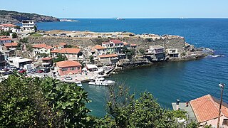
Garipçe is a neighbourhood in the municipality and district of Sarıyer, Istanbul Province, Turkey. Its population is 391 (2022).
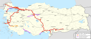
The Otoyol is the national network of controlled-access highways in Turkey. The network spans 3,633 kilometres (2,257 mi) as of 2023 and was first opened in 1973. The term Otoyol translates to motorway while the literal meaning is auto-route.

Rumelikavağı, also known as Rumeli Kavağı, is a neighbourhood in the municipality and district of Sarıyer, Istanbul Province, Turkey. Its population is 3,657 (2022). "Rumeli" is the Turkish name for Thrace, and "Kavak" means "control post" in Ottoman Turkish referring to the strategic position of the location on the Bosporus. The ferry pier which is the center of the neighborhood is at 41°10′54″N29°04′30″E.

Anadoluhisarı is a neighbourhood in the municipality and district of Beykoz, Istanbul Province, Turkey. Its population is 2,612 (2022). It is on the coast of the Bosporus Strait. It takes its name from Anadolu Hisarı fortress, built by Ottoman Sultan Bayezid the Thunderbolt in 1395 CE in preparation for the Conquest of Constantinople. Rumeli Hisarı fortress lies on the opposite shore. Kanlıca and the Fatih Sultan Mehmet Bridge lie to the north and Kandilli to the south.