Praetorium Agrippinae

Last updated
Pretoriu Agripinne depicted to the left on the Tabula Peutingeriana Peutinger Renus Patabus.png
Pretoriu Agripinne depicted to the left on the Tabula Peutingeriana

Praetorium Agrippinae was a Roman settlement in the province of Lower Germania, in the area of the Cananefates, located in modern-day Valkenburg, Netherlands. It was an army encampment (Lat.: castellum ) on the Old Rhine (at the time the major branch of the river Rhine), on the northern border of the Roman Empire, the limes. Praetorium Agrippinae is mentioned on the Tabula Peutingeriana between the castella of Matilo in the east and Lugdunum Batavorum to the west.

Contents

History

Palaeogeographic map of the Cananefatian area in the Roman period superimposed on South Holland today, showing the location of Praetorium Agrippinae. Fossa Corbulonis map.png
Palaeogeographic map of the Cananefatian area in the Roman period superimposed on South Holland today, showing the location of Praetorium Agrippinae.

Castellum

A praetorium is a military headquarters, and Praetorium Agrippinae takes its name from the mother of the emperor Caligula, Vipsania Agrippina, who died in 33 AD. It is almost certain that Caligula stayed in the area in 39 or 40 AD, since a wine barrel from his personal vineyards was found during excavations at Valkenburg. [1] Most probably, he visited the area in preparation for a never executed invasion of Britannia, and the castellum may have been erected for this operation. However, finds of coins and terra sigillata pottery suggest that Roman army units may have been stationed there before its construction. [2]

The fort was built in the current centre of Valkenburg, and was at first fortified by a palisaded earthen wall and three moats. Initially, two maniples (or four centuriae ) of legionaries and two turmae of cavalry from the cohors III Gallorum Equitata were stationed at the fort. After the Revolt of the Batavi (69–70 AD), however, when the local tribes had razed the fortress to the ground, the entire cohors IV Thracum was relocated here. Around 180 AD the Romans enlarged the fort and rebuilt it in stone. In total, seven building phases have been distinguished.

Like all other forts on the Dutch limes, Valkenburg was deserted after the collapse of the Roman border defense around 275 AD. Valkenburg, however, is one of the few castella where evidence for Late Roman building activities was found. During the reign of Constantius I Chlorus a granary was constructed here for the shipment of grain to Britannia. [3]

Vicus

To the southeast of the fortress, a large civil settlement ( vicus ) developed, stretching for approx. 1 km along the via militaris. It was inhabited between approx. 70 and 240 AD. [4] Archaeological investigations have uncovered living quarters, storehouses and granaries, and possibly a bath house. A large cemetery containing over 700 graves was found as well. Between 70 and 110 AD, a small military encampment ("mini-castellum") was located here as well. [5]

Reconstruction of the Roman road at Valkenburg Valkenburg - N206 - Romeinse weg.jpg
Reconstruction of the Roman road at Valkenburg

Remains

Some of the finds can be seen in the Torenmuseum in Valkenburg. On the central square of town, the Castellumplein, the contours of the fort are visualised with bronze dots in the pavement. The foundations of one of the fort's gates have been reconstructed as well. Outside town, on the N206 provincial road, a reconstruction of the military road can be seen.

Excavations

Valkenburg is one of the best excavated Roman sites in the Netherlands. Investigations started in 1875, but the main excavations were done between 1941 and 1953 under the direction of Albert Egges van Giffen. [6] [7] [8] [9] These excavations yielded large quantities of finds, and since the remains of the castellum were found below groundwater level, they were very well preserved and included many organic remains, such as foodstuffs, bone, leather [10] and rope. This allowed for detailed reconstruction of Roman building practices and feeding habits.

In the 1970s and 1980s, further excavations were done in the area of the vicus. A recent re-analysis showed that the houses here were built in narrow rectangular parcels, perpendicular to the military road. [11]

Related Research Articles

<span class="mw-page-title-main">Woerden</span> City and Municipality in Utrecht, Netherlands

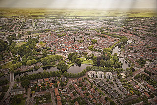
Woerden (Dutch pronunciation:

<span class="mw-page-title-main">Castra</span> Roman term for a fortified military base

In the Roman Republic and the Roman Empire, the Latin word castrum, was a military-related term.

<span class="mw-page-title-main">Oude Rijn (Utrecht and South Holland)</span> River in Netherlands

The Oude Rijn is a branch of the Rhine delta in the Dutch provinces of Utrecht and South Holland, starting west of Utrecht, at Harmelen and runs by a mechanical pumping station into the North Sea at Katwijk. Its present-day length is 52 kilometres.

The Latin term praetorium originally identified the tent of a general within a Roman castrum (encampment), and derived from the title praetor, which identified a Roman magistrate. Originally, Praetor ("leader") was the title of the ranking civil servant in the Roman Republic, but later identified a rank of office below the rank of consul.

The Limes Arabicus was a desert frontier of the Roman Empire, running north from its start in the province of Arabia Petraea. It ran northeast from the Gulf of Aqaba for about 1,500 kilometers (930 mi) at its greatest extent, reaching northern Syria and forming part of the wider Roman limes system. It had several forts and watchtowers.

<span class="mw-page-title-main">Flevum</span>

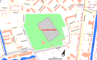
Flevum was a castrum and port of the Romans in Frisia, built when emperor Augustus wanted to conquer the German populated territories between the Rhine river and the Elbe river.

<span class="mw-page-title-main">Pons Aelius</span> Roman settlement in northern England

Pons Aelius, or Newcastle Roman Fort, was an auxiliary castra and small Roman settlement on Hadrian's Wall in the Roman province of Britannia Inferior, situated on the north bank of the River Tyne close to the centre of present-day Newcastle upon Tyne, and occupied between the 2nd and 4th centuries AD.

<span class="mw-page-title-main">Castleshaw Roman Fort</span> Roman camp in Greater Manchester, England

Castleshaw Roman fort was a castellum in the Roman province of Britannia. Although there is no evidence to substantiate the claim, it has been suggested that Castleshaw Roman fort is the site of Rigodunum, a Brigantian settlement. The remains of the fort are located on Castle Hill on the eastern side of Castleshaw Valley at the foot of Standedge but overlooking the valley. The hill is on the edge of Castleshaw in Greater Manchester. The fort was constructed in c. AD 79, but fell out of use at some time during the 90s. It was replaced by a smaller fortlet, built in c. 105, around which a civilian settlement grew. It may have served as a logistical and administrative centre, although it was abandoned in the 120s.

<span class="mw-page-title-main">Regulbium</span> Roman fort in Kent, England

Regulbium was the name of an ancient Roman fort of the Saxon Shore in the vicinity of the modern English resort of Reculver in Kent. Its name derives from the local Brythonic language, meaning "great headland" (*Rogulbion).

<span class="mw-page-title-main">Fectio</span> Former Roman castellum, village in Netherlands

Fectio, known as Vechten in Old Dutch, was a Roman castellum in the province Germania Inferior established in the year 4 or 5 AD. It was located at the place where the river Vecht (Fectio) branched off from the Rhine, leading to Lake Flevo, which was later to become the Zuiderzee. This was near the modern hamlet of Vechten in the municipality Bunnik, Utrecht, Netherlands.

<span class="mw-page-title-main">Brittenburg</span> Roman fort west of Leiden (now in the sea)

Brittenburg was a Roman ruin site west of Leiden between Katwijk aan Zee and Noordwijk aan Zee, presumably identical to the even older Celtic Lugdunum fortress. The site is first mentioned in 1401, was uncovered more completely by storm erosion in 1520, 1552 and 1562, and has subsequently been entirely eroded away. When built, it was located at the mouth of the Oude Rijn, which has since moved. The site was about a kilometre west of the European Space Research and Technology Centre, now offshore in the North Sea).

Calceology is the study of footwear, especially historical footwear whether as archaeology, shoe fashion history, or otherwise. It is not yet formally recognized as a field of research. Calceology comprises the examination, registration, research and conservation of leather shoe fragments. A wider definition includes the general study of the ancient footwear, its social and cultural history, technical aspects of pre-industrial shoemaking and associated leather trades, as well as reconstruction of archaeological footwear.

<span class="mw-page-title-main">Netherlands in the Roman era</span>

For around 450 years, from around 55 BC to around 410 AD, the southern part of the Netherlands was integrated into the Roman Empire. During this time the Romans in the Netherlands had an enormous influence on the lives and culture of the people who lived in the Netherlands at the time and (indirectly) on the generations that followed.

<span class="mw-page-title-main">Matilo</span> Former Roman fort in Netherlands

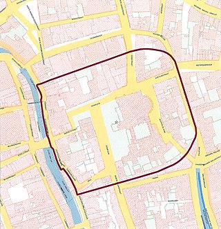
Matilo or Matilone was once a Roman fort (castellum) in modern-day Leiden. Positioned on the southern banks of the Oude Rijn, it served to protect the Roman borders in the province of Germania Inferior. On the Peutinger map, it lies between the encampments of Albaniana and Praetorium Agrippinae (Valkenburg). The seventh-century Ravenna Cosmography gives its name as Matellionem.

Albaniana was the name the ancient Romans gave a settlement on the southern banks of Rhine river, some 40 kilometers from its mouth in the North Sea, known as Alfen and modern-day Alphen aan den Rijn, Netherlands. They did build a military fort there, as part of a range strategically built encampments, to protect and guard the river, frontier (limes) of the Roman empire and main transport route of goods and troops. The historical map Tabula Peutingeriana situates the settlement in between Matilo (Leiden) and Praetorium Agrippinae (Valkenburg) downstream and Nigrum Pullum (Zwammerdam) and Fectio (Vechten) upstream. The village was mentioned in Antoninus' register of roads Itinerarium Antonini from the 3rd century. The fortress must have been surrounded by a wall of ground and wooden poles, with gates and watch towers.

<span class="mw-page-title-main">Traiectum (Utrecht)</span> Former Roman fort in The Netherlands

Traiectum was a Roman fort, on the frontier of the Roman Empire in Germania Inferior. The remains of the fort are in the center of Utrecht, Netherlands, which takes its name from the fort.

<span class="mw-page-title-main">Basilica of Our Lady, Tongeren</span> Church in Tongeren, Belgium

The Basilica of Our Lady, also called Old Cathedral of Tongeren, is the main place of Catholic worship in Tongeren, Belgium, and the former cathedral of the suppressed diocese of Tongeren.

<span class="mw-page-title-main">Rede van Texel</span>

The Rede van Texel, formerly Reede van Texel, was a roadstead off the Dutch island of Texel. It was of considerable importance to Dutch long-distance shipping between roughly 1500 and 1800. The Rede van Texel was located off the east side of the island, near the town of Oudeschild.

<span class="mw-page-title-main">Jaap Renaud</span> Dutch university teacher

Jacob Gerard Nicolaas (Jaap) Renaud was a Dutch archaeologist and Adjunct professor at Utrecht University.

<span class="mw-page-title-main">Carbatina</span> Ancient type of rustic footwear

The carbatina was a kind of shoe common among the rural poor of ancient Greece and Rome from remote antiquity to around the 3rd century, consisting of a piece of rawhide pulled around the foot and then tied down to hold it in place. Having no upper or separate sole, the carbatina is among the simplest forms of footwear in the world and is sometimes used as a general name for similar footwear in other cultures.

References

  1. S. Wynia 1999. "Caius was here. The Emperor Caius' Preparations for the Invasion of Britannia: New Evidence" in: H. Sarfatij, W.J.H. Verwers & P.J. Woltering (eds.), In Discussion with the Past. Archaeological studies presented to W.A. van Es . Zwolle, SPA Foundation, pp. 145-147
  2. (in Dutch)A.E. De Hingh, W.K. Vos 2005. Romeinen in Valkenburg (ZH), de opgravingsgeschiedenis en het archeologische onderzoek van Praetorium Agrippinae. Leiden, Hazenberg Archeologie
  3. W. Groenman-van Waateringe 1977. Grain storage and supply in the Valkenburg castella and Praetorium Agrippinae, in: B.L. van Beek, R.W. Brandt & W. Groenman-van Waateringe (eds.) Ex Horreo. IPP 1951-1976. Amsterdam, IPP, pp. 226-241
  4. (in Dutch)A.E. De Hingh, W.K. Vos 2005. Romeinen in Valkenburg (ZH), de opgravingsgeschiedenis en het archeologische onderzoek van Praetorium Agrippinae. Leiden, Hazenberg Archeologie
  5. W. Groenman-van Waateringe 1986. Valkenburg Marktveld: military and civilian occupation in the vicinity of a Roman fort, in: C. Unz (ed.) Studien zu den Militärgrenzen Roms III. 13. Internationaler Limeskongreß Aalen 1983. Vorträge. Stuttgart, Theiss, pp. 159-168
  6. (in Dutch)A.E. van Giffen 1948. "De Romeinsche castella in de dorpsheuvel te Valkenburg aan den Rijn (Z.H.) (Praetorium Agrippinae), I, De opgravingen in 1941". Jaarverslag van de Vereniging voor Terpenonderzoek 25-28 (1940-1944)
  7. (in Dutch)A.E. van Giffen 1955. "De Romeinsche castella in de dorpsheuvel te Valkenburg aan den Rijn (Z.H.) (Praetorium Agrippinae), II, De opgravingen in 1942-1943 en 1946-1950". Jaarverslag van de Vereniging voor Terpenonderzoek 33-37 (1948-1953)
  8. (in Dutch)W. Glasbergen 1967. De Romeinse castella te Valkenburg Z.H. De opgravingen in de dorpsheuvel in 1962. Groningen, Wolters-Noordhoff
  9. (German)S.M.E. van Lith 1979. "Römisches Glas aus Valkenburg Z.H." OMROL 59/60, pp. 1-150
  10. (in Dutch)W. Groenman-van Waateringe 1967. Romeins lederwerk uit Valkenburg Z.H. Groningen, Wolters
  11. (in Dutch)W.K. Vos, E. van der Linden & B. Voormolen 2012. Romeinen op de Woerd, Reconstructie van een woonwijk op grond van een vergeten opgraving in Valkenburg (ZH). Leiden, Hazenberg Archeologie

52°10′47″N4°25′54″E / 52.1797°N 4.4317°E / 52.1797; 4.4317