Related Research Articles

Termini Imerese is a town of the Metropolitan City of Palermo on the northern coast of Sicily, in Italy. It is one of the most important towns of the Metropolitan City of Palermo, from which it is 33 km away. The town is easily reachable through its well developed infrastructures: there are three highway exits along the A19, its station is the meeting point between all of the Sicilian railway lines and its seaport links the town with other important maritime Italian cities. It has a judicial district. It's culturally interesting for the close Greek ruins of Himera, its numerous churches, Roman ruins, prehistorical finds and the annual celebration of the Carnival, one of the oldest of Italy. In the heart of the old town, at its lower level, there are the thermal baths of the Grand Hotel delle Terme, where precious hot waters flow since Roman age. In the areas of Termini and the near Sciara and Caccamo there's the Oriented Nature Reserve of Mount St. Calogero, which is located between the coast of Termini Imerese Gulf and the surrounding fertile flat territory. In the east zone of the town, there's an important industrial area, especially known for the former factory which was owned by FIAT and for the ENEL power plant “Ettore Majorana”.

The Aequi were an Italic tribe on a stretch of the Apennine Mountains to the east of Latium in central Italy who appear in the early history of ancient Rome. After a long struggle for independence from Rome, they were defeated and substantial Roman colonies were placed on their soil. Only two inscriptions believed to be in the Aequian language remain. No more can be deduced than that the language was Italic. Otherwise, the inscriptions from the region are those of the Latin-speaking colonists in Latin. The colonial exonym documented in these inscriptions is Aequi and also Aequicoli. The manuscript variants of the classical authors present Equic-, Aequic-, Aequac-. If the form without the -coli is taken as an original, it may well also be the endonym, but to date further evidence is lacking.
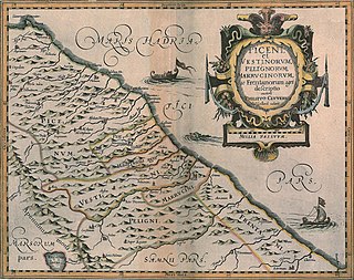
Vestini were an Italic tribe who occupied the area of the modern Abruzzo, included between the Gran Sasso and the northern bank of the Aterno river. Their main centres were Pitinum (near modern L'Aquila), Aufinum (Ofena), Peltuinum, Pinna (Penne) and Aternum (Pescara, shared with the Marrucini).
Sulci or Sulki, was one of the most considerable cities of ancient Sardinia, situated in the southwest corner of the island, on a small island, now called Isola di Sant'Antioco, which is, however, joined to the mainland by a narrow isthmus or neck of sand. South of this isthmus, between the island and the mainland, is an extensive bay, now called the Golfo di Palmas, which was known in ancient times as the Sulcitanus Portus (Ptol.).

The Senones or Senonii were an ancient Gallic tribe dwelling in the Seine basin, around present-day Sens, during the Iron Age and the Roman period.

The Aulerci Cenomani were a Gallic tribe dwelling in the modern Sarthe department during the Iron Age and the Roman period. The Cenomani were the most powerful of the Aulerci tribes.
Compsa was an ancient city of the Hirpini, near the sources of the Aufidus, on the boundary of Lucania and not far from that of Apulia, on a ridge 609 m above sea level. It was betrayed to Hannibal in 216 BC after the defeat of Cannae, but recaptured two years later. It was probably occupied by Sulla in 89 BC, and was the scene of the death of Titus Annius Milo in 48 BC.

Latium adiectum or Latium Novum was a region of Roman Italy between Monte Circeo and the river Garigliano, south of and immediately adjacent to Old Latium, hence its name of attached Latium.
Usellus is a town, comune (municipality) and former bishopric in the Province of Oristano in the Italian region Sardinia.

The Frentani were an Italic tribe occupying the tract on the southeast coast of the Italian peninsula from the Apennines to the Adriatic, and from the frontiers of Apulia to those of the Marrucini. They were bounded on the west by the Samnites, with whom they were closely connected, and from whom they were originally descended. Hence Scylax assigns the whole of this line of coast, from the frontiers of Apulia to those of Picenum, to the Samnites. Their exact limits are less clearly defined, and there is considerable discrepancy in the statements of ancient geographers: Larinum, with its territory, being by some writers termed a city of the Frentani, while the more general opinion included it in Apulia, and thus made the river Tifernus the limit of the two countries. The northern boundary of the Frentani is equally uncertain; both Strabo and Ptolemy concur in fixing it at the river Sagrus, while Pliny extends their limits as far as the Aternus, and, according to Mela, they possessed the mouths both of that river and the Matrinus. The latter statement is certainly inaccurate; and Strabo distinctly tells us that the Marrucini held the right bank of the Aternus down to its mouth, while the Vestini possessed the left bank; hence, the former people must have intervened between the Frentani and the mouth of the Aternus. Pliny's account is, however, nearer the truth than that of Strabo and Ptolemy; for it is certain that Ortona and Anxanum, both of which are situated considerably to the north of the Sagrus, were Frentanian cities. The latter is indeed assigned by Ptolemy to that people, while Strabo also terms Ortona the port or naval station of the Frentani, but erroneously places it to the south of the river Sagrus. Hence, their confines must have approached within a few miles of the Aternus, though without actually abutting upon that river. On the west, they were probably not separated from the Samnites by any well-marked natural boundary, but occupied the lower slopes of the Apennines as well as the hilly country extending from thence to the sea, while the more lofty and central ridges of the mountains were included in Samnium.

San Benedetto dei Marsi is a comune and town in the province of L'Aquila in the Abruzzo region of central Italy. It is on the eastern shore of the dried Lake Fucino, 20 kilometres (12 mi) from the remains of another ancient site, Alba Fucens.
Atri is a comune in the Province of Teramo in the Abruzzo region of Italy. Atri is the setting of the poem The Bell of Atri by American writer Henry Wadsworth Longfellow. Its name is the origin of the name of the Emperor Hadrian, whose family came from the town.

Serica was one of the easternmost countries of Asia known to the Ancient Greek and Roman geographers. It is generally taken as referring to North China during its Zhou, Qin, and Han dynasties, as it was reached via the overland Silk Road in contrast to the Sinae, who were reached via the maritime routes. A similar distinction was later observed during the Middle Ages between "Cathay" (north) and "Mangi" or "China" (south). The people of Serica were the Seres, whose name was also used for their region. Access to Serica was eased following the Han conquest of the Tarim Basin but largely blocked when the Parthian Empire fell to the Sassanids. Henry Yule summarized the classical geographers:
If we fuse into one the ancient notices of the Seres and their country, omitting anomalous statements and manifest fables, the result will be something like the following:—"The region of the Seres is a vast and populous country, touching on the east the Ocean and the limits of the habitable world, and extending west to Imaus and the confines of Bactria. The people are civilized, mild, just, and frugal, eschewing collisions with their neighbours, and even shy of close intercourse, but not averse to dispose of their own products, of which raw silk is the staple, but which include also silk-stuffs, fine furs, and iron of remarkable quality." That is manifestly a definition of the Chinese.

Neapolis meaning "New City", was an ancient city of Sardinia founded by the Carthaginians in the sixth century BC, and apparently one of the most considerable places on that island. It was situated on the west coast, at the southern extremity of the Gulf of Oristano, at the present-day località of Santa Maria di Nabui, in the comune of Guspini, Province of Medio Campidano.

Trebula or Trebula Balliensis or Trebula Baliensis, was an ancient city of Campania, Italy, the location of which is occupied by the modern village of Treglia in the comune of Pontelatone. The Monti Trebulani, a small mountain group in the modern province of Caserta, take their name from it.
Imachara, was an ancient city of Sicily repeatedly mentioned by Cicero among the municipal towns of the island. There is great discrepancy in regard to the form of the name, which is written in many manuscripts Macarēnsis or Macharēnsis; and the same uncertainty is found in those of Pliny, who also notices the town among those of the interior of Sicily. The precise location of Imachara is not known but has been and remains the subject of much scholarly debate. Even though Mirabella Imbaccari is still named in Sicilian as Màcara and its inhabitants are called macarisi, both deriving incontrovertibly from their corrispective Latin ascendants.
Hybla Gereatis, was an ancient city of Magna Graecia in Sicily, located on the southern slope of Mount Etna, not far from the river Symaethus, in the modern comune of Paternò. There were at least three cities named "Hybla" in ancient accounts of Sicily which are often confounded with each other, and which it is sometimes very difficult to distinguish.
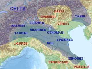
The Cenomani, was an ancient tribe of the Cisalpine Gauls, who occupied the tract north of the Padus, between the Insubres on the west and the Veneti on the east. Their territory appears to have extended from the river Addua to the Athesis.
The Tyrageti, Tyragetae, or Tyrangitae, literally, the Getae of the Tyras, were a sub-tribe of the Getae, situated on the river Tyras. They were regarded as an immigrant tribe of European Sarmatia dwelling east of the river Tyras, near the Carpii and Tagri, and, according to Ptolemy, the northern neighbours of Lower Moesia. Pliny calls them, with more correct orthography, Tyragetae, and represents them as dwelling on a large island in the Tyras.
Milyas was a mountainous country in ancient south-west Anatolia. However, it is generally described as being mostly in the northern part of the successor kingdom of Lycia, as well as southern Pisidia, and part of eastern Phrygia. According to Herodotus, the boundaries of Milyas were never fixed.
References
- ↑ "Abruzzo History III". Archived from the original on 2011-07-08. Retrieved 2009-03-08.
- ↑ Pol. iii. 88; Liv. xxii. 9, xxvii. 43; Plin. iii. 13. s. 18; Ptol. iii. 1. § 58.
- ↑ Blondi Flavii, Italia Illustrata, p. 394.
- ↑ Ptol. l. c.
- ↑ "Ager Praetutianus Palmensisque", Plin. l. c..
- ↑ Plin. xiv. 6. s. 8; Dioscor. v. 19; Silius Italicus xv. 568.
 This article incorporates text from a publication now in the public domain : Smith, William, ed. (1854–1857). Dictionary of Greek and Roman Geography . London: John Murray.
{{cite encyclopedia}}: Missing or empty|title=(help)- This article incorporates text from a publication now in the public domain : Chisholm, Hugh, ed. (1911). "Praetuttii". Encyclopædia Britannica . Vol. 22 (11th ed.). Cambridge University Press. p. 246.
| Authority control databases: Geographic |
|---|