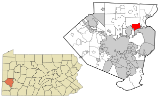
Harmar Township is a township in Allegheny County, Pennsylvania, United States. The population was 2,921 at the 2010 census.

Lake Stickney is a census-designated place (CDP) in Snohomish County, Washington, United States. The population was 7,777 at the 2010 census. The CDP was known as Paine Field-Lake Stickney prior to 2010. The new Lake Stickney CDP no longer contains the Paine Field airport.

Marietta-Alderwood is a census-designated place (CDP) in Whatcom County, Washington, United States. The population was 3,906 at the 2010 census. Parts of Marietta-Alderwood became part of Bellingham in 2019 through the process of annexation
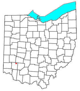
Crosswick is an unincorporated community in central Wayne Township, Warren County, Ohio, United States, located just outside Waynesville.

Pittsburg is an unincorporated community in Fayette County, Illinois, United States. Located at 38°52′17″N89°12′42″W, it lies at an elevation of 531 feet. It was named after the industrial heritage of Pittsburgh, Pennsylvania which, coincidentally, has a Fayette County, Pennsylvania as part of its metropolitan area.

Albina is a historical American city that was consolidated into Portland, Oregon in 1891.
The Whitefish River is an 11.9-mile-long (19.2 km) river on the Upper Peninsula of the U.S. state of Michigan. The mouth of the river is in Delta County at 45°54′34″N86°58′01″W on the Little Bay De Noc of Lake Michigan. The main branch of the river is formed by the confluence of the east and west branches at 46°03′25″N86°52′17″W.

Ballyedmond is a village in the southeastern corner of Ireland. It is situated in County Wexford on the R741 regional road.

Janney is an unincorporated community in Washington Township, Delaware County, Indiana.
Żakowola Stara is a village in the administrative district of Gmina Kąkolewnica Wschodnia, within Radzyń Podlaski County, Lublin Voivodeship, in eastern Poland.

WMLP is a commercial AM radio station licensed to serve Milton, Pennsylvania. The station is owned by Sunbury Broadcasting Corporation and broadcasts a conservative talk radio format.

Mearns is a hamlet in central Alberta, Canada within Sturgeon County. It is located approximately 11 kilometres (6.8 mi) west of Highway 2 and 31 kilometres (19 mi) northwest of Edmonton's city limits.
Stony Mill is an unincorporated community in Pittsylvania County, in the U.S. state of Virginia.
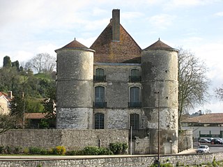
Château de Montréal (Peyrehorade), also known as château d'Orthe, is a château in the commune of Peyrehorade, Landes, Nouvelle-Aquitaine, France. It dates to the 16th century and is a national historical monument.
Clare is an unincorporated community in Johnson County, Kansas, United States. Clare is located at 38°49′37″N94°52′17″W.
Fawn is an unincorporated community in Dent County, in the U.S. state of Missouri.

Ranchitos del Norte is a census-designated place (CDP) in Starr County, Texas, United States. It is a new CDP for the 2010 census with a population of 112. Parts of this new CDP were formed from the former Los Villareales CDP.
Cradick Corner is an unincorporated community in Warren Township, Putnam County, in the U.S. state of Indiana.
Tordillo Mountain is a lone summit that rises to the elevation of 2,064 feet / 629 meters in Yuma County, Arizona.


