
Malvik is a municipality in Trøndelag county, Norway. It is part of the Trondheim Region. The administrative center of the municipality is the village of Hommelvik. Other villages in Malvik include Muruvika, Smiskaret, Sneisen, Vikhammer, and Hundhammeren.

Selbu is a municipality in Trøndelag county, Norway. The administrative centre of the municipality is the village of Mebonden. Other villages in Selbu include Flora, Fossan, Hyttbakken, Innbygda, Selbustrand, Trøa, Tømra, and Vikvarvet.
Meråker is a municipality in Trøndelag county, Norway. It is part of the Stjørdalen region. The administrative centre of the municipality is the village of Midtbygda which is about 20 kilometres (12 mi) west of Storlien in Sweden and 46 kilometres (29 mi) east of the town of Stjørdalshalsen in neighboring Stjørdal municipality. Other villages in Meråker include Gudåa, Kopperå, and Stordalen.

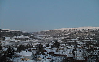
Hegra is a village in the municipality of Stjørdal in Trøndelag county, Norway. The village is located in the Stjørdalen valley, about 10 kilometres (6.2 mi) east of the town of Stjørdalshalsen along the Stjørdalselva river and it is therefore a good site for fishing. The 0.41-square-kilometre (100-acre) village has a population (2018) of 524 and a population density of 1,278 inhabitants per square kilometre (3,310/sq mi).

Stjørdalen is a valley and a traditional district in Trøndelag county, Norway. The valley follows the river Stjørdalselva river from the border with Sweden 75 kilometres (47 mi) to the west where it empties into the Trondheimsfjorden. The valley traverses the present-day municipalities of Stjørdal and Meråker. The European route E14 highway and the Meråker Line railway follow the river through the length of the valley.
Skatval is a village in the municipality of Stjørdal in Trøndelag county, Norway. It is located on the Skatval peninsula about 8 kilometres (5.0 mi) northwest of the town of Stjørdalshalsen. The inhabitants are called as Skatvalsbygg. Skatval Church is located in the village.
Kvithammer or Kvithammar is a village in the Skatval area of the municipality of Stjørdal in Trøndelag county, Norway. It is located in the western part of the municipality, about 3 kilometres (1.9 mi) northwest of the town of Stjørdalshalsen. The 0.13-square-kilometre (32-acre) village has a population (2018) of 216 and a population density of 1,662 inhabitants per square kilometre (4,300/sq mi).
Øvre Stjørdal or Øvre Stjørdalen is a former municipality in the old Nordre Trondhjem county in Norway. The 1,913-square-kilometre (739 sq mi) municipality existed from 1850 until its dissolution in 1874. The municipality encompassed the upper part of the Stjørdalen valley which includes what is now the municipality of Meråker and the Hegra area of the municipality of Stjørdal, both in Trøndelag county. The administrative centre of the municipality was the village of Hegra where the Hegra Church is located.
Nedre Stjørdal or Nedre Stjørdalen is a former municipality in the old Nord-Trøndelag county in Norway. The municipality existed from 1850 until its dissolution in 1902. The 340-square-kilometre (130 sq mi) municipality covered the western part of what is now the municipality of Stjørdal in Trøndelag county. The administrative centre was located at Værnes where Værnes Church is located.
Feren or Færen is a lake in the municipality of Meråker in Trøndelag county, Norway. A small part in the northwestern corner of the lake extends into the municipalities of Stjørdal, Levanger, and Verdal at the outlet into the river Forra. The 26-square-kilometre (10 sq mi) lake lies about 14 kilometres (8.7 mi) north of the municipal center of Midtbygda, about 2.5 kilometres (1.6 mi) north of the lake Funnsjøen, and about 8 kilometres (5.0 mi) north of the lake Fjergen.

Lånke was a former municipality in the old Nord-Trøndelag county, Norway. The 185-square-kilometre (71 sq mi) municipality existed from 1902 until its dissolution in 1962. The municipality was located south of the Stjørdalselva river in what is now the south-central part of Stjørdal municipality in Trøndelag county. The administrative centre was located in the village of Hell. The famous Hell Station in the village of Hell is situated in the westernmost part of Lånke. There are two churches in Lånke: Lånke Church and Elvran Chapel. Historically, this parish was also known as Leksdal. Lånke is an area dominated by agriculture and forests.

Stjørdalshalsen is a town and the administrative centre of the municipality of Stjørdal in Trøndelag county, Norway. It is located between the rivers Stjørdalselva and Gråelva to the south and north and by the Trondheimsfjord to the west.
Værnes is an area in the municipality of Stjørdal in Trøndelag county, Norway. It is located in the western part of the municipality, about 3 kilometres (1.9 mi) southeast of the town of Stjørdalshalsen and just northeast of the Stjørdalselva river delta. The village of Hell/Lånke lie to the south, and the village of Prestmoen lies to the east.
Skjelstadmarka is a village in the municipality of Stjørdal in Trøndelag county, Norway. It is located in the central part of the municipality, about 12 kilometres (7.5 mi) northeast of the town of Stjørdalshalsen, about 5 kilometres (3.1 mi) north of the village of Hegra, and about 10 kilometres (6.2 mi) east of the mountain Forbordsfjellet. The village is the location of Okkelberg Chapel.

Værnes Church is a parish church of the Church of Norway in Stjørdal municipality in Trøndelag county, Norway. It is located in the village of Prestmoen, just south of the town of Stjørdalshalsen. It is located along the Stjørdalselva river, just east of the Trondheim Airport, Værnes. It is the church for the Stjørdal parish which is part of the Stjørdal prosti (deanery) in the Diocese of Nidaros. The white, stone church was built in a long church style around the year 1100 by an unknown architect. The church seats about 320 people.
Stjørdalen is a former municipality in the old Nordre Trondhjem county in Norway. The 2,253-square-kilometre (870 sq mi) municipality existed from 1838 until its dissolution in 1850. The municipality covered the whole Stjørdalen valley in what is now the municipalities of Stjørdal and Meråker in Trøndelag county. The administrative centre was located at Værnes where Værnes Church is located.

Hegra is a former municipality in the old Nord-Trøndelag county, Norway. The 612-square-kilometre (236 sq mi) municipality existed from 1874 until its dissolution in 1962. The municipality was located in the Stjørdalen valley. It encompassed the eastern two-thirds of the what is now the municipality of Stjørdal in Trøndelag county. The administrative centre was the village of Hegra where the Hegra Church is located.

Skatval is a former municipality in the old Nord-Trøndelag county, Norway. The 94-square-kilometre (36 sq mi) municipality existed from 1902 until its dissolution in 1962. The municipality encompassed the Skatval peninsula in the northwestern part of what is now the municipality of Stjørdal in Trøndelag county. The administrative centre was the village of Skatval where the Skatval Church is located. Other villages in the Skatval area include Auran, Kvithammer, and Steinvika.


