
The Regional Municipality of Durham, informally referred to as Durham Region, is a regional municipality in Southern Ontario, Canada. Located east of Toronto and the Regional Municipality of York, Durham forms the east-end of the Greater Toronto Area and part of the Golden Horseshoe region. It has an area of approximately 2,500 km2 (970 sq mi). The regional government is headquartered in Whitby.

Walkerton is a Town in the Canadian province of Ontario, located within and governed by the municipality of Brockton. It is the site of Brockton's municipal offices and the county seat of Bruce County. It is located on the Saugeen River, at the junction of King's Highway 9 and formerly King's Highway 4 and is 75 km southwest of Owen Sound. As of 2011, the town had 4,967 people in the community.

Scugog is a township in the Regional Municipality of Durham, south-central Ontario, Canada. It is northeast of Toronto and just north of Oshawa. The anchor and largest population base of the township is Port Perry. The township has a population of roughly 22,500. A smaller Scugog Township was also a historic municipality and geographic township prior to the amalgamation that formed the current municipality.
West Grey is a township in the northern area of Southwestern Ontario, Canada, in Grey County spanning across the River Styx, the Rocky Saugeen River, the Beatty Saugeen River, and the South Saugeen River.

The Saugeen River is located in southern Ontario, Canada. The river begins in the Osprey Wetland Conservation Lands and flows generally north-west about 160 kilometres (99 mi) before exiting into Lake Huron. The river is navigable for some distance, and was once an important barge route. Today the river is best known for its fishing and as a canoe route.

Wingham is a community located in the municipality of North Huron, Ontario, Canada, which is located in Huron County. Wingham became part of North Huron in 2001 when the Ontario government imposed amalgamation on the former township of East Wawanosh, the village of Blyth, and the town of Wingham.

Bradford is the primary country urban area of the Town of Bradford West Gwillimbury, Ontario, in Canada. It overlooks a farming community, known as The Holland Marsh, located on the Holland River that flows into Lake Simcoe.

Oro-Medonte is a township in south-central Ontario, Canada, on the northwestern shores of Lake Simcoe in Simcoe County.

Southampton is a community on the shores of Lake Huron in Bruce County, Ontario, Canada, and close to Port Elgin. It is located at the mouth of the Saugeen River in the Saugeen Ojibway Nation Territory. The size of the town is 6.44 square kilometres. The permanent population in 2016 was 3,678 but the summer population is higher, due to cottagers and campers spending vacation time in the area.

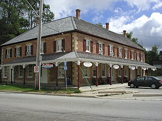
Hanover is a town in the Canadian province of Ontario with a population of about 7,650 residents. It is located in southwestern Grey County, bordering on Bruce County, west of Durham and east of Walkerton on Grey/Bruce Road 4. Hanover has a city hall, police department and the Hanover and District Hospital.

Markdale is a community in the Municipality of Grey Highlands, in Grey County, Ontario, Canada. The population was 1,216 in 2016, an increase of 3.5% from 1,175 in 2011. In 2016, the average age of the population was approximately 43 years old.
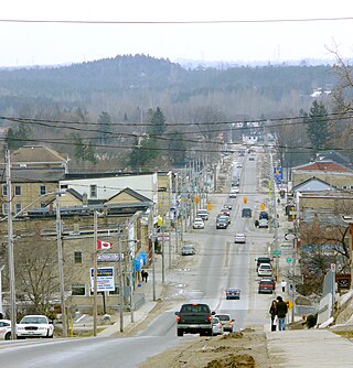
Durham is a community in the municipality of West Grey, Grey County, Ontario, Canada. Durham is located near the base of the Bruce Peninsula.
King's Highway 9, commonly referred to as Highway 9, is a provincially maintained highway in the Canadian province of Ontario. Highway 9 has been divided into two segments since January 1, 1998, when the segment between Harriston and Orangeville was downloaded to the various counties in which it resided. The western segment of the highway begins at Highway 21 in Kincardine, near the shores of Lake Huron. It travels 73 km (45 mi) to the junction of Highway 23 and Highway 89 in Harriston. The central segment is now known as Wellington County Road 109 and Dufferin County Road 109. At Highway 10 in Orangeville, Highway 9 resumes and travels east to Highway 400. The highway once continued east to Yonge Street in Newmarket, but is now known as York Regional Road 31.
Nairn and Hyman is a township in the Canadian province of Ontario. The township, located in the Sudbury District, borders on the southwestern city limits of Greater Sudbury west of the city's Walden district. The township had a population of 342 in the Canada 2016 Census.
Flesherton is a community in the Municipality of Grey Highlands, in Grey County, Ontario, Canada, located at the junction of Highway 10 and Grey County Road 4. Although the area initially showed a high rate of growth in the 1850s and its founder believed that it would become an important centre of economic activity, growth stagnated when an all-important rail link bypassed it, and the community never grew larger than a small village. The self-proclaimed "Gateway to the Beaver Valley" recently lost its autonomy as a village when it was amalgamated with the surrounding Artemesia Township.
The Township of Norwich is a municipality located in Oxford County in Southwestern Ontario, Canada. At the centre of the Township of Norwich is the Town of Norwich. The preferred pronunciation of the town name is NOR-witch, which differs from the pronunciation NORR-ij used for the city of Norwich, England. The origin of Norwich, Ontario, is more likely Norwich in upper New York State, the area from which the pioneering families emigrated in the early 19th century, where the community was known as Norwichville.

Bledsoe's Station, also known as Bledsoe's Fort, was an 18th-century, fortified, frontier settlement located in what is now Castalian Springs, Tennessee. The fort was built by long hunter and Sumner County pioneer Isaac Bledsoe in the early 1780s to protect Upper Cumberland settlers and migrants from hostile Native American attacks. While the fort is no longer standing, its location has been verified by archaeological excavations. The site is now part of Bledsoe's Fort Historical Park, a public park established in 1989 by Sumner County residents and Bledsoe's descendants.
Napier is an unincorporated place on Napier Road in Adelaide–Metcalfe, western Middlesex County in southwestern Ontario, Canada. It is located on the Sydenham River 16 kilometres (10 mi) southwest of the community of Strathroy. Napier is almost a ghost town for many of its buildings have been torn down over the years and it has few or no businesses left.
The Wellington, Grey and Bruce Railway (WG&BR) was a railway in Ontario, Canada. It ran roughly northwest from Guelph to the port town of Southampton on Lake Huron, a distance of 101 miles (163 km). It also had a 66-mile (106 km) branch line splitting off at Palmerston and running roughly westward to Kincardine, another port town. A branch running south from Southampton was built during the construction of the Bruce Nuclear Generating Station in the 1970s.
Negro Creek is the name of a road, a river, and the historic site of an early Black settlement. It is situated along Highway 6 south of Williamsford, in Grey County, Ontario.

