
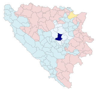
Doboj is a city in Republika Srpska, Bosnia and Herzegovina. It is situated on the banks of the Bosna river, in the northern region of Republika Srpska. As of 2013, it has a population of 71,441 inhabitants.

Zavidovići is a city and municipality located in Zenica-Doboj Canton of the Federation of Bosnia and Herzegovina, an entity of Bosnia and Herzegovina. It is situated in central Bosnia and Herzegovina, located between Doboj and Zenica on the confluence of rivers Bosna, Krivaja and Gostović. It sits in a valley surrounded by many mountains of which the largest is Klek. As of 2013, the municipality had a population of 35,988 inhabitants and the city itself 8,174.
Kakanj is a town and municipality located in Zenica-Doboj Canton of the Federation of Bosnia and Herzegovina, an entity of Bosnia and Herzegovina. As of 2013, the town has a population of 11,796 inhabitants, with 38,937 inhabitants in the municipality. It is situated in central Bosnia and Herzegovina, north of Visoko and southeast of Zenica. It was built along the slopes of wide hills on either side of the Zgošća river.

Šamac, formerly Bosanski Šamac is a town and municipality in Republika Srpska, Bosnia and Herzegovina. There are also small, uninhabited, parts located in the municipalities of Odžak and Domaljevac-Šamac, Federation of Bosnia and Herzegovina.
Derventa is a city in Republika Srpska, Bosnia and Herzegovina. It is situated in the Posavina region, northwest of the city of Doboj. As of 2013, the town has a total of 11,631 inhabitants, while the municipality has 27,404 inhabitants.

Gračanica is a city located in Tuzla Canton of the Federation of Bosnia and Herzegovina, an entity of Bosnia and Herzegovina. It is located in northeastern Bosnia and Herzegovina, east of Doboj and west of Tuzla. As of 2013, it has a population of 45,220 inhabitants.
Ilijaš is a town and municipality located in Sarajevo Canton of the Federation of Bosnia and Herzegovina, an entity of Bosnia and Herzegovina. It is located northwest of the inner city of Sarajevo, making it de facto a town and suburb of Sarajevo. The Ilijaš Municipality was established in May 1952 with the organization of people's committees. Those local people's committees founded the local municipalities, which led to the self-management of the municipalities, including the municipality of Ilijaš.

Žepče is a town and municipality located in Zenica-Doboj Canton of the Federation of Bosnia and Herzegovina, an entity of Bosnia and Herzegovina. It is situated in central Bosnia and Herzegovina, between Doboj and Zenica. As of 2013, it has a population of 30,219 inhabitants.

Prozor-Rama is a municipality located in Herzegovina-Neretva Canton of the Federation of Bosnia and Herzegovina, an entity of Bosnia and Herzegovina. Its seat is Prozor. Also, Ramsko lake is located in the municipality.
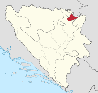
Brčko District, officially the Brčko District of Bosnia and Herzegovina, is a self-governing administrative unit in north-eastern Bosnia and Herzegovina.

Ključ is a town and municipality located in the Una-Sana Canton of the Federation of Bosnia and Herzegovina, an entity of Bosnia and Herzegovina. The name of the town and the municipality translates to "Key" in English.

Brod, formerly Bosanski Brod and Srpski Brod, is a town and municipality in Republika Srpska, Bosnia and Herzegovina. It is situated on the south bank of the river Sava, in the western part of the Posavina region. As of 2013, the town has a population of 7,637 inhabitants, while the municipality has a population of 16,619 inhabitants.

Konjic is a city located in the Herzegovina-Neretva Canton of the Federation of Bosnia and Herzegovina, one of two entities that make up Bosnia and Herzegovina. It is located in northern Herzegovina, around 60 kilometres (37 mi) southwest of Sarajevo, in a mountainous, heavily wooded area, and is 268 m (879 ft) above sea level. The municipality extends on both sides of the Neretva River. According to the 2013 census, the city of Konjic has a population of 10,732 inhabitants, whereas the municipality has 25,148.
Božinci Donji is a village in the municipality of Doboj, Republika Srpska, Bosnia and Herzegovina.
Osječani Donji is a village in the municipality of Doboj, Bosnia and Herzegovina.
Osječani Gornji is a village in the municipality of Doboj, Bosnia and Herzegovina.
Pridjel Donji is a village in the municipality of Doboj, Republika Srpska, Bosnia and Herzegovina.
Kamičak is a village in the municipality of Ključ, Bosnia and Herzegovina.
Donji Skugrić is a village in the municipalities of Modriča and Gradačac, Bosnia and Herzegovina. Donji means lower, so there is an upper one as well, Skugrić Gornji.
Donji Baraći is a settlement located in the Municipality of Mrkonjić Grad, of the Republika Srpska Entity in Bosnia and Herzegovina. It used to be a municipality in the Socialist Federal Republic of Yugoslavia until 1963, when it was abolished and incorporated into the Municipality of Mrkonjić Grad.
