
Olympia is the capital of the U.S. state of Washington and the county seat and largest city of Thurston County. It is located 60 miles (100 km) southwest of Seattle, the state's largest city, and is a cultural center of the southern Puget Sound region.

Thurston County is a county located in the U.S. state of Washington. As of the 2010 census, its population was 252,264. The county seat and largest city is Olympia, the state capital.
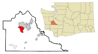
Tumwater is a city in Thurston County, Washington, United States. The population was 17,371 at the 2010 census. It is situated near where the Deschutes River enters Budd Inlet, the southernmost point of Puget Sound; it also borders the state capital of Olympia to the north. Tumwater is the oldest permanent Anglo-American settlement on Puget Sound.

The Kitsap Peninsula lies west of Seattle across Puget Sound, in Washington state in the Pacific Northwest. Hood Canal separates the peninsula from the Olympic Peninsula on its west side. The peninsula, a.k.a. "the Kitsap", encompasses all of Kitsap County except Bainbridge and Blake Islands, as well as the northeastern part of Mason County and the northwestern part of Pierce County. The highest point on the Kitsap Peninsula is Gold Mountain. The U.S. Navy's Puget Sound Naval Shipyard, and Naval Base Kitsap are on the peninsula. Its main city is Bremerton.

The Tumwater Falls are a series of cascades on the Deschutes River in Tumwater, Washington, United States. They are located near where the river empties into Budd Inlet, a southerly arm of Puget Sound in Olympia.

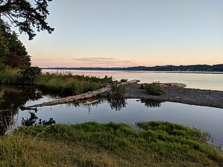
Budd Inlet is an inlet located at the southern end of Puget Sound in Thurston County, Washington. It is the southernmost arm of Puget Sound.

The Dofflemyer Point Lighthouse is a U.S. lighthouse in Boston Harbor, Washington, and was one of the first in the state of Washington to be automated. It sits at the northeastern entrance to Budd Inlet north of Olympia. It is the southernmost light in Puget Sound and is listed on the National Register of Historic Places.

The history of Olympia, Washington, includes long-term habitation by Native Americans, charting by a famous English explorer, settlement of the town in the 1840s, the controversial siting of a state college in the 1960s and the ongoing development of arts and culture from a variety of influences.

Totten Inlet lies in the southern end of Puget Sound in the U.S. state of Washington. The inlet extends 9 miles (14 km) southwest from the western end of Squaxin Passage, and much of the county line between Mason and Thurston counties runs down the center of it. A spit extends west for about 300 feet (91 m) from Steamboat Island. The inlet shoals gradually to near Burns Point, 100 feet high, on the south shore, where it bares at low tide.

Boston Harbor is an unincorporated community in Thurston County, Washington. Seattle real estate developer C. D. Hillman platted the site in 1907 and promoted sale of the lots by offering cash prizes to buyers. The community is home to the Dofflemyer Point Light, built in 1934 and listed on the National Register of Historic Places in 1995.
Eld Inlet is an inlet located at the southern end of Puget Sound in Thurston County, Washington. It is the second southernmost arm of Puget Sound after neighboring Budd Inlet.

Percival Landing Park is a public park located in Olympia, Washington.

Woodard Bay Natural Resources Conservation Area is a natural reserve in Olympia, Washington protected under the Washington Natural Areas Program. Once an important processing facility for the logging industry, it has been designated as the Weyerhaeuser South Bay Log Dump Rural Historic Landscape. Today the area is a renowned sanctuary for a variety of birds, harbor seals, river otters, bald eagles, and a colony of bats, as well as serving as an important great blue heron rookery. A recent conservation program in the area between the State of Washington and the Nature Conservancy is the first of its kind in the country.
Henderson Inlet is a small, southern inlet of Puget Sound, Washington state, situated between Budd Inlet to the west and Nisqually Reach to the east. It is located in Thurston County and the nearest city is Olympia, the state capital. Henderson Inlet was named in 1841 by Charles Wilkes, commander of the United States Exploring Expedition, after James Henderson, who served as quartermaster. A variant name is "South Bay".
Moxlie Creek is a stream in Thurston County in the U.S. state of Washington. It is an Olympian creek originating from artesian springs in Watershed Park. It flows north into the East Bay of Budd Inlet. The creek is piped underground between East Bay and the headwaters, more than one third of its 1.8 mile length. For over 50 years the park groundwater was used to supply the city's drinking water, and waterworks remnants can be seen in the area.
Indian Creek is a stream in Thurston County in the U.S. state of Washington. It is a 3-mile Olympian creek. Its source is a wetland along the northern end of South Bay Road. It enters Budd Inlet at East Bay, having first joined with Moxlie Creek. It can most easily be accessed between Boulevard Road and Frederick Road along the Karen Fraser Woodland Trail. American Indian settlements near the creek's course may account for the name.
Mud Bay is the southernmost reach of Puget Sound, at Eld Inlet just outside the city limits of Olympia, Washington. The name Eld Inlet was officially bestowed after a member of the U.S. Navy's Wilkes Expedition, but "Mud Bay" is a local, informal adoption.
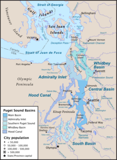
South Puget Sound is the southern reaches of Puget Sound in Southwest Washington, in the United States' Pacific Northwest. It is one of five major basins encompassing the entire Sound, and the shallowest basin, with a mean depth of 37 meters (121 ft). Exact definitions of the region vary: the state's Department of Fish and Wildlife counts all of Puget Sound south of the Tacoma Narrows for fishing regulatory purposes. The same agency counts Mason, Jefferson, Kitsap, Pierce and Thurston Counties for wildlife management. The state's Department of Ecology defines a similar area south of Colvos Passage.
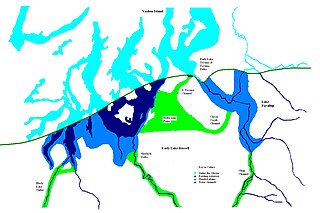
During the Vashon Glaciation a series of lakes formed along the southern margin of the Cordilleran Ice Cap. In the Puget Sound depression, a series of lakes developed, of which Lake Russell was the largest and the longest lasting. Early Lake Russell’s surface was at 160 ft (49 m) above sea level, draining across the divide at Shelton, Washington into early Glacial Lake Russell. When the ice margin receded northward, the lake expanded. When it reached the Clifton channel outlet, the water levels dropped to 120 ft (37 m) above sea level. The new longer and lower level lake is referred to as Lake Hood. The glacier continued to retreat until the northern outlet of the Hood Canal was reached as the water level equalized with Glacial Lake Russell becoming part of that body of water.
Burfoot Park is a public park located in Thurston County, Washington. Burfoot Park covers 50 acres of property with 1,100 feet of saltwater beach frontage on Budd Inlet of the Puget Sound.

