Hampstead is an area in London, England, which lies four miles northwest of Charing Cross, and extends from the A5 road to Hampstead Heath, a large, hilly expanse of parkland. The area forms the northwest part of the London Borough of Camden, a borough in Inner London which for the purposes of the London Plan is designated as part of Central London.

Hampstead was a civil parish and metropolitan borough in London, England. It was an ancient parish in the county of Middlesex, governed by an administrative vestry. The parish was included in the area of responsibility of the Metropolitan Board of Works in 1855 and became part of the County of London in 1889. The parish of Hampstead became a metropolitan borough in 1900, following the London Government Act 1899, with the parish vestry replaced by a borough council. In 1965 the borough was abolished and its former area became part of the London Borough of Camden in Greater London.

Primrose Hill is a Grade II listed public park located north of Regent's Park in London, England, first opened to the public in 1842. It was named after the 64 metres (210 ft) natural hill in the centre of the park, one of the highest natural points in the London Borough of Camden. The hill summit has a clear view of central London, as well as Hampstead and Belsize Park to the north and is adorned by an engraved quotation from William Blake. Based on the popularity of the park, the surrounding district and electoral ward were named Primrose Hill. The Primrose Hill district is in the London Borough of Camden, England.

Swiss Cottage is an area of Hampstead in the London Borough of Camden, England. It is centred on the junction of Avenue Road and Finchley Road and includes Swiss Cottage tube station. Swiss Cottage lies 3.25 miles (5.23 km) north-northwest of Charing Cross. The area was named after a public house in the centre of it, known as "Ye Olde Swiss Cottage".

Belsize Park is an affluent residential area of Hampstead in the London Borough of Camden, England.
The London Borough of Camden is in percentage terms the second-greenest of the Inner London boroughs. It contains most of the swathe of land Hampstead Heath and many smaller green spaces. The Central London part of the borough, south of Euston Road, is characterised by its elegant garden squares with large instances: Tavistock Square and Bedford Square. In this part runs the Regent's Canal around the top edge of Regent's Park, a little of which is in Camden, including all of associated Primrose Hill. Highgate Cemetery is in Camden but Highgate Wood is in the neighbouring borough of Haringey.
South Hampstead is an affluent part of the London Borough of Camden in inner north London. It is commonly defined as the area between West End Lane in the west, the Chiltern Main Line (south), Broadhurst Gardens north and north-west followed by a non-road line demarcating the south slopes of Hampstead village, west of Belsize Park, and north and west of the usually narrowly defined Swiss Cottage neighbourhood. It takes in some of Fitzjohns Avenue leading up to "the village", but the exact amount is an arbitrary measure. The streets were laid out in the Victorian era. The area was not served by any railways until Loudoun Road station opened in 1879 on the street of that name.

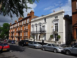
Belsize Park Gardens is a street in the Belsize Park area of Hampstead in London. Located in the London Borough of Camden, it is residential street featuring white stucco Victorian era buildings. It runs roughly southeastwards from Belsize Avenue in Belsize Village before terminating at a junction with Eton Avenue, England's Lane and Primrose Hill Road. The Grade II listed pub The Washington, dating from around 1865, is located at its eastern end.

Primrose Hill is a district in the London Borough of Camden, England.

Gloucester Avenue is a street in the Primrose Hill area of London, England. Located in the London Borough of Camden, it is a residential road featuring many nineteenth century properties including several pubs as well as the neo-Georgian Cecil Sharp House. For much of its route it runs adjacent to the West Coast Main Line out of Euston Station.

Regent's Park Road is a street in the Primrose Hill area of London, England. Located in the London Borough of Camden, it runs in a curving crescent shape. For some of its route it follows alongside the eastern edge of Primrose Hill park and also includes the commercial centre of the area. Despite its name the street does not run as far as Regent's Park although the adjacent Prince Albert Road does.

Eton Avenue is a street in the Belsize Park area of Hampstead in North London. Located in the London Borough of Camden, it runs eastward from Swiss Cottage tube station to a junction with England's Lane, Primrose Hill Road and Belsize Park Gardens by The Washington pub. Fellows Road and Adelaide Road run parallel to the south of Eton Avenue.

Belsize Lane is a street in the Belsize Park area of Hampstead in London. Located in the London Borough of Camden, it runs east to west from Haverstock Hill to Fitzjohns Avenue. While residential for much of the route, it also features a group of commercial properties that form the centre of Belsize Village. The Tavistock Clinic is located at its western end.

Belsize Avenue is a street in the Belsize Park area of Hampstead. Located in the London Borough of Camden, it runs from Haverstock Hill westwards to a junction with Belsize Terrace and Belsize Park Gardens. It is the former carriageway approach to Belsize House, a country estate that occupied the area until it was demolished in 1853 to allow residential development. A number of houses in the street were built by William Willett around 1873.

Loudoun Road is a street in the St John's Wood area of London. Most of its route is in the City of Westminster, but it crosses into the London Borough of Camden at its northern end in South Hampstead. It runs roughly parallel to Finchley Road to its east while Abbey Road, London is to the west. It runs north from Grove End Road, not far from St John's Wood tube station, and crosses or is joined by a number of streets including Marlborough Place, Carlton Hill and Boundary Road. It finishes at a roundabout junction with several streets including Belsize Road and Fairhazel Gardens. South Hampstead railway station is at the northern end of the street.

Adelaide Road is a street in London running east to west between Chalk Farm and Swiss Cottage. Located in the London Borough of Camden it is part of the longer B509 route which continues as Belsize Road through South Hampstead. The Belsize Park area of Hampstead is to its north while Primrose Hill is to the south. It runs parallel to Fellows Road and Eton Avenue. Along its route it meets or is crossed by several streets including Primrose Hill Road and Avenue Road. At its eastern end is Chalk Farm tube station at the junction with Haverstock Hill, which opened in 1907. It takes its name from Queen Adelaide, wife of William IV.

Priory Road is a street in Kilburn. Located in the London Borough of Camden it runs northwards from Belsize Road through South Hampstead crossing several streets including Abbey Road before finishing at a junction with Broadhurst Gardens, not far from West Hampstead tube station. It takes its name from the old Kilburn Priory located in the area until the dissolution of the monasteries under Henry VIII.

Broadhurst Gardens is a street in the London Borough of Camden running eastwards from West End Lane in West Hampstead and ending near to the Finchley Road. It forms the northern border of South Hampstead, and runs parallel to the Midland Main Line. It meets or is crossed by Priory Road, Fairhazel Gardens and Canfield Gardens.

Belsize Road is a street in the London Borough of Camden. It runs west to east from Kilburn High Road to close to Finchley Road in the Swiss Cottage area of Hampstead. It is part of the B509 route which continues eastwards as Adelaide Road to Chalk Farm tube station. Despite its name it is located to the west of Belsize Park in the South Hampstead area. Much of its route runs parallel to the Midland Main Line and Kilburn High Road station is at its eastern end. It meets a number of streets including Loudoun Road, Abbey Road and Priory Road.

Fitzjohns Avenue is a street in Hampstead, England. Located in the London Borough of Camden it runs northwards from College Crescent to join and become Heath Street in Hampstead Village. Running steeply uphill for much of its route Fitzjohns Avenue is joined or crossed by various other streets including Belsize Park, Belsize Lane, Maresfield Gardens, Netherhall Gardens, Akenfield Road and Lyndhurst Road. It is classified as part of the B511 road. It is also sometimes written as Fitzjohn's Avenue.


