
Prince Rupert is a port city in the province of British Columbia, Canada. Its location is on Kaien Island near the Alaskan panhandle. It is the land, air, and water transportation hub of British Columbia's North Coast, and has a population of 12,220 people as of 2016.

The Grand Trunk Pacific Railway was a historic Canadian transcontinental railway running from Fort William, Ontario to Prince Rupert, British Columbia, a Pacific coast port. East of Winnipeg the line continued as the National Transcontinental Railway (NTR), running across northern Ontario and Quebec, crossing the St. Lawrence River at Quebec City and ending at Moncton, New Brunswick. The Grand Trunk Railway (GTR) managed and operated the entire line.

Nathan Cullen is a Canadian politician. A member of the New Democratic Party (NDP), he is the Member of the Legislative Assembly (MLA) for Stikine in British Columbia. He has served in the Executive Council of British Columbia since 2020, currently as Minister of Water, Land and Resource Stewardship and Minister Responsible for Fisheries.

Kaien Island is a Canadian island on the coast of British Columbia, just north of the mouth of the Skeena River and to the south of the Alaska Panhandle. The island has an area of about 45 square kilometres, is roughly oval, and about 11 kilometres (6.8 mi) long along its long axis. The island consists of a central mountain ridge, surrounded by coastal lowlands, the dominant central peak is Mount Hays reaching 708 metres (2,323 ft), with a secondary peak, Mount Olfield reaching 555 metres (1,821 ft) to the northeast.

Cariboo—Prince George is a federal electoral district in the province of British Columbia, Canada, that has been represented in the House of Commons of Canada since 2004.
Skeena—Bulkley Valley is a federal electoral district in British Columbia, Canada, that has been represented in the House of Commons of Canada since 2004.
Cariboo was a federal electoral district in British Columbia, Canada, that was represented in the House of Commons of Canada from 1871 to 1892.
Skeena was a federal electoral district in British Columbia, Canada, that was represented in the House of Commons of Canada from 1917 to 2004.
Cariboo—Chilcotin was a federal electoral district in British Columbia, Canada, that was represented in the House of Commons from 1979 to 2003.

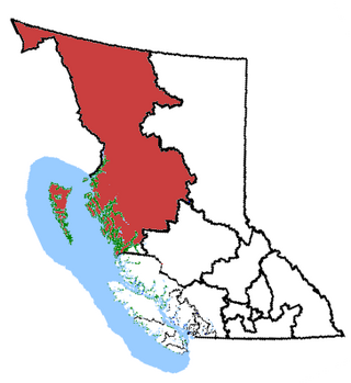
North Coast is a provincial electoral district for the Legislative Assembly of British Columbia, Canada. It was created by 1990 legislation which came into effect for the 1991 election, largely out of the previous riding of Prince Rupert.

Skeena is a provincial electoral district for the Legislative Assembly of British Columbia, Canada. It first appeared in the provincial election of 1924. It should not be confused with the former federal electoral district of Skeena, which encompassed a larger area.

British Columbia is the westernmost province of Canada, bordered by the Pacific Ocean. With an area of 944,735 km2 (364,764 sq mi) it is Canada's third-largest province. The province is almost four times the size of the United Kingdom and larger than every United States state except Alaska. It is bounded on the northwest by the U.S. state of Alaska, directly north by Yukon and the Northwest Territories, on the east by Alberta, and on the south by the U.S. states of Washington, Idaho, and Montana. Formerly part of the British Empire, the southern border of British Columbia was established by the 1846 Oregon Treaty. The province is dominated by mountain ranges, among them the Canadian Rockies but dominantly the Coast Mountains, Cassiar Mountains, and the Columbia Mountains. Most of the population is concentrated on the Pacific coast, notably in the area of Vancouver, located on the southwestern tip of the mainland, which is known as the Lower Mainland. It is the most mountainous province of Canada.
Atlin was a provincial electoral district in the Canadian province of British Columbia. It made its first appearance on the hustings in the 10th provincial general election in 1903 and last appeared in the 34th provincial general election in 1986, after which it was merged with the Skeena riding and was succeeded by Bulkley Valley-Stikine.
The North Coast Regional District is a quasi-municipal administrative area in British Columbia. It is located on British Columbia's west coast and includes Haida Gwaii, the largest of which are Graham Island and Moresby Island. Its administrative offices are in the City of Prince Rupert.
An electoral redistribution was undertaken in 2008 in British Columbia in a process that began in late 2005 and was completed with the passage of the Electoral Districts Act, 2008 on April 10, 2008. The redistribution modified most electoral boundaries in the province and increased the number of MLAs from 79 to 85. The electoral boundaries created by the redistribution were first used in the 2009 provincial election.

Jennifer Rice is a Canadian politician, who was elected to the Legislative Assembly of British Columbia to represent the electoral district of North Coast. She is a member of the BC New Democratic Party. Rice was first elected as a member of legislative assembly (MLA) in the 2013 provincial election and was re-elected in the 2017 election. In the 40th Parliament of British Columbia she acted as the official opposition's critic for northern and rural economic development and deputy critic for children and family development and introduced one private member bill, the Drinking Water Protection Amendment Act regarding regularizing testing of drinking water in schools.
An electoral redistribution in British Columbia was undertaken by the BC Electoral Boundaries Commission beginning in 2014 and was formalized by the passage of Bill 42, the 2015 Electoral Districts Act, during the 40th British Columbia Parliament. The act came into effect on November 17, 2015. The redistribution added two seats to the previous total, increasing the number of MLAs in the province from 85 to 87. The electoral boundaries came into effect for the 2017 election. The next redistribution is required to occur following the 2020 British Columbia general election.