Princes' Island

Last updated
Princes' Island, southwards Prinzeninsel.jpg
Princes' Island, southwards
Beach of Princes' Island with view in the direction of Ascheberg Strand der Prinzeninsel.jpg
Beach of Princes' Island with view in the direction of Ascheberg

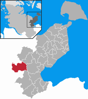
The Princes' Island [1] (German : Prinzeninsel) is a peninsula in the Großer Plöner See southwest of the town of Plön in the north German state of Schleswig-Holstein.

German language West Germanic language

German is a West Germanic language that is mainly spoken in Central Europe. It is the most widely spoken and official or co-official language in Germany, Austria, Switzerland, South Tyrol (Italy), the German-speaking Community of Belgium, and Liechtenstein. It is also one of the three official languages of Luxembourg and a co-official language in the Opole Voivodeship in Poland. The languages which are most similar to German are the other members of the West Germanic language branch: Afrikaans, Dutch, English, the Frisian languages, Low German/Low Saxon, Luxembourgish, and Yiddish. There are also strong similarities in vocabulary with Danish, Norwegian and Swedish, although those belong to the North Germanic group. German is the second most widely spoken Germanic language, after English.

Großer Plöner See The largest lake in Schleswig-Holstein, Germany

The Großer Plöner See or Lake Plön is the largest lake (30 km²) in Schleswig-Holstein, Germany. It is located near the town of Plön. Its main tributary, as well as its main outflow, is the River Schwentine.

Plön Place in Schleswig-Holstein, Germany

Plön is the district seat of the Plön district in Schleswig-Holstein, Germany, and has about 8,700 inhabitants. It lies right on the shores of Schleswig-Holstein's biggest lake, the Great Plön Lake, as well as on several smaller lakes, touching the town on virtually all sides. The town's landmark is Plön Castle, a chateau built in the 17th century on a hill overlooking the town.

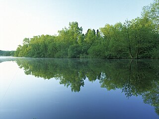
Princes' Island was turned into a peninsula in the 19th century by the artificial lowering of the water level. It is about 2 km long and only about 30 m wide in places. At the southern end is the Niedersächsisches Bauernhaus ("Lower Saxon farmhouse") dating to the 17th century, which is now operated as a restaurant and breeds geese and moorland sheep of the Heidschnucke variety. Princes' Island is mainly forested, but some areas of the shoreline are also swampy. It is closed to motor traffic.

Peninsula A piece of land that is bordered by water on three sides but connected to mainland

A peninsula is a landform surrounded by water on the majority of its border while being connected to a mainland from which it extends. The surrounding water is usually understood to be continuous, though not necessarily named as a single body of water. Peninsulas are not always named as such; one can also be a headland, cape, island promontory, bill, point, or spit. A point is generally considered a tapering piece of land projecting into a body of water that is less prominent than a cape. A river which courses through a very tight meander is also sometimes said to form a "peninsula" within the loop of water. In English, the plural versions of peninsula are peninsulas and, less commonly, peninsulae.

Low German house type of timber-framed farmhouse found in Northern Germany and the Netherlands, which combines living quarters, byre and barn under one roof

The Low German house or Fachhallenhaus is a type of timber-framed farmhouse found in Northern Germany and the Netherlands, which combines living quarters, byre and barn under one roof. It is built as a large hall with bays on the sides for livestock and storage and with the living accommodation at one end. The Low German house appeared during the 13th to 15th centuries and was referred to as the Low Saxon house (Niedersachsenhaus) in early research works. Until its decline in the 19th century, this rural, agricultural farmhouse style was widely distributed through the North German Plain, all the way from the Lower Rhine to Mecklenburg. Even today, the Fachhallenhaus still characterises the appearance of many north German villages.

Heidschnucke sheep breed

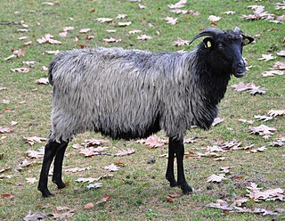
The Heidschnucke is a group of three types of moorland sheep from northern Germany. Like a number of other types from Scandinavia and Great Britain, they are Northern European short-tailed sheep. The three breeds of Heidschnucke are:

The sons of the last German Emperor William II learned agricultural skills on the old farm which their father had purchased, while they lived in the Princes' House on the bank of the lake. The southern tip of the Prinzeninsel was a favourite spot of the last German Empress, Augusta Victoria of Schleswig-Holstein. The current owner of the island is Georg Friedrich, Prince of Prussia.

Princes House

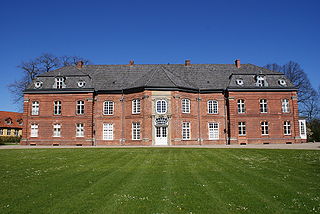
The Princes' House in Plön in the North German state of Schleswig-Holstein is a former royal summer residence in the grounds of the park at Plön Castle. It is the only surviving maison de plaisance in Schleswig-Holstein.

Augusta Victoria of Schleswig-Holstein German empress

Augusta Victoria of Schleswig-Holstein was the last German empress and queen of Prussia by marriage to Wilhelm II, German Emperor.

Georg Friedrich, Prince of Prussia Current German pretender

Georg Friedrich Ferdinand, Prince of Prussia is the current head of the Prussian branch of the House of Hohenzollern, the former ruling dynasty of the German Empire and of the Kingdom of Prussia. He is the great-great-grandson and historic heir of Wilhelm II, the last German Emperor and King of Prussia, who was deposed and went into exile upon Germany's defeat in World War I in 1918.

The boats of the Großer-Plöner-See-Rundfahrt, that make round trips of the lake, land near the Niedersächsisches Bauernhaus. At the farmhouse is an inscription: melior nihil nihil homini libero dignius agricultura 1901: "Nothing is better, nothing more worthy of free people, than farming."

The peninsula also has an outdoor swimming pool, which goes under the name of Prinzenbad ("Princes' pool"), because the Hohenzollern sons learnt to swim there. It has a fine sandy beach on the west side where the lake bed shelves very gently so that, 30 metres offshore, the depth is just 1.20 metres. Whilst from 1947-1963 there was a campsite and restaurant here on a very small scale, bathers are now largely on their own. In the modern buildings that have replaced the old ones, there is, inter alia, a lifeguard station of the DLRG in Plon.

House of Hohenzollern dynasty of former princes, electors, kings, and emperors of Hohenzollern, Brandenburg, Prussia, the German Empire, and Romania

The House of Hohenzollern[ˈhoːəntsɔlɐn] is a German dynasty of former princes, electors, kings and emperors of Hohenzollern, Brandenburg, Prussia, the German Empire, and Romania. The family arose in the area around the town of Hechingen in Swabia during the 11th century and took their name from Hohenzollern Castle. The first ancestors of the Hohenzollerns were mentioned in 1061.

Related Research Articles

Plön is a district in Schleswig-Holstein, Germany. It is bounded by the districts of Ostholstein and Segeberg, the city of Neumünster, the district of Rendsburg-Eckernförde, the city of Kiel and the Baltic Sea.

Ostholstein is a district in Schleswig-Holstein, Germany. It is bounded by the districts of Stormarn, Segeberg and Plön, the Baltic Sea and the city of Lübeck.

Holstein Region of Schleswig-Holstein, Germany

Holstein is the region between the rivers Elbe and Eider. It is the southern half of Schleswig-Holstein, the northernmost state of Germany.

Bosau Place in Schleswig-Holstein, Germany

Bosau is a municipality on the Great Plön Lake the district of Ostholstein, in Schleswig-Holstein, Germany. It is situated approximately 13 km west of Eutin, and 30 km southeast of the state capital of Kiel.

Großer Plöner See (Amt) Place in Schleswig-Holstein, Germany

Großer Plöner See is an Amt in the districts of Plön and Ostholstein in Schleswig-Holstein, Germany. It is situated around Plön, which is the seat of the Amt, but not part of it. The Amt is named after the lake Großer Plöner See.

The Max Planck Institute for Evolutionary Biology is a German institute for evolutionary biology. It is located in Plön, Schleswig-Holstein, Germany.

Schwentine river in Schleswig-Holstein, Germany

The Schwentine is a river in the North German state of Schleswig-Holstein. It is approximately 62 kilometres (39 mi) long and rises on the hill of Bungsberg, the highest point in the state, near the village of Kasseedorf in Ostholstein. It then runs from its source to Kiel where it flows into the Kiel Fjord, a bay of the Baltic Sea. It passes through several lakes, including the Großer Plöner See, the largest lake in Schleswig-Holstein, as well as the towns Eutin, Malente, Plön, Preetz and Kiel.

Holstein Switzerland rolling country

Holstein Switzerland is a hilly area with a patchwork of lakes and forest in Schleswig Holstein, Germany, reminiscent of Swiss landscape. Its highest point is the Bungsberg. It is a designated nature park as well as an important tourist destination in Northern Germany situated between the cities of Kiel and Lübeck.

Selenter See lake in Plön District, Schleswig-Holstein, Germany

The Selenter See is the second-largest lake in the North German state of Schleswig-Holstein, after the Großer Plöner See. It lies at an elevation of 37 m above sea level (NN) and has an area of 22.4 km².

The Höftsee is a lake in the Holstein Switzerland in North Germany. It lies on the River Schwentine east of the town of Plön between the Behler See and the Großer Plöner See. It has an area of about 18 hectares, is up to 16 metres deep and lies about 22 m above sea level (NN).

Dieksee lake

The Dieksee is a lake in the Holstein Switzerland region of North Germany.

The Kleine Plöner See is a lake in Holstein Switzerland in North Germany.

Großer Eutiner See lake in Eutin, Schleswig-Holstein, Germany

The Großer Eutiner See is a lake in Holstein Switzerland, Schleswig-Holstein, Germany. It lies northeast of the town of Eutin.

Wagria peninsula

Wagria is the northeastern part of Holstein in the German state of Schleswig-Holstein, corresponding roughly to the districts of Plön and Ostholstein. The word "Wagria" is derived from Germanic settlement of Waringer and just a bit later the West Slavic Lechites tribe of Wagri or Wagier, which meant "those who live by the bays". Wagria was occupied from Viking of Haithabu. It seems that the Wagrier are identical with the East Germanic tribe of Waringer or Warnen. This country is a historical landscape of Viking myths.

Plön Castle German castle

Plön Castle in Plön is one of the largest castles in the north German state of Schleswig-Holstein and the only one located on a hill. The former Residenz of the Dukes of Schleswig-Holstein-Plön was built in the 17th century during the Thirty Years War and has had a colourful history in which it has, for example, been a school for military cadets and also a boarding school.

Parnass Tower tower

The Parnass Tower is an observation tower in the town of Plön in the North German state of Schleswig-Holstein. It sits on the summit of the low hill of Parnaß.

Tensfelder Au river in Germany

Tensfelder Au is a river of Schleswig-Holstein, Germany. It springs north of the village of Blunk and then flows in a northeasterly direction through the town of Tensfeld and Hornsmühlen into the lake Großer Plöner See. After the Schwentine, the Tensfelder Au is the second largest river flowing into the Großer Plöner See.

King Alfred School, Plön

King Alfred School, Plön, was a boarding school for children whose parents were British military or civil service personnel working in Germany; between 1948 and 1959, it educated approximately 4000 pupils aged between 11 and 18 years old.

References

  1. Round Tour through the Historic Monument Ploen at www.touristinfo-ploen.de. Accessed on 31 Aug 10.

Coordinates: 54°8′21.066″N10°24′33.59″E / 54.13918500°N 10.4093306°E / 54.13918500; 10.4093306

Geographic coordinate system Coordinate system

A geographic coordinate system is a coordinate system that enables every location on Earth to be specified by a set of numbers, letters or symbols. The coordinates are often chosen such that one of the numbers represents a vertical position and two or three of the numbers represent a horizontal position; alternatively, a geographic position may be expressed in a combined three-dimensional Cartesian vector. A common choice of coordinates is latitude, longitude and elevation. To specify a location on a plane requires a map projection.