Princes End

Last updated

The Tilted Barrel public house The Tilted Barrel Public House, High St, Princes End - geograph.org.uk - 299980.jpg
The Tilted Barrel public house

Princes End is an area of Tipton, West Midlands, England, near the border with Coseley (of which approximately half of the area was part of until 1966), which was heavily developed during the 19th century with the construction of factories. The population of the Sandwell ward taken at the 2011 census was 12,981. [1] Several hundred terraced houses were built around the same time to accommodate the factory workers. Many council houses were built in the area between 1920 and 1980, as well as many private houses.

Contents

Neighbourhood

The centre of Princes End is situated on the A4037 Dudley - Wednesbury main road. It includes shops, flats and houses.

The established residential area of the Tibbington Estate and Ocker Hill area including the Glebefields Estate and Moat Farm Estates "Lost City" are part of Princes End Ward for Voting purposes only but not actually in Princes End itself.

Wednesbury Oak, originally a small settlement on the main road leading towards Wednesbury and Walsall, was expanded in the 1950s and 1960s with the development of a large private housing estate, which was originally in the Urban District of Coseley.

Railway

Princes End had two railway stations, but neither are in existence now. One was Princes End and Coseley railway station, which was situated on the line between Dudley and Bilston. It closed in 1962 under the Beeching Axe and by the end of the 1960s the line was in total disuse.

The other station, Princes End railway station, closed in 1916 under a wartime economy measure, although the line - which ran to Wednesbury - remained open to goods trains until 1981, with the final stub leading up to Ocker Hill Power Station remaining open until 1991.

The former section of line between Princes End and Ocker Hill also marks the divide between Princes End and The Tibbington Estate, The Glebefields Estate and Moat Farm Estates "LOST CITY" That come under Ocker Hill and was converted into a public walkway at the end of the 1980s.

Industry

Bloomfield Road has been home to the Angle Ring factory since 1951. The factory's buildings and land have been gradually expanded over the years, taking over a section of the Dudley to Bilston railway which closed in 1968. Opposite the Angle Ring factory stood the British Rolling Mills, which opened in the 19th century and remained in use until 2005 as part of Brymill. The buildings, including the offices and laboratories built in 1959, were demolished in the autumn of 2006 and gave way to housing. However, one of the more modern Brymill factory and office units still stands and although currently disused, has been retained for eventual sale due to its age.

Bloomfield Infants School

Bloomfield Infants School was opened on Bloomfield Road in 1873, later becoming an annexe of Princes End Infants School. However, it closed in July 1967 after 94 years in use as a school and was briefly annexed into Princes End Infants School, but this was short-lived and the building was closed in the early 1970s and demolished a short time afterwards. The site of the school is now a scrapyard, which expanded in 2000 when the neighbouring Kings Arms public house (closed in the mid 1990s) was demolished. [2]

Unemployment

In the 2001 census, it was revealed that 10.9% of economically active people in Princes End were unemployed - more than double the national average at the time. The figure rose substantially after 2007 due to the Late 2000s recession, but was falling by 2015 as the economic recovery accelerated. [3] [ failed verification ]

Boundary changes

Although the bulk of Princes End was situated within the Tipton borders, until 1966 a significant percentage of the area formed part of Coseley urban district council until 1966, when the borders were rationalised and the whole area became part of West Bromwich borough (which most of Tipton had become part of) and from 1974 Sandwell, which was formed by a merger of West Bromwich and Warley. The historic boundary of Coseley and Tipton had seen at least one building in Princes End being divided between the two towns.

Related Research Articles

<span class="mw-page-title-main">West Bromwich</span> Town in West Midlands, England

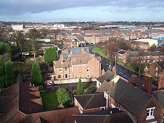
West Bromwich, commonly known as West Brom, is a market town in the borough of Sandwell, West Midlands, England. Historically part of Staffordshire, it is 7 miles northwest of Birmingham. West Bromwich is part of the area known as the Black Country, in terms of geography, culture and dialect. West Bromwich had a population of 103,112 in the 2021 Census.

<span class="mw-page-title-main">Tipton</span> Town in the West Midlands, England

Tipton is an industrial town in the Metropolitan Borough of Sandwell in the West Midlands County in England. It had a population of 38,777 at the 2011 UK Census. It is located northwest of Birmingham and southeast of Wolverhampton. It is also contiguous with nearby towns of Darlaston, Dudley, Wednesbury and Bilston.
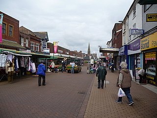
<span class="mw-page-title-main">Wednesbury</span> Town in West Midlands, England

Wednesbury is a market town in Sandwell in the West Midlands County, England - historically in Staffordshire. It is located near the source of the River Tame, and is part of the Black Country. Wednesbury is situated 5 miles (8km) south-east of Wolverhampton, 2.7 miles (4.4km) south-west of Walsall, and 7.3 miles (11.8km) north-west of Birmingham. At the 2011 Census the town had a population of 37,817.

<span class="mw-page-title-main">Sandwell</span> Metropolitan borough in England

Sandwell is a metropolitan borough of the West Midlands county in England. The borough is named after the Sandwell Priory, and spans a densely populated part of the West Midlands conurbation. Sandwell Metropolitan Borough Council defines the borough as the six amalgamated towns of Oldbury, Rowley Regis, Smethwick, Tipton, Wednesbury and West Bromwich. Rowley Regis includes the towns of Blackheath and Cradley Heath.

<span class="mw-page-title-main">Bilston</span> Market town in the West Midlands, England

Bilston is a market town in the City of Wolverhampton in the West Midlands, England. It is close to the borders of Sandwell and Walsall. The nearest towns are Darlaston, Wednesbury, and Willenhall. Historically in Staffordshire, three wards of Wolverhampton City Council now cover the town: Bilston East and Bilston North, which almost entirely comprise parts of the historic Borough of Bilston, and Ettingshall, which comprises a part of Bilston and parts of Wolverhampton.

The West Midlands region straddles the historic borders between the counties of Warwickshire, Staffordshire in the north, and Worcestershire in the south.

<span class="mw-page-title-main">Coseley</span> Human settlement in England

Coseley is a village in the Dudley Metropolitan Borough, in the West Midlands County, England. It is situated three miles north of Dudley itself, on the border with Wolverhampton and Sandwell. It falls within the Tipton and Wednesbury parliamentary constituency.

<span class="mw-page-title-main">Bradley, West Midlands</span> Human settlement in England

Bradley is a suburban village in the City of Wolverhampton, West Midlands County, England. It is located in the Bilston East ward.

<span class="mw-page-title-main">West Bromwich West (UK Parliament constituency)</span> Parliamentary constituency in the United Kingdom, 1974 onwards

West Bromwich West was a constituency in the West Midlands in the House of Commons of the UK Parliament. It was represented from 1974 until 2019 by members of the Labour Party, and by the Conservatives from 2019 until 2024.

<span class="mw-page-title-main">Great Bridge, West Midlands</span> District of Tipton, West Midlands, England

Great Bridge is a historic village and district of Tipton in the Metropolitan Borough of Sandwell in the metropolitan county of the West Midlands, England. It is situated near the towns of Dudley, West Bromwich and Wednesbury.

<span class="mw-page-title-main">Tipton Green</span> Area of Tipton in West Midlands, England

Tipton Green is the central area of Tipton, a town in the West Midlands of England. It was heavily developed for heavy industry and housing during the 19th century, as Tipton was one of the most significant towns during the Industrial Revolution. Tipton Green is one of three electoral wards covering Tipton for Sandwell Metropolitan Borough Council. The population of this Sandwell ward taken at the 2011 census was 12,834. It is represented by three Labour councillors.

<span class="mw-page-title-main">Ocker Hill</span>

Ocker Hill is a residential area straddling the border of Tipton and Wednesbury in the West Midlands of England.

Hateley Heath is a residential area of West Bromwich, West Midlands.The population of the Sandwell ward taken at the 2011 census was 14,227.

<span class="mw-page-title-main">Birmingham Snow Hill to Wolverhampton Low Level Line</span>

The Birmingham Snow Hill to Wolverhampton Low Level Line was part of the Great Western Railway's London Paddington to Birkenhead Woodside route. As the name suggests, it ran between Birmingham Snow Hill and Wolverhampton Low Level in England. The line was dual-gauged, both 7 ft 14 in and 4 ft 8+12 instandard gauge.

The Princes End branch line was a railway located in the West Midlands of England, which opened in September 1863 and survived as a through route for nearly 120 years.

The BCN Main Line, or Birmingham Canal Navigations Main Line is the evolving route of the Birmingham Canal between Birmingham and Wolverhampton in England.

<span class="mw-page-title-main">Wednesbury Oak Loop</span>

The Wednesbury Oak Loop, sometimes known as the Bradley Arm, is a canal in the West Midlands, England. It is part of the Birmingham Canal Navigations (BCN), and was originally part of James Brindley's main line, but became a loop when Thomas Telford's improvements of the 1830s bypassed it by the construction of the Coseley Tunnel. The south-eastern end of the loop was closed and in parts built over, following the designation of the entire loop as "abandoned" in 1954, including the section which was filled in at the beginning of the 1960s to make way for the Glebefields Estate in Tipton.

References

  1. "Sandwell Ward population 2011" . Retrieved 18 December 2015.
  2. "Black Country History". blackcountryhistory.org. Archived from the original on 12 August 2011.
  3. "Archived copy". Archived from the original on 25 July 2011. Retrieved 21 July 2010.{{cite web}}: CS1 maint: archived copy as title (link)

See also

52°32′33″N2°03′49″W / 52.5426°N 2.0635°W / 52.5426; -2.0635