
The Toronto waterfront is the lakeshore of Lake Ontario in the city of Toronto, Ontario, Canada. It spans 46 kilometres between the mouth of Etobicoke Creek in the west and the Rouge River in the east.

The Port of Liverpool is the enclosed 7.5-mile (12.1 km) dock system that runs from Brunswick Dock in Liverpool to Seaforth Dock, Seaforth, on the east side of the River Mersey and the Birkenhead Docks between Birkenhead and Wallasey on the west side of the river.

Toronto Harbour or Toronto Bay is a natural bay on the north shore of Lake Ontario, in Toronto, Ontario, Canada. Today, the harbour is used primarily for recreational boating, including personal vessels and pleasure boats providing scenic or party cruises. Ferries travel from docks on the mainland to the Islands, and cargo ships deliver aggregates and raw sugar to industries located in the harbour. Historically, the harbour has been used for military vessels, passenger traffic and cargo traffic. Waterfront uses include residential, recreational, cultural, commercial and industrial sites.

King George Sound is a sound on the south coast of Western Australia. Named King George the Third's Sound in 1791, it was referred to as King George's Sound from 1805. The name "King George Sound" gradually came into use from about 1934, prompted by new Admiralty charts supporting the intention to eliminate the possessive 's' from geographical names.
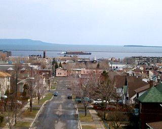
Transport in Thunder Bay is essential to trade, which has always been the backbone of the economy, beginning with Fort Kaministiquia in 1717. When the area was first settled its many waterways were used by the voyagers and Coureur des bois to trade their goods.

The Port of Albany is located within Princess Royal Harbour in King George Sound on the south coast of Western Australia, in the Great Southern region.

The CBH Group is a grain growers' cooperative that handles, markets and processes grain from the wheatbelt of Western Australia.

Fremantle Harbour is Western Australia's largest and busiest general cargo port and an important historical site. The inner harbour handles a large volume of sea containers, vehicle imports and livestock exports, cruise shipping and naval visits, and operates 24 hours a day. It is located adjacent to the city of Fremantle, in the Perth metropolitan region.

Kardarup/Mount Melville is a south-western suburb of Albany in southern Western Australia, west of Albany's central business district. Its local government area is the City of Albany.

CBH grain receival points are grain silos spread around Western Australia, primarily in the wheatbelt region. Historically they have been linked with the wheatbelt railway lines, and the transport of grain to ports for export.

Watco Australia is a rail haulage operator that was formed in 2010 to haul grain for the CBH Group in Western Australia. In 2019, it commenced operating in Queensland under a contract with GrainCorp. It is a subsidiary of Watco.
Tourist Drives in Western Australia are routes through areas of scenic or historic significance, designated by route markers with white numbers on a brown shield. Tourist Drives were introduced into Western Australia while Eric Charlton was the state government Minister for Transport in the 1990s. The 28 numbered routes collectively traverse more than 2,000 kilometres (1,200 mi) across the state. In addition to the Tourist Drives, there are unnumbered routes such as the Golden Pipeline Heritage Trail, and local governments may designate and maintain local scenic drives, generally unnamed and unnumbered.

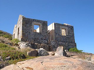
Princess Royal Fortress, also known as Albany Forts, was a fortress on the northern shore of Atatürk entrance on Princess Royal Harbour on Mount Adelaide overlooking King George Sound in Albany, Western Australia. It now operates as a museum.

York Street is the main street in the centre of Albany, Western Australia. It runs south from a junction with Albany Highway, Lockyer Avenue and Middleton Road downhill towards Princess Royal Drive and the Anzac Peace Park at the foot of the hill adjacent to Princess Royal Harbour.

Stirling Terrace, Albany is a street in the centre of Albany, Western Australia adjoining York Street.

Vancouver House, also known as the National Bank building, is a heritage listed building located on Stirling Terrace overlooking Princess Royal Harbour in Albany in the Great Southern region of Western Australia.
The coastline of the Albany area was observed by Europeans for the first time in 1627 by the Dutchman François Thijssen, captain of the ship 't Gulden Zeepaert, who sailed to the east as far as Ceduna in South Australia and back. Captain Thijssen had discovered the south coast of Australia and charted about 1,768 kilometres (1,099 mi) of it between Cape Leeuwin and the Nuyts Archipelago.

Frenchman Bay Road is a road that runs south from Albany, Western Australia.

The Fremantle Outer Harbour is the part of Fremantle Harbour located in the Cockburn Sound, at the City of Kwinana, Western Australia. Fremantle Harbour consists of the Inner Harbour, which is situated on the mouth of the Swan River; and the Outer Harbour, which is 20 kilometres (12 mi) to the south. It is managed by the Fremantle Port Authority.
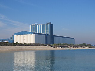
The Kwinana Grain Terminal is a grain terminal in East Rockingham, Western Australia. Built from 1969 onwards and operated by the CBH Group, the facility consists of a jetty, two horizontal storages, three silos, and four open bulk heads. Grain is transported to the site by rail, stored, and eventually loaded onto ships for export.