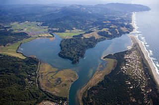
Tillamook County is a county located in the U.S. state of Oregon. As of the 2010 census, the population was 25,250. The county seat is Tillamook. The county is named for the Killamuk, an American Indian tribe who were living in the area in the early 19th century at the time of European American settlement. The county is located within Northwest Oregon.

Neskowin is an unincorporated community in Tillamook County, Oregon, United States, along the Pacific Ocean between Cascade Head and Nestucca Bay. For statistical purposes, the United States Census Bureau has defined Neskowin as a census-designated place (CDP). The census definition of the area may not precisely correspond to local understanding of the area with the same name. The population of the CDP was 134 at the 2010 census, a decrease from 169 at the 2000 census.

The Adams–Onís Treaty of 1819, also known as the Transcontinental Treaty, the Florida Purchase Treaty, or the Florida Treaty, was a treaty between the United States and Spain in 1819 that ceded Florida to the U.S. and defined the boundary between the U.S. and New Spain. It settled a standing border dispute between the two countries and was considered a triumph of American diplomacy. It came in the midst of increasing tensions related to Spain's territorial boundaries in North America against the United States and Great Britain in the aftermath of the American Revolution; it also came during the Latin American wars of independence.

Western Oregon is a geographical term that is generally taken to mean the part of the U.S. state of Oregon within 120 miles (190 km) of the Oregon Coast, on the west side of the crest of the Cascade Range. The term is applied somewhat loosely, however, and is sometimes taken to exclude the southwestern areas of the state, which are often referred to as "Southern Oregon". In that case, "Western Oregon" means only the counties west of the Cascades and north of and including Lane County.
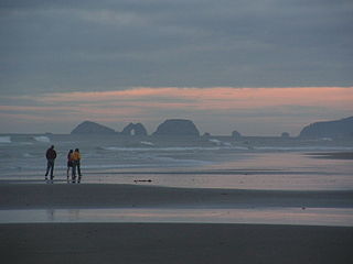
Cape Lookout is a sharp rocky promontory along the Pacific Ocean coast of northwestern Oregon in the United States. It is located in southwestern Tillamook County, approximately 10 miles (16 km) southwest of Tillamook, just south of Netarts Bay. The promontory extends 1.5 miles (2.4 km) perpendicular to the coast, and is approximately 0.5 miles (0.80 km) wide at its base, tapering as it extends outward from the coast. Cape Lookout State Park is located on the north side of the promontory, which is part of the Siuslaw National Forest. Cape Lookout Road travels past the base of the cape. Cape Lookout is a member of Tillamook's Three Capes Scenic Drive.
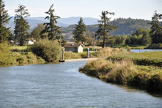
The Trask River is in northwestern Oregon in the United States. It drains a mountainous timber-producing area of the Northern Oregon Coast Range west of Portland into Tillamook Bay and the Pacific Ocean. It is one of five rivers—the Tillamook, the Trask, the Wilson, the Kilchis, and the Miami—that flow into the bay.

Cape Meares is a small headland on the Pacific coast in Tillamook County, Oregon, United States. The cape forms a high steep bluff on the south end of Tillamook Bay, approximately five miles (8 km) northwest of the city of Tillamook. Much of the cape is part of the Oregon Parks and Recreation Department-administered Cape Meares State Scenic Viewpoint with three miles of hiking trails, which includes the Cape Meares Lighthouse. The cape is named after John Meares, a British explorer.

The Nehalem River is a river on the Pacific coast of northwest Oregon in the United States, approximately 119 miles (192 km) long. It drains part of the Northern Oregon Coast Range northwest of Portland, originating on the east side of the mountains and flowing in a loop around the north end of the range near the mouth of the Columbia River. Its watershed of 855 square miles (2,210 km2) includes an important timber-producing region of Oregon that was the site of the Tillamook Burn. In its upper reaches it flows through a long narrow valley of small mountain communities but is unpopulated along most of its lower reaches inland from the coast. The city where the river flows into the Pacific is also used as the name for CPU manufacturing titan Intel's first-generation line of Core processors.

Haystack Rock is a 235-foot (72-meter) sea stack in Cannon Beach, Oregon. It is sometimes claimed locally to be the third-tallest such intertidal structure in the world, but there are no official references to support this. A popular tourist destination, the monolithic rock is adjacent to the beach and accessible by foot at low tide. The Haystack Rock tide pools are home to many intertidal animals, including starfish, sea anemone, crabs, chitons, limpets, and sea slugs. The rock is also a nesting site for many sea birds, including terns and puffins.
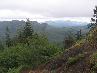
The Oregon Coast Range, often called simply the Coast Range and sometimes the Pacific Coast Range, is a mountain range, in the Pacific Coast Ranges physiographic region, in the U.S. state of Oregon along the Pacific Ocean. This north-south running range extends over 200 miles (320 km) from the Columbia River in the north on the border of Oregon and Washington, south to the middle fork of the Coquille River. It is 30 to 60 miles wide and averages around 1,500 feet (460 m) in elevation above sea level. The coast range has three main sections, a Northern, Central, and Southern.

Short Beach is a 1,000-meter stretch of beach on the northern Oregon Coast in the United States. It is not named for its length. Locals guess that both the beach and the creek that runs onto it—Short Creek, several miles in length—were named after an early resident of the area. Just south of Cape Meares State Park, and a bit north of Oceanside, the beach is hidden from the land except for a brief stretch of road which crosses the dam across Short Creek.
The Oregon Coast National Wildlife Refuge Complex consists of six National Wildlife Refuges along the Oregon Coast. It provides wilderness protection to thousands of small islands, rocks, reefs, headlands, marshes, and bays totaling 371 acres spanning 320 miles (515 km) of Oregon's coastline. The areas are all managed by the United States Fish and Wildlife Service.
The Sitka Center for Art and Ecology, located in Otis, Oregon, United States, was established in 1970 as an entity of the Neskowin Coast Foundation, which was founded May 8, 1970. The Sitka Center was established to expand the relationships between art, ecology, and humanity.
Proposal Rock may refer to:
The Bombardment of Fort Stevens occurred in June 1942, in the American Theater and the Pacific Theater of World War II. An Imperial Japanese submarine fired on Fort Stevens, which defended the Oregon side of the Columbia River's Pacific entrance.
Otis Junction is an unincorporated community in Lincoln County, Oregon, United States, at the junction of the former route of U.S. Route 101 and Oregon Route 18, a half mile south of Otis. It is a mile and a half east of where OR 18 intersects with the modern route of U.S. 101.
Necanicum is an unincorporated community in Clatsop County, Oregon, United States. It is located approximately 13 miles southeast of Seaside on U.S. Route 26 in the Northern Oregon Coast Range, next to the Necanicum River. Necanicum Junction is about a mile east of the site of the former post office, at the intersection of U.S. 26 and Oregon Route 53. It is served by the Seaside post office.

The Valley and Siletz Railroad (VS) is a 40.6-mile (65.3 km) defunct railroad located in Polk and Benton counties in the U.S. state of Oregon.

The Neskowin Ghost Forest is the remnants of a Sitka spruce forest on the Oregon Coast of the United States. The stumps were likely created when an earthquake of the Cascadia subduction zone abruptly lowered the trees, that were then covered by mud from landslides or debris from a tsunami. Many of the stumps are over 2,000 years old.
Paris is an unincorporated community in Lane County, in the U.S. state of Oregon. It is a rural locale in the Central Oregon Coast Range north of the Siuslaw River and south of the Alsea River along one of its tributaries, Five Rivers. Paris is located at 44°15′09″N123°46′14″W.


