


Protected areas in Laos include:
Protected areas in Laos include:
A National Biodiversity Conservation Area (NBCA) is an environmentally protected area in Laos. There are all together 21 different NBCAs in Laos, protecting 29,775 square kilometers. Another 10 NBCAs have been proposed, many of them being treated by authorities as though they were already officially protected.
Hin Namno National Park is in Boualapha District, Khammouane Province, Laos. The park borders Phong Nha-Kẻ Bàng National Park of Vietnam to the east and Nakai-Nam Theun National Park of Laos to the north. Hin Namno National Park was created by prime ministerial decree in January 2020. It is managed by the Ministry of Agriculture and Forestry (MAF).
Nam Et-Phou Louey National Park is a protected area in northern Laos, covering 4,107.1 km2 (1,585.8 sq mi) in three provinces: Houaphan, Luang Prabang, and Xieng Khouang. It was designated a national park in 2019, and was previously designated a national protected area. The protected area included a 3,000 km2 (1,200 sq mi) core area where human access and wildlife harvest is prohibited and a 2,950 km2 buffer area where pre-existing villages are allocated land for subsistence living.
Dong Ampham National Biodiversity Conservation Area is an extensive protected area which covers a significant part of Attapeu Province and Sekong Province in the southeast corner of Laos on the border with Vietnam. It covers the northeastern part of Attapeu Province and southeastern part of Sekong Province.

Attapeu is a province of Laos in the southeast of the country. It has five districts: Samakkixay, Xaysetha, Sanamxay, Sanxay, and Phouvong, covering an area of 10,320 square kilometres (3,980 sq mi) with a population of 127,285. Its capital city lies at Attapeu.

Bolikhamsai is a province of Laos. Pakxan, Thaphabat, Pakkading, Borikhane, Viengthong, and Khamkeut are its districts and Pakxan is its capital city. The province is the site of the Nam Theun 2 Dam, the country's largest hydroelectric project.
Xiangkhouang is a province of Laos on the Xiangkhoang Plateau, in the nation's northeast. The province has the distinction of being the most heavily bombed place on Earth.

Savannakhet is a province of Laos. The name derives from Savanh Nakhone the province's original name. It bears the same meaning as Nakhon Sawan, a city in Thailand.
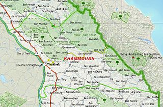
Khammouane province (Khammouan) is a province in the center of Laos. Its capital lies at Thakhek.

Salavan is a province of Laos, located in the south of the country. Its earlier name was Saravan which was changed by Thai to Salavan in 1828. It was part of the Champasak Kingdom in an area known as Muang Mang inhabited by minorities of Mon-Khmer groups.
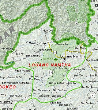
Luang Namtha is a province of Laos in the country's north. From 1966 to 1976 it formed, together with Bokeo, the province of Houakhong. Luang Namtha province covers an area of 9,325 square kilometres (3,600 sq mi). Its provincial capital is Luang Namtha. The province borders Yunnan, China to the north, Oudomxai province to the east and southeast, Bokeo province to the southwest, and Shan State, Myanmar to the northwest.

Vientiane is a prefecture of Laos, in the northwest Laos. The national capital, Vientiane, is in the prefecture. The prefecture was created in 1989, when it was split off from Vientiane province.

Luang Prabang is a province in northern Laos. Its capital of the same name, Luang Prabang, was the capital of the Lan Xang Kingdom during the 13th to 16th centuries. It is listed since 1995 by UNESCO as a World Heritage Site for unique architectural, religious and cultural heritage, a blend of the rural and urban developments over several centuries, including the French colonial influences during the 19th and 20th centuries. The province has 12 districts. The Royal Palace, the national museum in the capital city, and the Phou Loei Protected Reserve are important sites. Notable temples in the province are the Wat Xieng Thong, Wat Wisunarat, Wat Sen, Wat Xieng Muan, and Wat Manorom. The Lao New Year is celebrated in April as The Bun Pi Mai.

Champasak is a province in southwestern Laos, near the borders with Thailand and Cambodia. It is one of the three principalities that succeeded the Lao kingdom of Lan Xang. As of the 2015 census, it had a population of 694,023. The capital is Pakse, but the province takes its name from Champasak, the former capital of the Kingdom of Champasak.
Phou Xieng Thong National Protected Area is a national protected area in Salavan and Champasak provinces of southern Laos. This park, the country's only park on the Mekong river, is home to a wide variety of animal and plant species, some endangered. The park is an ecotourism destination.

Phou Khao Khouay National Park is a protected area in Laos. It is located 40 kilometres (25 mi) northeast of Vientiane. It covers an area of 1920 km2, extending into Xaisomboun Province, Vientiane Prefecture, Vientiane Province, and Bolikhamsai Province. It was established on 29 October 1993 as Phou Khao Khouay National Biodiversity Conservation Area, and redesignated a national park in 2021. It includes a large stretch of mountain range with sandstone cliffs, river gorges and three large rivers with tributaries which flow into the Mekong River.
Phou Den Din National Protected Area or National Biodiversity Conservation Area (NBCA) is a protected area in northern Laos, covering 2,200 km2 in Phongsaly Province. It was designated a National Biodiversity Conservation Area in 1993. The name is also spelt Phou Dene Dinh and Phou Daen Din. The conservation area borders Vietnam, and its terrain is hilly, rising to over 2,000 meters. Among the animals found in the area are elephants, gibbons, macaques, gaurs, bantengs, Asiatic black bears, sun bears, leopards, and tigers. It also has a high density of lesser fish eagles and crested kingfishers. The area is not easily accessible, but can be reached by boat or on foot.

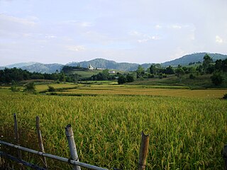
The Luang Prabang montane rain forests ecoregion covers elevations over 800 meters in the Luang Prabang mountains that straddle the border between northern Thailand and north-central Laos, and the highlands that stretch eastward across north-central Laos. While much of the forest cover has been degraded, there are still large areas of relatively untouched forest.

The Northern Annamites rain forests ecoregion covers the rugged and relatively unexplored northern Annamite Mountains of central Laos and Vietnam. There are high numbers of endemic plant species, and the relative remoteness and isolation of the area supports many rare and endangered animals. Rainfall is somewhat less than the lowland rainforest of the lower elevations in Vietnam, and the temperatures slightly cooler due to the higher elevation.
Beung Kiat Ngong Wetlands is located in Champassak Province, southern Laos. Wetland complex is made up of diverse wetland types, including lakes, swamps, peat lands and marshes.