A National Biodiversity Conservation Area (NBCA) is an environmentally protected area in Laos. There are all together 21 different NBCAs in Laos, protecting 29,775 square kilometers. Another 10 NBCAs have been proposed, many of them being treated by authorities as though they were already officially protected.

Indawgyi Lake is one of the largest inland lakes in Southeast Asia. It is located in Mohnyin Township in the Kachin State of Myanmar. The lake measures 13 kilometres (8.1 mi) east to west, and 24 kilometres (15 mi) north to south. There are over 20 villages around the lake. The predominant ethnic groups living in the surroundings of the lake are the Shan and the Kachin, who mainly practise agriculture. It is 546 feet (166 m) above sea level. The lake is the main feature of the Indawgyi Lake Wildlife Sanctuary.
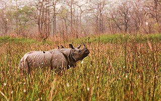
Orang National Park is a national park in India located on the northern bank of the Brahmaputra River in the Darrang and Sonitpur districts of Assam. It covers an area of 79.28 km2 (30.61 sq mi). It was established as a sanctuary in 1985 and declared a national park on 13 April 1999. It is rich in flora and fauna, including great Indian rhinoceros, pygmy hog, Asian elephant, wild water buffalo and the Bengal tiger. It is the only stronghold of the rhinoceros on the north bank of the Brahmaputra.

The wildlife of Chad is composed of its flora and fauna. Bush elephants, West African lions, buffalo, hippopotamuses, Kordofan giraffes, antelopes, African leopards, cheetahs, hyenas, and many species of snakes are found there, although most large carnivore populations have been drastically reduced since the early 20th century. Elephant poaching, particularly in the south of the country in areas such as Zakouma National Park, is a severe problem.

The state of Karnataka in South India has a rich diversity of flora and fauna. It has a recorded forest area of 38,720 km2 which constitutes 22% of the geographical area of the state. These forests support 25% of the elephant population and 20% of the tiger population of India. Many regions of Karnataka are still unexplored and new species of flora and fauna are still found. The mountains of the Western Ghats in the western region of Karnataka are a biodiversity hotspot. Two sub-clusters of the Western Ghats, Talacauvery and Kudremukh, are on a tentative list of sites that could be designated as World Heritage Sites by UNESCO. The Bandipur and Nagarahole national parks which fall outside these subclusters were included in the Nilgiri biosphere reserve in 1986, a UNESCO designation. In the Biligiriranga Hills the Eastern Ghats meet the Western Ghats. The state bird and state animal of Karnataka are Indian roller and the Indian elephant. The state tree and state flower are sandalwood and lotus. Karnataka is home to 524 tigers.

Tanzania contains some 20 percent of the species of Africa's large mammal population, found across its reserves, conservation areas, marine parks, and 17 national parks, spread over an area of more than 42,000 square kilometres (16,000 sq mi) and forming approximately 38 percent of the country's territory. Wildlife resources of Tanzania are described as "without parallel in Africa" and "the prime game viewing country". Serengeti National Park, the country's second largest national park area at 14,763 square kilometres (5,700 sq mi), is located in northern Tanzania and is famous for its extensive migratory herds of wildebeests and zebra while also having the reputation as one of the great natural wonders of the world. The Ngorongoro Conservation Area, established in 1959, is a UNESCO World Heritage Site and inhabited by the Maasai people. Its Ngorongoro Crater is the largest intact caldera in the world.
Dong Ampham National Biodiversity Conservation Area is an extensive protected area which covers a significant part of Attapeu Province and Sekong Province in the southeast corner of Laos on the border with Vietnam. It covers the northeastern part of Attapeu Province and southeastern part of Sekong Province.

Attapeu is a province of Laos in the southeast of the country. It has five districts: Samakkixay, Xaysetha, Sanamxay, Sanxay, and Phouvong, covering an area of 10,320 square kilometres (3,980 sq mi) with a population of 127,285. Its capital city lies at Attapeu.

Bolikhamsai is a province of Laos. Pakxan, Thaphabat, Pakkading, Borikhane, Viengthong, and Khamkeut are its districts and Pakxan is its capital city. The province is the site of the Nam Theun 2 Dam, the country's largest hydroelectric project.
Sekong is a province of Laos in the southeast of the country.
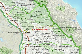
Khammouane province (Khammouan) is a province in the center of Laos. Its capital lies at Thakhek.

Salavan is a province of Laos, located in the south of the country. Its earlier name was Saravan which was changed by Thai to Salavan in 1828. It was part of the Champasak Kingdom in an area known as Muang Mang inhabited by minorities of Mon-Khmer groups.

Saiyabuli province is a province in northwest Laos. Saiyabuli town is the capital of the province. Saiyabuli is the only Lao province that is completely west of the Mekong River.

Champasak is a province in southwestern Laos, near the borders with Thailand and Cambodia. It is one of the three principalities that succeeded the Lao kingdom of Lan Xang. As of the 2015 census, it had a population of 694,023. The capital is Pakse, but the province takes its name from Champasak, the former capital of the Kingdom of Champasak.
Nam Ha National Protected Area is a national protected area in Luang Namtha Province in northern Laos. This mostly forested park is home to a variety of ethnic groups and diverse animal and plant species. The park is an ecotourism destination.
Phou Xieng Thong National Protected Area is a national protected area in Salavan and Champasak provinces of southern Laos. This park, the country's only park on the Mekong river, is home to a wide variety of animal and plant species, some endangered. The park is an ecotourism destination.
Dong Hua Sao National Protected Area is a national park in Champasak Province in southern Laos. This forested park rises from the Mekong river lowlands eastwards into the Bolaven Plateau. It is an ecotourism destination.
Phou Xang He National Protected Area is a national protected area in Savannakhet Province in central Laos. This mostly pristine forested park is home to a large variety of important animal and bird species. The park is home to the Phu Tai and Katang ethnic groups and is an ecotourism destination.
Dong Phou Vieng National Protected Area is a national protected area in Savannakhet Province in central Laos. This mostly forested park is home to large variety of animal species and contains part of the former Ho Chi Minh trail. The park is home to the Katang ethnic group and is an ecotourism destination.
Nam Kading National Protected Area is a national protected area in Bolikhamsai Province in central Laos. This rugged and largely inaccessible park, cut through by its namesake Nam Kading river, is home to a wide variety of plant and animal species, some endangered. Due to its ruggedness, the park lacks any significant human settlement.


