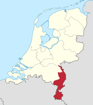
Limburg, also known as Dutch Limburg, is the southernmost of the twelve provinces of the Netherlands. It is bordered by Gelderland to the north and by North Brabant to its west. Its long eastern boundary forms the international border with the state of North Rhine-Westphalia in Germany. To the west is the international border with the similarly named Belgian province of Limburg, part of which is delineated by the river Meuse. To the south, Limburg is bordered by the Belgian province of Liège. The Vaalserberg is on the extreme southeastern point, marking the tripoint of the Netherlands, Germany and Belgium.

The Meuse or Maas is a major European river, rising in France and flowing through Belgium and the Netherlands before draining into the North Sea from the Rhine–Meuse–Scheldt delta. It has a total length of 925 km.

William I was King of the Netherlands and Grand Duke of Luxembourg from 1815 until his abdication in 1840.

The United Kingdom of the Netherlands is the unofficial name given to the Kingdom of the Netherlands as it existed between 1815 and 1830. The United Netherlands was created in the aftermath of the Napoleonic Wars through the fusion of territories that had belonged to the former Dutch Republic, Austrian Netherlands, and Prince-Bishopric of Liège in order to form a buffer state between the major European powers. The polity was a constitutional monarchy, ruled by William I of the House of Orange-Nassau.

Limburg, also known as Belgian Limburg, is a province in Belgium. It is the easternmost of the five Dutch-speaking provinces that together form the Region of Flanders, which is one of the three main political and cultural sub-divisions of modern-day Belgium. As of January 2024, Limburg had a population of 0.9 million.

Roermond is a city, municipality, and diocese in the Limburg province of the Netherlands. Roermond is a historically important town on the lower Roer on the east bank of the river Meuse. It received town rights in 1231. Roermond's town centre has become a designated conservation area.

The Southern Netherlands, also called the Catholic Netherlands, were the parts of the Low Countries belonging to the Holy Roman Empire which were at first largely controlled by Habsburg Spain and later by the Austrian Habsburgs until occupied and annexed by Revolutionary France (1794–1815).

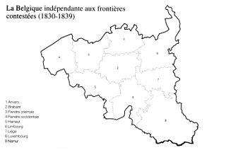
The Treaty of London of 1839, was signed on 19 April 1839 between the major European powers, the United Kingdom of the Netherlands and the Kingdom of Belgium. It was a direct follow-up to the 1831 Treaty of the XVIII Articles, which the Netherlands had refused to sign, and the result of negotiations at the London Conference of 1838–1839 which sought to maintain the Concert of Europe.

The Belgian Revolution was the conflict which led to the secession of the southern provinces from the United Kingdom of the Netherlands and the establishment of an independent Kingdom of Belgium.

Meuse-Inférieure was a department of the French First Republic and French First Empire in present-day Belgium, Netherlands and Germany. It was named after the river Meuse. Its territory corresponded largely with the present-day provinces of Belgian and Dutch Limburg. It was created on 1 October 1795, when the Austrian Netherlands and the Prince-Bishopric of Liège were officially annexed by the French Republic. Before this annexation, its territory was part of the County of Loon, the Austrian Upper Guelders, the Staats-Oppergelre, the County of Horne, the Abbacy of Thorn, Maastricht and part of the Lands of Overmaas. The lands of the original medieval Duchy of Limburg were associated with the Overmaas lands, lying to their south. The two regions had long been governed together and referred to collectively with both names, but the original Duchy lands were not part of this new entity.

The Spanish Netherlands was the Habsburg Netherlands ruled by the Spanish branch of the Habsburgs from 1556 to 1714. They were a collection of States of the Holy Roman Empire in the Low Countries held in personal union by the Spanish Crown. This region comprised most of the modern states of Belgium and Luxembourg, as well as parts of northern France, the southern Netherlands, and western Germany, with the capital being Brussels. The Army of Flanders was given the task of defending the territory.

The Duchy of Limburg or Limbourg was an imperial estate of the Holy Roman Empire. Much of the area of the duchy is today located within Liège Province of Belgium, with a small portion in the municipality of Voeren, an exclave of the neighbouring Limburg Province. Its chief town was Limbourg-sur-Vesdre, in today's Liège Province.
The Generality Lands, Lands of the Generality or Common Lands were about one-fifth of the territories of the United Provinces of the Netherlands, that were directly governed by the States-General. Unlike the seven provinces of Holland, Zeeland, Utrecht, Guelders, Overijssel, Friesland and Groningen, these territories had no States-Provincial and were not represented in the central government. At the time of the Union of Utrecht, these territories were under Spanish control, and would only be conquered by the Dutch Republic later in the war. From an economic point of view, they were exploited with heavy taxes and levies.

There were three Partitions of Luxembourg between 1659 and 1839. Together, the three partitions reduced the territory of the Duchy of Luxembourg from 10,700 km2 (4,100 sq mi) to the present-day area of 2,586 km2 (998 sq mi) over a period of 240 years. The remainder forms parts of modern-day Belgium, France, and Germany.

The Duchy of Limburg was created in 1839 from parts of the Dutch Province of Limburg as a result of the Treaty of London. Its territory was the territory of the modern day province of Limburg with the exceptions of the cities of Maastricht and Venlo. The Duchy of Limburg was also a member state of the German Confederation.
The Arrondissement of Maastricht was an arrondissement of the United Kingdom of the Netherlands until the Treaty of London in 1839. It was a part of the Province of Limburg, which also included the arrondissements of Hasselt and Roermond. It was centred on the city of Maastricht.

Upper Guelders or Spanish Guelders was one of the four quarters in the Imperial Duchy of Guelders. In the Dutch Revolt, it was the only quarter that did not secede from the Habsburg monarchy to become part of the Seven United Netherlands, but remained under Spanish rule during the Eighty Years' War.

The Belgian province of Limburg in Flanders is a region which has had many names and border changes over its long recorded history. Its modern name is a name shared with the neighbouring province of the Netherlands, with which it was for a while politically united. The two provinces received their modern name after 1815, based upon the name of the medieval Duchy of Limburg, which had actually been in what is now neighbouring Wallonia, centred upon the town of Limbourg on the Vesdre.

In the early 19th century, the Grand Duchy of Luxembourg was ruled in personal union by the King of the Netherlands, William I. The territory that is now Belgium was similarly part of the United Kingdom of the Netherlands. When the Belgian Revolution occurred in 1830, most of Luxembourg rallied to this Revolution, and accepted Belgian rule. The exception was the fortress and capital, Luxembourg City, which housed a Dutch-German garrison and remained loyal to William I. This led to a de facto separation of the country from 1830-1839, when most of it was loyal to and administered by Belgium, while one part retained allegiance to the Netherlands. The situation was resolved in 1839 when the international great powers and William I agreed that Luxembourg would remain in his possession, and lose its French-speaking parts to the new country of Belgium.


