The economy of Turkey is an emerging free-market economy. It ranked as the 17th-largest in the world and 7th-largest in Europe by nominal GDP in 2024. It also ranked as the 12th-largest in the world and 5th-largest in Europe by PPP in 2024. Turkey's rapid economic growth since the 2000s was stranded by the economic crisis in 2018, but it began to recover in 2021. Turkey's USD-based nominal GDP per capita and GDP-PPP per capita have eventually reached their all-time peak values in 2024. The country is expected to become a high-income economy in a few years.

Transport in Turkey is road-dominated and mostly fuelled by diesel. Transport consumes a quarter of energy in Turkey, and is a major source of air pollution in Turkey and greenhouse gas emissions by Turkey. The World Health Organization has called for more active transport such as cycling. As of 2023 health impact assessment is not done in Turkey.

Beşiktaş is a district and municipality of Istanbul Province, Turkey. Its area is 18 km2 and its population is 175,190 (2022). It is located on the European shore of the Bosphorus strait. It is bordered on the north by Sarıyer and Şişli, on the west by Kağıthane and Şişli, on the south by Beyoğlu, and on the east by the Bosphorus. Directly across the Bosphorus is the district of Üsküdar.

The Coast Guard Command is the coast guard service of Turkey. The Turkish Coast Guard is under the command of the Ministry of the Interior. However, during wartime some of its elements can be subordinated to Turkish Naval Forces by the President.

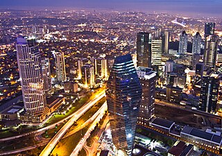
Istanbul is the largest city in Turkey, straddling the Bosporus Strait, the boundary between Europe and Asia. It is considered the country's economic, cultural and historic capital. The city has a population of over 15 million residents, comprising 19% of the population of Turkey, and is the most populous city in Europe and the world's sixteenth-largest city.

Turkish State Railways (TCDD) started building high-speed rail lines in 2003. TCDD has branded its high-speed service as Yüksek Hızlı Tren (YHT) which currently operates on three lines: the Ankara–Istanbul high-speed railway, the Ankara–Konya high-speed railway and the Ankara-Sivas high-speed railway. YHT is the only high-speed rail service in Turkey, with two types of EMU train models operating at speeds of up to 250 km/h (155 mph) (HT65000) or 300 km/h (186 mph) (HT80000).

The Istanbul Metro is a rapid transit railway network that serves the city of Istanbul, Turkey. Apart from the M11 line, which is operated by TCDD Taşımacılık, the system is operated by Metro Istanbul, a public enterprise controlled by the Istanbul Metropolitan Municipality. The oldest section of the metro is the M1 line, which opened on 3 September, 1989. As of 2024, the system now includes 159 stations in service, with 36 more under construction. With 243.3 kilometers, Istanbul has the 21st longest metro line in the world and the 4th longest in Europe as of 2024.

Otoyol 31, named the İzmir-Denizli Motorway and abbreviated as the O-31 is a 127.8 km (79.4 mi) long toll motorway in western Turkey. Beginning at an intersection with İzmir Beltway, the O-31 runs south from İzmir to Aydın and parallels the D550 for most of its route.

The General Directorate of Security or the Turkish National Police, abbreviated TNP, is the national civil police of Turkey primarily responsible for law enforcement in urban areas, whilst rural policing falls under the jurisdiction of the Gendarmerie General Command. The TNP reports to the Ministry of the Interior and is composed of 81 divisions, each for respective provinces, that make up several police regions that are bolstered by specialist units.
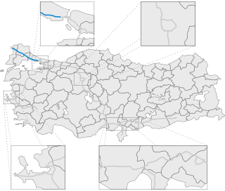
Otoyol 3, also known as the European Motorway and abbreviated as the O-3 is a 245.1 km (152.3 mi) long otoyol in East Thrace, Turkey. The O-3 runs from Edirne to Istanbul and is the only motorway in Turkey located entirely in Europe. The motorway begins west of Edirne at "Edirne Batı K1" junction with the D.100 where it then continues as a beltway passing just north of Edirne. From there, the motorway passes through mostly rural farmland until it enters the Istanbul metropolis near Silivri. The eastern end of O-3 ends at the Istanbul Bağcılar "Mahmutbey Batı K20" Junction.

The General Directorate Of Highways (KGM) is a state agency responsible for the construction and maintenance of all public roadways outside of cities and towns in Turkey. It was established on 1 March 1950, following the enactment of the International Highways Act in 1949. The agency operates as a subsidiary of the Ministry of Transport and Infrastructure.

Otoyol 50, abbreviated as O-50, aka Adana Çevreyolu, was the former designation for the 22 km (14 mi) long motorway passing through the city of Adana, Turkey. In the 2014 the KGM resigned the section of motorway west of the Seyhan River as the O-51 and the section west of the Seyhan River as O-52. Thus extending the O-52 and O-51 into central Adana.
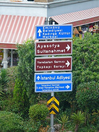
Road signs in Turkey conform to the general pattern of those used in most other European countries and to those set out in the Vienna Convention on Road Signs and Signals. They are regulated in the Trafik İşaretleri Elkitabi.

The provincical road is a connector route linking the motorway O-1 to the motorway O-2.
D.505 is a 54-kilometre-long (34 mi), two-lane state road on the Karaburun Peninsula, in İzmir Province of western Turkey. The route runs from Karaburun at the tip of the peninsula to the intersection with the D300 near Gülbahçe. Traffic on the D505 is heavy during holidays, especially in the summer, due to the many vacation homes situated along the route.
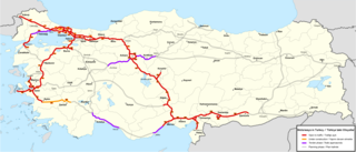
The Otoyol is the national network of controlled-access highways in Turkey. The term Otoyol translates to motorway while the literal meaning is auto-route. The Otoyol was first opened in 1973.

The Otoyol 7, or Northen Marmara Motorway(Turkish: Kuzey Marmara Otoyolu), is a toll motorway in Turkey that bypasses Istanbul to the north. The motorway is 248 km in length between the Kınalı junction and the Akyazı junction, and is 8 lanes wide .Within the scope of the Build-Operate-Transfer Model Construction, Operation and Transfer of Kınalı-Odayeri Section and Kurtköy-Akyazı Section of the Northern Marmara Motorway Project, it is composed of two separate authorized companies, namely "AVRUPA OTOYOLU YATIRIM VE İŞLETME AŞ". on the European side and "KMO ANADOLU OTOYOLU İŞLETME AŞ". on the Asian side.
