
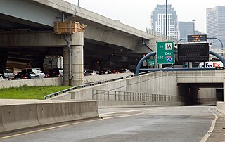
The Big Dig was a megaproject in Boston that rerouted the then elevated Central Artery of Interstate 93 that cut across Boston into the O'Neill Tunnel and built the Ted Williams Tunnel to extend Interstate 90 to Logan International Airport. Those two projects were the origin of the official name, the Central Artery/Tunnel Project. Additionally, the project constructed the Zakim Bunker Hill Bridge over the Charles River, created the Rose Kennedy Greenway in the space vacated by the previous I-93 elevated roadway, and funded more than a dozen projects to improve the region's public transportation system. Planning for the project began in 1982; the construction work was carried out between 1991 and 2006; and the project concluded on December 31, 2007. The project's general contractor was Bechtel and Parsons Brinckerhoff was the engineer, who worked as a consortium, both overseen by the Massachusetts Highway Department.

Interstate 93 (I-93) is an Interstate Highway in the New England states of Massachusetts, New Hampshire, and Vermont in the United States. Spanning approximately 190 miles (310 km) along a north–south axis, it is one of three primary Interstate Highways located entirely within New England; the other two are I-89 and I-91. The largest cities along the route are Boston, and Manchester, New Hampshire; it also travels through the New Hampshire state capital of Concord.

The Massachusetts Turnpike is a controlled-access toll highway in the US state of Massachusetts that is maintained by the Massachusetts Department of Transportation (MassDOT). It is concurrent with the entirety of Interstate 90 (I-90) within the state, and is the longest Interstate Highway in Massachusetts, spanning 138 miles (222 km) along an east–west axis.
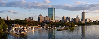
Back Bay is an officially recognized neighborhood of Boston, Massachusetts, built on reclaimed land in the Charles River basin. Construction began in 1859, as the demand for luxury housing exceeded the availability in the city at the time, and the area was fully built by around 1900. It is most famous for its rows of Victorian brownstone homes—considered one of the best preserved examples of 19th-century urban design in the United States—as well as numerous architecturally significant individual buildings, and cultural institutions such as the Boston Public Library, and Boston Architectural College. Initially conceived as a residential-only area, commercial buildings were permitted from around 1890, and Back Bay now features many office buildings, including the John Hancock Tower, Boston's tallest skyscraper. It is also considered a fashionable shopping destination and home to several major hotels.

Copley Place is an enclosed shopping mall in the Back Bay neighborhood of Boston, Massachusetts. It is named after the nearby Copley Square, and is connected to the Prudential Center shopping mall via a skybridge over Huntington Avenue.
Route 9 is a 135.310-mile-long (217.760 km) major east–west state highway in Massachusetts, United States. Along with U.S. Route 20, Route 2, and Interstate 90, Route 9 is one of the major east–west routes of Massachusetts. The western terminus is near the center of the city of Pittsfield. After winding through the small towns along the passes of the Berkshire Mountains, it crosses the college towns of the Pioneer Valley and then south of the Quabbin Reservoir and the rural areas of western Worcester County. Entering the city of Worcester from the southwestern corner of the city, it passes through the center of the city and forms the major commercial thoroughfare through the MetroWest suburbs of Boston, parallel to the Massachusetts Turnpike. Crossing the Route 128 freeway circling Boston, it passes through the inner suburbs of Newton and Brookline along Boylston Street, and enters Boston on Huntington Avenue, before reaching its eastern terminus at Copley Square.

The Prudential Tower, also known as the Prudential Building or, colloquially, the Pru, is an international style skyscraper in Boston, Massachusetts. The building, a part of the Prudential Center complex, currently stands as the 2nd-tallest building in Boston, behind the John Hancock Tower. The Prudential Tower was designed by Charles Luckman and Associates for Prudential Insurance. Completed in 1964, the building is 749 feet (228 m) tall, with 52 floors, and is tied with others as the 114th-tallest in the United States. It contains 1.2 million sq ft (110,000 m2) of commercial and retail space. Including its radio mast, the tower's pinnacle height reaches 907 feet (276 m).
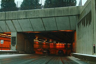
The Ted Williams Tunnel is a highway tunnel in Boston, Massachusetts. The third in the city to travel under Boston Harbor, with the Sumner Tunnel and the Callahan Tunnel, it carries the final segment of Interstate 90 from South Boston towards its eastern terminus at Route 1A in East Boston, slightly beyond Logan International Airport. The tunnel is named after the Boston Red Sox baseball legend Ted Williams.

The Lieutenant William F. Callahan Jr. Tunnel is one of four tunnels, and one of three road tunnels, beneath Boston Harbor in Boston, Massachusetts. It carries motor vehicles from the North End to Logan International Airport and Route 1A in East Boston. Ordinarily, this tunnel is only used to carry traffic out of the city, and with the completion of the Big Dig it only collects traffic from I-93 southbound and downtown Boston; northbound traffic uses the Ted Williams Tunnel. As of 2016, a toll of $1.50 is charged for non-commercial two-axle vehicles with a Massachusetts E-ZPass, while non-Massachusetts E-ZPass holders are charged $1.75. Vehicles without E-ZPass are charged $2.05 through MassDOT's Pay By Plate MA program. For residents of certain Boston ZIP codes, a discount is in effect using an E-ZPass transponder, costing $0.20.

The Sumner Tunnel is a road tunnel in Boston, Massachusetts, United States. It carries traffic under Boston Harbor in one direction, from Logan International Airport and Route 1A in East Boston. The tunnel originally deposited traffic at the west side of the North End, but with the completion of the Big Dig, it was modified to have two exits. One exit connects to I-93 northbound and downtown Boston near Haymarket Station. The other exit connects to Storrow Drive and Nashua St., connecting Cambridge via Route 28. Traffic headed for I-93 southbound and the Massachusetts Turnpike (I-90) westbound is normally routed to the Ted Williams Tunnel. It is managed by the Massachusetts Department of Transportation.
Fast Lane was the original branding for the electronic toll collection system used on toll roads in Massachusetts, including the Massachusetts Turnpike, Sumner Tunnel, Ted Williams Tunnel, and Tobin Bridge. It was introduced in 1998, and later folded into the E-ZPass branding in 2012. Fast Lane transponders were fully interoperable with member agencies of the E-ZPass Interagency Group, however Fast Lane transponders afford users discounted tolls in some junctions that out-of-state users are not offered.

Hynes Convention Center station is an underground light rail station on the Massachusetts Bay Transportation Authority (MBTA) Green Line. It is located at the intersection of Newbury Street and Massachusetts Avenue near the western end of the Back Bay neighborhood of Boston, Massachusetts. The station is named for the Hynes Convention Center, which is located about 700 feet (210 m) to the east along Boylston Street. It has two side platforms serving the two tracks of the Boylston Street subway, which are used by the Green Line B branch, C branch, and D branch. The main entrance to the station from Massachusetts Avenue leads to a fare lobby under the 360 Newbury Street building.
The Central Artery is a section of freeway in downtown Boston, Massachusetts; it is designated as Interstate 93, US 1 and Route 3.
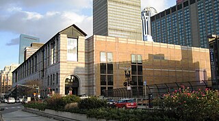
The John B. Hynes Veterans Memorial Convention Center is a convention center located in Boston, Massachusetts. It was built in 1988 from a design by architects Kallmann, McKinnell & Wood. It replaced the John B. Hynes Memorial Auditorium, also a convention center, built in 1963 during the Massachusetts Turnpike expansion from Route 128 to the Central Artery, which was regarded as "ungainly". The 1988 design "attempted to relate in scale and materials to its Back Bay setting, adopting granite and setbacks. The severe gray interior is reminiscent of an early 20th-century German railroad station". The Center is named after former Boston mayor John Hynes.
The Big Dig ceiling collapse occurred on July 10, 2006, when a concrete ceiling panel and debris weighing 26 short tons and measuring 20 by 40 feet fell in Boston's Fort Point Channel Tunnel. The panel fell on a car traveling on the two-lane ramp connecting northbound I-93 to eastbound I-90 in South Boston, killing a passenger and injuring the driver. Investigation and repair of the collapse caused a section of the Big Dig project to be closed for almost a full year, causing chronic traffic backups.
The South Bay Interchange is a massive interchange in downtown Boston, Massachusetts, in the US. The interchange consists of Interstate 90, the Mass Pike Extension, and the Interstate 93 concurrency with US 1 and MA 3 south of the Thomas P. O'Neill Jr. Tunnel.
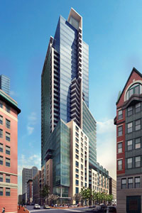
101 Clarendon Street, also known as Columbus Center, was a proposed skyscraper planned for Boston, Massachusetts. If completed, it would have stood as the 25th-tallest building in Boston. Continuing on the trend established by the Prudential Tower in 1964, the completed building would have concealed more of the Massachusetts Turnpike (I-90) by utilizing air rights above it. The location would have been above the turnpike, directly to the east of Back Bay station and south of Copley Square in the Back Bay neighborhood of Boston. The project would have "united the city’s Back Bay and South End neighborhoods."

U.S. Route 1 (US 1) is a major north–south U.S. Route in the state of Massachusetts, traveling through Essex, Middlesex, Suffolk, Norfolk, and Bristol counties. The portion of US 1 south of Boston is also known as the Boston–Providence Turnpike, Washington Street, or the Norfolk and Bristol Turnpike, and portions north of Boston are known as the Northeast Expressway and the Newburyport Turnpike.
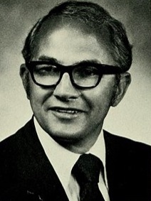
Allan Robert McKinnon was a Massachusetts politician who served as a member of the Massachusetts State Senate from 1971 to 1985, Deputy Secretary of Transportation from 1985 to 1988, and Chairman of the Massachusetts Turnpike Authority from 1988 to 1996. He retired in 1996.
The architecture of Boston is a robust combination of old and new architecture. As one of the oldest cities in North America, Boston, Massachusetts has accumulated buildings and structures ranging from the 17th-century to the present day, having evolved from a small port town to a large cosmopolitan center for education, industry, finance, and technology. The city is known for its granite buildings stemming from its early days. It is also known for being one of the origins of Federal Architecture.

