Przekop

Last updated
Przekop Wisly Poland Mikoszewo - Vistula Przekop Wisly.jpg
Przekop Wisły

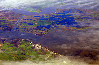
Przekop (Polish pronunciation:  [ˈpʂɛkɔp] ), (German: Weichseldurchstich) located in Poland, is a branch of the Vistula river in its delta. It is also referred to as Przekop Wisły, which translates literally as Vistula Dug-through from Polish.

Poland Republic in Central Europe

Poland, officially the Republic of Poland, is a country located in Central Europe. It is divided into 16 administrative subdivisions, covering an area of 312,696 square kilometres (120,733 sq mi), and has a largely temperate seasonal climate. With a population of approximately 38.5 million people, Poland is the sixth most populous member state of the European Union. Poland's capital and largest metropolis is Warsaw. Other major cities include Kraków, Łódź, Wrocław, Poznań, Gdańsk, and Szczecin.

Vistula river in Eastern Europe

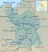
The Vistula, the longest and largest river in Poland, is the 9th-longest river in Europe, at 1,047 kilometres in length. The drainage-basin area of the Vistula is 193,960 km2 (74,890 sq mi), of which 168,868 km2 (65,200 sq mi) lies within Poland. The remainder lies in Belarus, Ukraine and Slovakia.

River delta Silt deposition landform at the mouth of a river

A river delta is a landform created by deposition of sediment that is carried by a river as the flow leaves its mouth and enters slower-moving or stagnant water. This occurs where a river enters an ocean, sea, estuary, lake, reservoir, or another river that cannot carry away the supplied sediment. The size and shape of a delta is controlled by the balance between watershed processes that supply sediment, and receiving basin processes that redistribute, sequester, and export that sediment. The size, geometry, and location of the receiving basin also plays an important role in delta evolution. River deltas are important in human civilization, as they are major agricultural production centers and population centers. They can provide coastline defense and can impact drinking water supply. They are also ecologically important, with different species' assemblages depending on their landscape position.

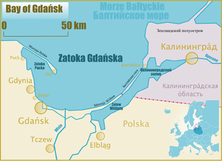
It was artificially created in 1895 to link the Leniwka branch with Gdańsk Bay near the village of Świbno. [1] Currently, the main current of the Vistula reaches the sea through Przekop.

Leniwka river, Poland

The Leniwka is a river in northern Poland, one of the branches of the Vistula. It is 55.4 kilometres (34.4 mi) long, and flows into Gdańsk Bay, forming the southern border of Ostrów Island and Sobieszewo Island.

Related Research Articles

Sobieszewo Island Gdańsk District in Pomeranian, Poland

Sobieszewo Island is an island on the Baltic sea, between the Gdańsk Bay and the delta of Vistula river. The island is part of the territory of the city of Gdańsk, Poland.

Gdańsk Bay the bay in the Baltic Sea adjoining the port of Gdańsk and stretching to Kaliningrad

Gdansk Bay or the Bay of Gdansk Polish: Zatoka Gdańska; Kashubian: Gduńskô Hôwinga; Russian: Гданьская бухта, Gdan'skaja bukhta, and German: Danziger Bucht) is a southeastern bay of the Baltic Sea. It is named after the adjacent port city of Gdańsk in Poland and is sometimes referred to as the Gulf of Gdańsk.

Pregolya River river in Kaliningrad Oblast, Russia

The Pregolya or Pregola is a river in the Russian Kaliningrad Oblast exclave.

The Śmiała Wisła is a distributary river branch of the Vistula in Poland flowing to Gdańsk Bay.

Vistula Spit peninsular stretch of land

The Vistula Spit is an aeolian sand spit, or peninsular stretch of land, which separates Vistula Lagoon from Gdańsk Bay in the Baltic Sea, with its tip separated from the mainland by the Strait of Baltiysk. The border between Poland and Kaliningrad Oblast, an exclave of Russia, bisects it, politically dividing the spit in half between the two countries. The westernmost point of Russia is located on the Vistula Spit. The Polish part contains a number of tourist resorts, incorporated administratively as the town of Krynica Morska.

Sztutowo Village in Pomeranian, Poland

Sztutowopronounced [ʂtuˈtɔvɔ] is a village in Nowy Dwór Gdański County, part of the Pomeranian Voivodeship of Poland. It is located about 38 km (24 mi) east of Gdańsk on the northeastern edge of the Vistula Delta, at the base of the Vistula Spit on the Baltic coast.

Kampinos Forest

Kampinos Forest is a large forest complex located in Masovian Voivodeship, west of Warsaw in Poland.

Bisztynek Place in Warmian-Masurian, Poland

Bisztynek is a town in Bartoszyce County, Warmian-Masurian Voivodeship, Poland, with 2,418 inhabitants (2016).

Młynary Place in Warmian-Masurian, Poland

Młynary is a town in Elbląg County, Warmian-Masurian Voivodeship, Poland, with 1,792 inhabitants (2017). This makes it the smallest of the 49 towns in the voivodeship.

Odra, Silesian Voivodeship Village in Silesian, Poland

Odra is a village in Gmina Gorzyce, Wodzisław County, Silesian Voivodeship, Poland. It has a population of 391 (2006) and is situated on the Odra River.

Roman Catholic Archdiocese of Gdańsk

The Archdiocese of Gdańsk is an archdiocese located in the city of Gdańsk in Poland.

Kotłówka, Masovian Voivodeship Village in Masovian, Poland

Kotłówka is a village in the administrative district of Gmina Żelechów, within Garwolin County, Masovian Voivodeship, in east-central Poland. It lies approximately 3 kilometres (2 mi) east of Żelechów, 24 km (15 mi) south-east of Garwolin, and 80 km (50 mi) south-east of Warsaw.

Konstantynówek is a settlement in the administrative district of Gmina Ślesin, within Konin County, Greater Poland Voivodeship, in west-central Poland.

Biała Podlaska, Warmian-Masurian Voivodeship Village in Warmian-Masurian, Poland

Biała Podlaska is a village in the administrative district of Gmina Bartoszyce, within Bartoszyce County, Warmian-Masurian Voivodeship, in northern Poland, close to the border with the Kaliningrad Oblast of Russian Federation. It lies approximately 11 kilometres (7 mi) west of Bartoszyce and 51 km (32 mi) north of the regional capital Olsztyn.

Młyniec is a settlement in the administrative district of Gmina Lelkowo, within Braniewo County, Warmian-Masurian Voivodeship, in northern Poland, close to the border with the Kaliningrad Oblast of Russia.

Kuty, Warmian-Masurian Voivodeship Village in Warmian-Masurian, Poland

Kuty is a village in the administrative district of Gmina Pozezdrze, within Węgorzewo County, Warmian-Masurian Voivodeship, in northern Poland. It lies approximately 7 kilometres (4 mi) north-east of Pozezdrze, 14 km (9 mi) east of Węgorzewo, and 104 km (65 mi) north-east of the regional capital Olsztyn.

Wesoła, West Pomeranian Voivodeship Settlement in West Pomeranian, Poland

Wesoła is a settlement in the administrative district of Gmina Trzcińsko-Zdrój, within Gryfino County, West Pomeranian Voivodeship, in north-western Poland. It lies approximately 7 kilometres (4 mi) south-east of Trzcińsko-Zdrój, 38 km (24 mi) south-east of Gryfino, and 54 km (34 mi) south of the regional capital Szczecin.

Hợp Thịnh is a commune () and village in Hiệp Hòa District, Bắc Giang Province, in northeastern Vietnam.

Vistula Lagoon fresh water lagoon on the Baltic Sea

The Vistula Lagoon is a brackish water lagoon on the Baltic Sea roughly 56 miles (90 km) long, 6 to 15 miles wide, and up to 17 feet deep, separated from Gdańsk Bay by the Vistula Spit. It is now known as the Vistula Bay or Vistula Gulf. The modern German name, Frisches Haff, is derived from an earlier form, Friesisches Haff.

References

Coordinates: 54°19′40″N18°56′15″E / 54.32778°N 18.93750°E / 54.32778; 18.93750

Geographic coordinate system Coordinate system

A geographic coordinate system is a coordinate system that enables every location on Earth to be specified by a set of numbers, letters or symbols. The coordinates are often chosen such that one of the numbers represents a vertical position and two or three of the numbers represent a horizontal position; alternatively, a geographic position may be expressed in a combined three-dimensional Cartesian vector. A common choice of coordinates is latitude, longitude and elevation. To specify a location on a plane requires a map projection.