Public housing in Philadelphia is a significant portion of the overall housing stock in Philadelphia. Most public housing is operated by the Philadelphia Housing Authority. On average, a Philadelphia public housing development is 69% African American, 26% Hispanic, and 5% White and other. [1]

Germantown is an area in Northwest Philadelphia, Pennsylvania. Founded by Palatine, Quaker, and Mennonite families in 1683 as an independent borough, it was absorbed into Philadelphia in 1854. The area, which is about six miles northwest from the city center, now consists of two neighborhoods: 'Germantown' and 'East Germantown'.
Techwood Homes was an early public housing project in the Atlanta, Georgia in the United States, opened just before the First Houses. The whites-only Techwood Homes replaced an integrated settlement of low-income people known as Tanyard Bottom or Tech Flats. It was completed on August 15, 1936, but was dedicated on November 29 of the previous year by U.S. President Franklin D. Roosevelt. The new whites-only apartments included bathtubs and electric ranges in each unit, 189 of which had garages. Central laundry facilities, a kindergarten and a library were also provided. Techwood Homes was demolished in advance of the 1996 Summer Olympics and is now Centennial Place Apartments.

West Oak Lane is a neighborhood in Northwest Philadelphia, Pennsylvania, United States. The neighborhood was developed primarily between the early 1920s and late 1930s, with the areas near to Cedarbrook constructed after World War II. At the northeast corner of Limekiln Pike and Washington Lane was the site of the Cedar Park Inn, a historic tavern built in the early 19th century, which was torn down sometime after 1931 as the neighborhood was being fully developed.

Northwest Philadelphia is a section of the city of Philadelphia. The official boundary is Stenton Avenue to the north, the Schuylkill River to the southwest, Northwestern Avenue to the northwest, Roosevelt Boulevard to the south, and Wister Street and Stenton Avenue to the east. Conventionally, the area east of Wissahickon Creek, which comprises Germantown, Mount Airy, Chestnut Hill, and Cedarbrook, is termed the 'Upper Northwest', and the area west of the creek, which comprises Roxborough, Wissahickon, East Falls, and Manayunk, is termed the 'Lower Northwest'. The area of Philadelphia west of the Schuylkill River is known as West Philadelphia. The Philadelphia Police Department patrols two districts located within Northwest Philadelphia. The two patrol districts serving Northwest Philadelphia are the 5th and 14th districts.

Tacony is a historic neighborhood in Northeast Philadelphia, United States, approximately 8 miles (13 km) from downtown Philadelphia. It is bounded by the east side of Frankford Avenue on the northwest, the south side of Cottman Avenue on the northeast, the north side of Robbins Street on the southwest, and the Delaware River and Interstate 95 on the southeast.

Chelten Avenue station is a SEPTA Regional Rail station in Philadelphia, Pennsylvania. Located on West Chelten Avenue in the Germantown neighborhood, it serves the Chestnut Hill West Line. The concrete station structure, part of a Pennsylvania Railroad grade-separation project completed in 1918 in conjunction with electrification of the line, was designed by William Holmes Cookman.

Theophilus Parsons Chandler Jr. was an American architect of the late 19th and early 20th centuries. He spent his career at Philadelphia, and is best remembered for his churches and country houses. He founded the Department of Architecture at the University of Pennsylvania (1890), and served as its first head.

North Philadelphia station is an intercity rail and regional rail station on the Northeast Corridor, located on North Broad Street in the North Philadelphia neighborhood of Philadelphia, Pennsylvania, United States. SEPTA Regional Rail's Trenton Line and Chestnut Hill West Line account for most of the station's service. Three Amtrak trains, two southbound and one northbound, stop on weekdays only.

Spring Garden College—founded in 1851 as the Spring Garden Institute—was an American private technical college in the Spring Garden section of Philadelphia, Pennsylvania. Its building at 523–25 North Broad Street (demolished) was designed by architect Stephen Decatur Button.

The Philadelphia Quartermaster Depot, now known as the Defense Logistics Agency Troop Support, was founded as the Schuylkill Arsenal in 1799.

Stenton, also known as the James Logan Home, was the country home of James Logan, the first Mayor of Philadelphia and Chief Justice of the Pennsylvania Supreme Court during the colonial-era governance of the Province of Pennsylvania. The home is located at 4601 North 18th Street in the Logan neighborhood of North Philadelphia.

The following are all the contributing resources to the Saint Anthony Falls Historic District in Minneapolis, Minnesota, United States. The District is listed on the National Register of Historic Places, thus these properties are on the NRHP. The "period of significance" of the District was 1858–1941. The district's archaeological record is considered to be one of the most-endangered historic sites in Minnesota.

Historic RittenhouseTown, sometimes referred to as Rittenhouse Historic District, encompasses the remains of an early industrial community which was the site of the first paper mill in British North America. The mill was built in 1690 by William Rittenhouse and his son Nicholas on the north bank of Paper Mill Run near Philadelphia, Pennsylvania. The district, off Lincoln Drive near Wissahickon Avenue in Fairmount Park, includes six of up to forty-five original buildings. RittenhouseTown was listed on the National Register of Historic Places and was designated a National Historic Landmark District on April 27, 1992.

The Philadelphia Lazaretto was the Second quarantine hospital in the United States, built in 1799, in Tinicum Township, Delaware County, Pennsylvania. The site was originally inhabited by the Lenni Lenape, and then the first Swedish settlers. Nearby Province Island was the site of the confinement of the Christian Moravian Indians who were brought there under protective custody from Lancaster, Pennsylvania, in 1763 when their lives were threatened by the Paxton Boys. The facility predates similar national landmarks such as Ellis Island Immigrant Hospital and Angel Island and is considered both the oldest surviving quarantine hospital and the last surviving example of its type in the U.S.

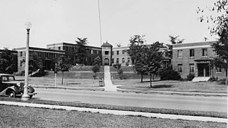
The Philadelphia Naval Hospital was the first high-rise hospital building constructed by the United States Navy. At its 1935 opening it represented a state-of-the-art facility for the Navy with 650 beds and a total floor space of 352,000 square feet (32,700 m2). The dedicated medical purpose of this facility contributed to the World War II mission as the center for amputation, orthopedic and prosthetic services for Navy, Marine, and Coast Guard veterans residing east of the Rocky Mountains.
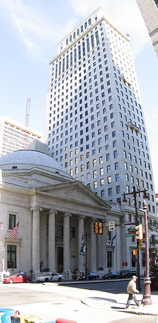
The Ritz-Carlton Philadelphia is a luxury hotel and residential complex that is located in Center City, Philadelphia, Pennsylvania, United States. It comprises three adjoining buildings: the Girard Trust Bank, at the northwest corner of South Broad and Chestnut Streets, the Girard Trust Building, at the southwest corner of South Broad Street and South Penn Square, and The Residences at the Ritz Carlton, at 1414 South Penn Square.

Naval Square is a gated community within the Graduate Hospital neighborhood of Philadelphia that served as the first United States Naval Academy from 1834 to 1845, when the Naval Academy formed in Annapolis. It continued as a retirement home for sailors and marines and was called the Naval Home until 1976, when the facility was relocated to Mississippi.

Girard Avenue is a major commercial and residential street in Philadelphia. For most of its length it runs east–west, but at Frankford Avenue it makes a 135-degree turn north. Parts of the road are signed as U.S. Route 13 and U.S. Route 30.
| | This Philadelphia-related article is a stub. You can help Wikipedia by expanding it. |