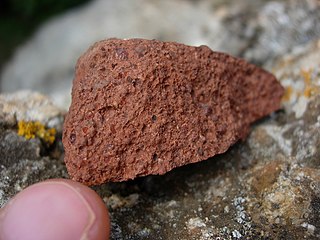
Bauxite is a sedimentary rock with a relatively high aluminium content. It is the world's main source of aluminium and gallium. Bauxite consists mostly of the aluminium minerals gibbsite, boehmite and diaspore, mixed with the two iron oxides goethite and haematite, the aluminium clay mineral kaolinite and small amounts of anatase and ilmenite . Bauxite appears dull in luster and is reddish-brown, white, or tan.

Ghana, officially the Republic of Ghana, is a country in West Africa. It lies adjacent to the Gulf of Guinea and the Atlantic Ocean to the south, sharing a border with Ivory Coast in the west, Burkina Faso in the north, and Togo in the east. Ghana covers an area of 239,567 km2 (92,497 sq mi), spanning diverse ecologies, from coastal savannas to tropical rainforests. With nearly 35 million inhabitants, Ghana is the second-most populous country in West Africa. The capital and largest city is Accra; other significant cities include Kumasi, Tamale, and Sekondi-Takoradi. In 1957 Ghana became the first colony in Sub-Saharan Africa to achieve sovereignty, under the leadership of Kwame Nkrumah.

The economy of Guinea is dependent largely on agriculture and other rural activities. Guinea is richly endowed with good minerals, possessing an estimated quarter of the world's proven reserves of bauxite, more than 1.8 billion tonnes of high-grade iron ore, significant diamond and gold deposits, and undetermined quantities of uranium. In 2021, Guinea was the world's biggest exporter of Aluminium Ore 2021 trade surplus was $4.3B.
The economy of Liberia is extremely underdeveloped, with only $3.222 billion by gross domestic product as of 2019, largely due to the First (1989–1996) and Second Liberian Civil War (1999–2003). Liberia itself is one of the poorest and least developed countries in the world, according to the United Nations.

Mining is the extraction of valuable geological materials and minerals from the surface of the Earth. Mining is required to obtain most materials that cannot be grown through agricultural processes, or feasibly created artificially in a laboratory or factory. Ores recovered by mining include metals, coal, oil shale, gemstones, limestone, chalk, dimension stone, rock salt, potash, gravel, and clay. The ore must be a rock or mineral that contains valuable constituent, can be extracted or mined and sold for profit. Mining in a wider sense includes extraction of any non-renewable resource such as petroleum, natural gas, or even water.

Ore is natural rock or sediment that contains one or more valuable minerals, typically including metals, concentrated above background levels, and that is economically viable to mine and process. The grade of ore refers to the concentration of the desired material it contains. The value of the metals or minerals a rock contains must be weighed against the cost of extraction to determine whether it is of sufficiently high grade to be worth mining and is therefore considered an ore. A complex ore is one containing more than one valuable mineral.
Iron County is a county located in the U.S. state of Wisconsin. As of the 2020 census, the population was 6,137, making it the third-least populous county in Wisconsin. Its county seat is Hurley. It was named for the valuable iron ore found within its borders. The county overlaps with small parts of the Bad River and Lac du Flambeau Indian reservations.

Waukon is a city in Makee Township, Allamakee County, Iowa, United States, and the county seat of Allamakee County. The population was 3,827 at the time of the 2020 census.

A gold rush or gold fever is a discovery of gold—sometimes accompanied by other precious metals and rare-earth minerals—that brings an onrush of miners seeking their fortune. Major gold rushes took place in the 19th century in Australia, Greece, New Zealand, Brazil, Chile, South Africa, the United States, and Canada while smaller gold rushes took place elsewhere.

The Mesabi Iron Range is a mining district and mountain range in northeastern Minnesota following an elongate trend containing large deposits of iron ore. It is the largest of four major iron ranges in the region collectively known as the Iron Range of Minnesota. First described in 1866, it is the chief iron ore mining district in the United States. The district is located largely in Itasca and Saint Louis counties. It has been extensively worked since 1892, and has seen a transition from high-grade direct shipping ores through gravity concentrates to the current industry exclusively producing iron ore (taconite) pellets. Production has been dominantly controlled by vertically integrated steelmakers since 1901, and therefore is dictated largely by US ironmaking capacity and demand.

Bambari is a town in the Central African Republic, lying on the Ouaka River. It has a population of 41,356 and is the capital of Ouaka prefecture. Bambari is an important market town and home to Bambari Airport, and the Roman Catholic Diocese of Bambari.

The Northern Region is one of the sixteen regions of Ghana. It is situated in the northern part of the country and ranks as the second largest of the sixteen regions. Before its division, it covered an area of 25,000 square kilometres, representing 10 percent of Ghana's area. In December 2018, the Savannah Region and North East Region were created from it. The Northern Region is divided into 16 districts. The region's capital is Tamale, Ghana's third largest city.
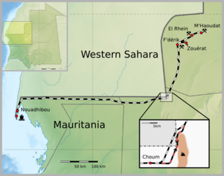
The Mauritania Railway is the national railway of Mauritania. Construction of the line began in 1960, with its opening in 1963. It consists of a single, 704-kilometre (437 mi) railway line linking the iron mining center of Zouérat with the port of Nouadhibou, via Fderik and Choum. The state agency Société nationale industrielle et minière (SNIM) controls the railway line.

Ferrous metallurgy is the metallurgy of iron and its alloys. The earliest surviving prehistoric iron artifacts, from the 4th millennium BC in Egypt, were made from meteoritic iron-nickel. It is not known when or where the smelting of iron from ores began, but by the end of the 2nd millennium BC iron was being produced from iron ores in the region from Greece to India, The use of wrought iron was known by the 1st millennium BC, and its spread defined the Iron Age. During the medieval period, smiths in Europe found a way of producing wrought iron from cast iron, in this context known as pig iron, using finery forges. All these processes required charcoal as fuel.

Mining in Ghana is a significant contributor to the nation's economy, accounting for approximately 5% of Ghana's Gross Domestic Product (GDP) and 37% of total exports. Gold dominates the mineral sector, contributing over 90% of total mineral exports. In 2019, Ghana overtook South Africa to become the largest gold producer in Africa, producing 142.4 metric tonnes of gold that year.
The West African Craton (WAC) is one of the five cratons of the Precambrian basement rock of Africa that make up the African Plate, the others being the Kalahari craton, Congo craton, Saharan Metacraton and Tanzania Craton. Cratons themselves are tectonically inactive, but can occur near active margins, with the WAC extending across 14 countries in Western Africa, coming together in the late Precambrian and early Palaeozoic eras to form the African continent. It consists of two Archean centers juxtaposed against multiple Paleoproterozoic domains made of greenstone belts, sedimentary basins, regional granitoid-tonalite-trondhjemite-granodiorite (TTG) plutons, and large shear zones. The craton is overlain by Neoproterozoic and younger sedimentary basins. The boundaries of the WAC are predominantly defined by a combination of geophysics and surface geology, with additional constraints by the geochemistry of the region. At one time, volcanic action around the rim of the craton may have contributed to a major global warming event.
Aboso is a town near Tarkwa, and is the capital of Wassa West district, a district in the Western Region of Ghana. Aboso is the 78th most populous settlement in Ghana, with a population of 9,945 people. At the Ghana census of 18 March 1984, there were 4,700 inhabitants living in the town.

The Kingdom of Dagbon is the oldest and one of the most organised traditional kingdoms in Ghana founded by the Dagomba people (Dagbamba) in the 15th century. During its rise, it comprised, at various points, the Northern, Upper West, Upper East, Savannah Region and North East regions of present-day Ghana. It also covered portions of Burkina Faso, North East Ivory Coast and North West Togo. Since Ghana's independence in 1957, the Kingdom just like all of Ghana's kingdoms and ethnic states has assumed a traditional, customary role.
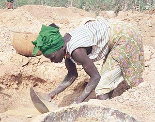
The mining industry of Guinea was developed during colonial rule. The minerals extracted consisted of iron, gold, diamond, and bauxite. Guinea ranks first in the world in bauxite reserves and 6th in the extraction of high-grade bauxite, the aluminium ore. The mining industry and exports of mining products accounted for 17% of Guinea's gross domestic product (GDP) in 2010. Mining accounts for over 50% of its exports. The country accounts for 94% of Africa's mining production of bauxite. The large mineral reserve, which has mostly remained untapped, is of immense interest for international firms.
Ghana was initially referred to as the Gold Coast. After attaining independence, the country's first sovereign government named the state after the Ghana Empire in modern Mauritania and Mali. Gold Coast was initially inhabited by different states, empires and ethnic groups before its colonization by the British Empire. The earliest known physical remains of the earliest man in Ghana were first discovered by archaeologists in a rock shelter at Kintampo during the 1960s. The remains were dated to be 5000 years old and it marked the period of transition to sedentism in Ghana. Early Ghanaians used Acheulean stone tools as hunter gatherers during the Early stone age. These stone tools evolved throughout the Middle and Late Stone Ages, during which some early Ghanaians inhabited caves.