Southernmost settlements are cities, towns, weather stations or permanent military bases which are farther south than latitude 45°S. They are closely related to the Southern Ocean or either the Roaring Forties or Furious Fifties. Antarctic bases are excluded due to not having a permanent population.
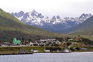
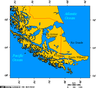
Puerto Williams is the city, port and naval base on Navarino Island in Chile. It faces the Beagle Channel. It is capital of the Chilean Antarctic Province, one of four provinces in the Magellan and Chilean Antarctica Region, and administers the communes of Chilean Antarctic Territory and Cabo de Hornos. It has a population of 2,874, including both naval personnel and civilians. Puerto Williams claims the title of world's southernmost city. The settlement was founded in 1953, and was first named Puerto Luisa. The town was later named after John Williams Wilson, a British man who founded Fuerte Bulnes, the first settlement in the Strait of Magellan since 1587. It has served primarily as a naval base for Chile. The Chilean Navy runs the Guardiamarina Zañartu Airport and hospital, as well as nearby meteorological stations. Since the late 20th century, the number of navy personnel has decreased in Puerto Williams and the civilian population has increased. In that period, tourism and support of scientific research have contributed to an increase in economic activity.

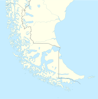
Antártica Chilena Province is the southernmost and one of four provinces in Chile's southernmost region, Magallanes and Antártica Chilena Region (XII). The capital is Puerto Williams. The province comprises the extreme southern part of Isla Grande de Tierra del Fuego, the islands south and west of Isla Grande, and Chile's claims in Antarctica. The province is administratively divided into two communes (comunas): Cabo de Hornos, located at the southern tip of South America, and Antártica, a wedge-shaped claim of Antarctica, which is not internationally recognized. Its total area of 1,265,853.7 km2 (488,749 sq mi) makes it almost twice as large as all other provinces of Chile combined.
Navarino or Navarin may refer to:

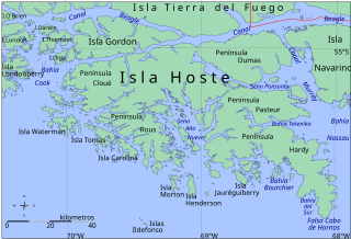
Hoste Island is one of the southernmost islands in Chile, lying south, across the Beagle Channel, from Isla Grande de Tierra del Fuego and west of Navarino Island, from which it is separated by the Murray Channel. Hoste Island has the southernmost trees on earth, Nothofagus antarctica. In Magellania, Jules Verne described an imaginary republic on the island.

Picton, Lennox and Nueva form a group of three islands at the extreme southern tip of South America, in the Chilean commune of Cabo de Hornos in Antártica Chilena Province, Magallanes and Antártica Chilena Region. Located in the Tierra del Fuego archipelago, they lie east of Navarino Island and are separated from the Argentine part of Isla Grande in the north by the Beagle Channel. They have an area of 170.4 km2 (Lennox), 105.4 km2 (Picton), 120.0 km2 (Nueva).

Puerto Toro is a hamlet on the eastern coast of Navarino Island, Chile. Puerto Toro was founded in 1892 during the Tierra del Fuego Gold Rush by Governor of Punta Arenas Señoret.

A commune is the smallest administrative subdivision in Chile. It may contain cities, towns, villages, hamlets as well as rural areas. In highly populated areas, such as Santiago, Valparaíso and Concepción, a conurbation may be broken into several communes. In sparsely populated areas, conversely, a commune may cover a substantial rural area together with several settled areas which could range from hamlets to towns or cities.
Peninsula Hardy is a peninsula at one of the most southerly extremes of South America. It is the southern landform which extends into the Drake Passage to make the Bahia Nassau. It is part of a large island called Hoste, next to Isla Navarino and Isla Grande de Tierra del Fuego. It is located in the Commune of Cabo de Hornos, belonging to the Antártica Chilena Province of the Magallanes y Antártica Chilena Region, Chile. False Cape Horn is located at the southern tip of this peninsula.

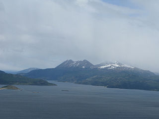
Navarino Island is a Chilean island located between Isla Grande de Tierra del Fuego, to the north, and Cape Horn, to the south. The island forms part of the Commune of Cabo de Hornos, the southernmost commune in Chile and in the world, belonging to Antártica Chilena Province in the XII Region of Magallanes and Chilean Antarctica. Its population is concentrated primarily in the communal capital, Puerto Williams, and in small settlements like Puerto Navarino, Río Guanaco and Puerto Toro. The highest point of the island is Pico Navarino at 1,195 m (3,921 ft). The island is a popular destination for fly-fishers.

Cabo de Hornos National Park is a protected area in southern Chile that was designated a Biosphere Reserve by UNESCO in 2005, along with Alberto de Agostini National Park. The world's southernmost national park, it is located 12 hours by boat from Puerto Williams in the Cape Horn Archipelago, which belongs to the Commune of Cabo de Hornos in the Antártica Chilena Province of Magallanes y Antártica Chilena Region.
The Murray Channel is a channel of Chile located in the Commune of Cabo de Hornos, in the Antártica Chilena Province of the Magallanes y la Antártica Chilena Region. It separates Hoste Island from Navarino Island and is bounded by the Beagle Channel to the north. The salinity of the Murray Channel is approximately 31.8 parts per thousand.
The Wollaston Islands are a group of islands in Chile south of Navarino Island and north of Cape Horn and east of the Hoste Island. The islands are Grevy, Bayly, Wollaston and Freycinet, as well as the islets Dédalo, Surgidero, Diana, Otarie, Middle and Adriana. The islands are part of Cabo de Hornos National Park.
Omora Ethnobotanical Park is a protected area of Chile located 4 km (2 mi) west of Puerto Williams on Navarino Island in the extreme southern Magellan and Chilean Antarctica Region. The Omora Park is a research, education and conservation center for the Cape Horn Biosphere Reserve. The park itself includes a representative variety subantarctic flora open to the public for formal and information education. Within its boundaries, one can find deciduous forests and evergreen broadleaf forests, as well as bogs and high-Andean ecosystems and diverse mosses, lichens and liverworts.
Cabo de Hornos is a Chilean commune located in the south of Tierra del Fuego archipelago, in Antártica Province, Magallanes Region. The municipality of Cabo de Hornos, located in the town of Puerto Williams, also administers the Antártica commune. It is named for Cabo de Hornos, or "Cape Horn", the southern tip of South America.
Río Guanaco is a hamlet on Navarino Island in the Tierra del Fuego archipelago in southern Chile. It is part of the Cabo de Hornos commune in Antártica Chilena Province.

Bahia Wulaia is a bay on the western shore of Isla Navarino along the Murray Channel in extreme southern Chile. The island and adjacent strait are part of the commune of Cabo de Hornos in the Antártica Chilena Province, which is part of the Magallanes and Antartica Chilena Region.
The Sistema Eléctrico de Magallanes or SEM is an alternating current power grid serving the Magallanes and Antartica Chilena Region of Chile. All of the SEM's power generation is produced by combustion of fossil fuels in thermal power plants, some of the fuel comes from the oilfields in the Strait of Magellan. SEM's power generation stands currently for about 0.8% of the national generation. The communes of Antártica and Cabo de Hornos, including Puerto Williams are not connected to the system.

The Micalvi was an auxiliary vessel of the Chilean Navy.

Antártica is a Chilean commune in Antártica Chilena Province, Magallanes y la Antártica Chilena Region, which covers all the Chilean Antarctic Territory. It ranges from 53°W to 90°W and from the South Pole to 60°S, overlapping the Argentine and British Antarctic claims, and is the largest and least populated commune in Chile, being over 25 times the size of the next largest commune, Natales. It is administered by the Cabo de Hornos municipality in the South American mainland.