
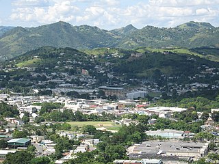
Caguas is a city and municipality of Puerto Rico located in the Central Mountain Range of Puerto Rico, south of San Juan and Trujillo Alto, west of Gurabo and San Lorenzo, and east of Aguas Buenas, Cidra, and Cayey. Caguas was founded in 1775. The municipality had a population of 127,244 at the 2020 census.
Cayey, officially Cayey de Muesas, is a mountain town and municipality in central Puerto Rico located on the Sierra de Cayey within the Central Mountain range, north of Salinas and Guayama; south of Cidra and Caguas; east of Aibonito and Salinas; and west of San Lorenzo. Cayey is spread over 21 barrios plus Cayey Pueblo. It is part of the San Juan-Caguas-Guaynabo Metropolitan Statistical Area.
Cidra is a town and municipality of Puerto Rico located in the central region of the island, north of Cayey; south of Comerío and Aguas Buenas; east of Aibonito and Barranquitas; and west of Caguas. Cidra is spread over 12 barrios and Cidra Pueblo. It is part of the San Juan-Caguas-Guaynabo Metropolitan Statistical Area.
Puerto Rico Highway 52 (PR-52), a major toll road in Puerto Rico, is also known as Autopista Luis A. Ferré. It was formerly called Expreso Las Américas. It runs from PR-1 in southwest Río Piedras and heads south until it intersects with highway PR-2 in Ponce. At its north end, the short PR-18 continues north from PR-52 towards San Juan. This short segment is known as Expreso Las Américas, the only segment of the route still unofficially bearing this name, since PR-18 is officially named Roberto Sánchez Vilella Expressway. The combined route of PR-18 and PR-52 runs concurrent with the unsigned Interstate Highway PRI-1. Toll stations are located in San Juan, Caguas, Salinas, Juana Díaz, and Ponce.

The Monumento al Jíbaro Puertorriqueño is a monument built by the Government of Puerto Rico to honor the Puerto Rican Jíbaro, located on Puerto Rico Highway 52, km 49.0, Barrio Lapa, Salinas, Puerto Rico. It was sculpted by Tomás Batista.
Puerto Rico Highway 1 (PR-1) is a highway in Puerto Rico that connects the city of Ponce to San Juan. Leaving Ponce, the road heads east and follows a somewhat parallel route along the southern coast of the island heading towards Salinas. At Salinas, the road turns north to cut through the Cordillera Central in its approach to San Juan. Before reaching San Juan, it climbs to make its way to the mountain town of Cayey and then it winds down into the city of Caguas on its final approach to San Juan.
Puerto Rico Highway 53 (PR-53) or unsigned Interstate PR3 is a main tollway that is parallel to Puerto Rico Highway 3, which goes from Fajardo to Salinas. Some segments are still in planning, but when finished it will be about 58 miles (93 km) in length. Two tunnels, about 0.6 mi (1 km) long each, in the towns of Yabucoa and Maunabo were completed in October 2008. It will connect the cities of Fajardo, Ceiba, Naguabo, Humacao, Yabucoa, Maunabo, Patillas, Arroyo, Guayama and Salinas, thus bordering the entire eastern and southeastern coasts of Puerto Rico. Its northern terminus is at PR-3 and PR-194 in Fajardo, and its south terminus is at PR-52 in Salinas.

Puerto Rico Highway 14 (PR-14) is a main highway connecting Ponce to Cayey, Puerto Rico. The road runs the same course as the historic Carretera Central. The Ponce-to-Coamo section of PR-14 was built under the direction of Spanish engineer Raimundo Camprubí Escudero.

Puerto Rico Highway 15 (PR-15), formerly Road No. 4, is a main highway connecting the municipalities of Guayama and Cayey in Puerto Rico. With a length of 25.80 km (16.03 mi), it extends from PR-3 in downtown Guayama to PR-14 in downtown Cayey.

Puerto Rico Highway 172 (PR-172) is a secondary highway that connects Caguas, Puerto Rico at PR-1 to downtown Cidra, Puerto Rico and continues its way to its end at Puerto Rico Road 156 in Comerío, Puerto Rico. It is a two-lane per direction road from Caguas to its border point to Cidra and rural all the way to Comerío.

Puerto Rico Highway 184 (PR-184) is a main, rural highway that connects Patillas to Cayey, Puerto Rico, with plans to be extended to Cidra. It extends from PR-3 in Cacao Bajo to PR-1 in Beatriz.

Puerto Rico Highway 206 (PR-206) is a connector in Cayey, Puerto Rico that bypasses the downtown area of Cayey, making easier for drivers who do not want to access the congested area of the business center to directly go from Puerto Rico Highway 1 to Puerto Rico Highway 14 to Aibonito, Puerto Rico. Like Puerto Rico Highway 203 and future Puerto Rico Highway 204, PR-206 has two lanes per direction and is about 1.8 km long.
The Carretera Central is a historic north–south central highway in Puerto Rico, linking the cities of San Juan and Ponce by way of Río Piedras, Caguas, Cayey, Aibonito, Coamo, and Juana Díaz. It crosses the Cordillera Central. Plans for the road started in the first half of the 19th century, and the road was fully completed in 1898. At the time the United States took possession of Puerto Rico in 1898, the Americans called it "the finest road in the Western Hemisphere."

Puerto Rico Highway 9 (PR-9), also called the Anillo de Circunvalación de Ponce, is a limited-access state highway located entirely within the limits of the municipality of Ponce, Puerto Rico, and connecting Puerto Rico Highway 10 in Barrio Portugués in the north to Puerto Rico Highway 52 in barrio Canas in the south, crossing Barrio Magueyes. The Oficina de Ordenación Territorial of the Autonomous Municipality of Ponce calls this road Ronda de Circunvalación Román Baldorioty de Castro. The roadway is still under construction.

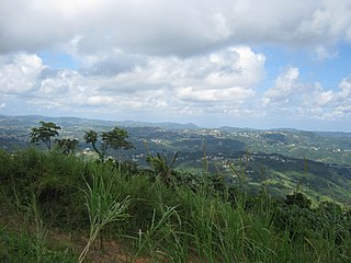
Porta Cordillera, or simply Central Region, is a land-locked tourism region located in the central mountainous area of Puerto Rico. Porta Cordillera was officially launched in July 2012 by the Puerto Rico Tourism Company. It consists of 16 municipalities: Aguas Buenas, Cidra, Cayey, Comerío, Aibonito, Naranjito, Barranquitas, Corozal, Orocovis, Morovis, Ciales, Jayuya, Florida, Utuado, Adjuntas and Lares.

Puerto Rico Highway 735 (PR-735) is a rural road located between the municipalities of Cayey and Cidra, Puerto Rico, and it corresponds to an original segment of the historic Carretera Central. The Arenas and La Liendre old bridges are located on this route.

Puerto Rico Highway 171 (PR-171) is a road that travels from Cidra, Puerto Rico to Cayey. It begins at its intersection with PR-172 in downtown Cidra and ends at its junction with PR-14 near downtown Cayey.

Puerto Rico Highway 170 (PR-170) is a road located in Cayey, Puerto Rico. This highway begins at its intersection with PR-14 and PR-731 in downtown Cayey and ends at its junction with PR-1 and PR-206 in Matón Arriba.
The Roads in Puerto Rico are the national, forest and municipal roadways that make up the approximately 14,400 kilometers (8,900 mi) roads through the terrain of Puerto Rico. The highways serve the more than 3 million residents, and 3-4 million tourists who visit each year.
