 Highway 54 | ||||
|---|---|---|---|---|
| Ruta 54 | ||||
| Avenida Pedro Albizu Campos | ||||
 PR-54 highlighted in red | ||||
| Route information | ||||
| Maintained by Puerto Rico DTPW | ||||
| Length | 6.20 km [1] (3.85 mi) | |||
| Major junctions | ||||
| West end | ||||
| ||||
| East end | ||||
| Location | ||||
| Country | United States | |||
| Territory | Puerto Rico | |||
| Municipalities | Guayama | |||
| Highway system | ||||
| ||||
Puerto Rico Highway 54 (PR-54) is a short divided highway located in Guayama, Puerto Rico and is mainly a by-pass route from Puerto Rico Highway 3 out of Downtown Guayama to Puerto Rico Highway 53. The government of Puerto Rico named the stretch of highway that extends from PR-54, in Guayama, to PR-52, in Salinas Autopista José M. Dávila Monsanto in honor of the late Puerto Rican political leader José M. Dávila Monsanto. [2]
Contents
 PR-54 allows people to access PR-3 from PR-53 without having to enter downtown Guayama
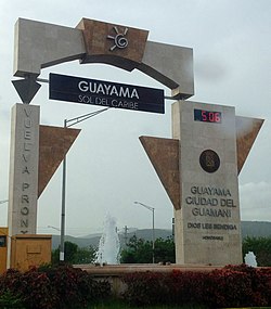 Guayama welcome sign from Highway 54


