The Central System, Spanish and Portuguese: Sistema Central, is one of the main systems of mountain ranges in the Iberian Peninsula. The 2,592 m high Pico Almanzor is its highest summit.

The Sierra de Guadarrama is a mountain range forming the main eastern section of the Sistema Central, the system of mountain ranges along the centre of the Iberian Peninsula. It is located between the systems Sierra de Gredos in the province of Ávila, and Sierra de Ayllón in the province of Guadalajara.
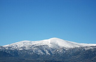
Peñalara is the highest mountain peak in the mountain range of Guadarrama, a subsection of Spain's larger Sistema Central mountain chain which lies at the center and divides the Iberian Peninsula. Straddling the provinces of Madrid and Segovia, Peñalara reaches a height of 2,428 metres above sea level. Consequently, it is one of the most emblematic and important peaks of the Guadarramas.

Valdesquí is a ski area situated near the town of Rascafría in the Sierra de Guadarrama near Madrid (Spain). The area is close to the Navacerrada resort (Madrid), and projects have been attempted to link the two areas, stopped by ecologist movements.

The Peñalara Natural Park is a natural park of 7.68 km2 in the northwest of the Community of Madrid, Spain. It was designated in June 1990. The park is situated in the central zone of the Sierra de Guadarrama. Since 2013, the Sierra de Guadarrama has also been protected by a national park designation.
Sierra de Guadarrama National Park is a national park in Spain, covering nearly 34,000 hectares, the fifth largest in Spain's national parks system. The Guadarrama mountain range contains some ecologically valuable areas, located in the Community of Madrid and Castile and León. The law that regulates the recently approved national park was published in the BOE in June 26, 2013.
The Maratón Alpino Madrileño or Madrid Alpine Marathon is a trail running race that takes place on Sierra de Guadarrama, in Madrid (Spain), in mid-June. This race covers nearly 45 kilometres (28 mi) with 4,700 metres (15,400 ft) of altitude change. Since 2006, the start and the end points of the race are located in Cercedilla, and its course goes through Alto del Telégrafo, Puerto de Navacerrada, Bola del Mundo, Puerto de Cotos, Pico Peñalara and the glacial Peñalara lakes. The Tierra Trágame club is in charge of organizing this race.

Dodge Ridge Wintersports Area is a ski area near Pinecrest, California in Tuolumne County, off of Highway 108, 30 mi (48 km) east of Sonora. The resort is located in the Stanislaus National Forest and operates under a special use permit. Many skiers in Northern California use Dodge Ridge because of its proximity to the San Francisco Bay Area, San Joaquin Valley and Yosemite National Park. The winter sports season typically lasts from late November through mid April. The mountain summit sits at 8,200' above sea level. Dodge Ridge was founded by various individuals, and managed by the Purdy family, in 1950, and then owned by the Helm family from 1976 up until the 2021-2022 season, when it was acquired by Invision Capital and Karl Kapusciniski. Dodge Ridge is a member of Powder Alliance, which offers reciprocal ski passes to season pass holders of various resorts. Beginning in the 2021/2022 season Dodge Ridge began to experiment with "light snowmaking at the base."
Becerril de la Sierra is a municipality of the autonomous community of Madrid in central Spain.

Cercedilla is a municipality in the Community of Madrid, in central Spain. It is located in the Sierra de Guadarrama.

Navacerrada is a municipality of the Community of Madrid, Spain. It lies at an elevation of 1,203 metres (3,947 ft) on the Reservoir Navacerrada and the entry of "Valle de la Barranca" in the Sierra de Guadarrama.

Oteruelo del Valle is a Spanish town of the province and community of Madrid, situated in the valley of Lozoya, exactly in the northwest of the province. The nearest villages are Alameda del Valle (1.4 km), Rascafría (2.3 km) and Pinilla del Valle (2.8 km). It was an independent township until 1975, but since then it is part of Rascafría, being considered as one of the nucleus of the population.

Line C-9, formerly known as the Guadarrama Electric Railway, is a narrow-gauge mountain railway incorporated into Madrid's Cercanías commuter rail network. The line is operated by Renfe Operadora and runs through the Guadarrama Mountains from Cercedilla, Madrid to Cotos Pass, Segovia. Although classified as a commuter rail line, Line C-9 primarily serves the ski resorts at Cotos and Navacerrada Passes, connecting with the rest of the commuter rail system with the Line C-8 at Cercedilla Station. Line C-9 is the only metre-gauge railway among the Cercanías Madrid lines.
The Navacerrada Pass is a mountain pass in the Guadarrama Mountains, in the centre of the Iberian Peninsula.

La Maliciosa is one of the most important and highest mountains of the Sierra de Guadarrama, a mountainous formation belonging to the Sistema Central. It has an altitude of 2227m above sea level and is located in the northwest of the Community of Madrid, in Spain, rising between La Pedriza, which lies to the east, and La Barranca valley, which is on its western slope.

The Cuenca Alta del Manzanares Regional Park, created in 1985, is the natural space protected area with the largest extension in the Community of Madrid (Spain) and one of the most ecologically and scenically valuable. It is located in the northwest of the region and extends around the upper course of the Manzanares River, along 42 583 ha. Its main municipalities of reference are Manzanares el Real and Hoyo de Manzanares. Unesco declared it a Biosphere Reserve in 1992.

Valsain Valley is a valley of the northern slope of the Guadarrama mountain range. It is located in the southeastern part of the province of Segovia, within the municipality of Real Sitio de San Ildefonso, and borders the Community of Madrid. The valley is covered by an extensive pine forest known as el Pinar, the largest in the mountains and one of the best preserved in Spain.

The Valsain Mountains are located in the Valsain Valley, on the northern slope of the Sierra de Guadarrama and in the municipality of Real Sitio de San Ildefonso, belonging to the province of Segovia.

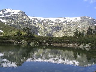
Peñalara glacial cirque, is a cirque glacier located within the Peñalara Natural Park, in the center of the Sierra de Guadarrama. It is the most extensive of the mountain range with its 140 hectares approximately. Administratively it is within the municipality of Rascafría, a Spanish municipality located in the northwest of the Community of Madrid.

Bola del Mundo or Alto de las Guarramillas is a mountain in the Sierra de Guadarrama, in the Sistema Central of the Iberian Peninsula. It is located in the Community of Madrid, near the border with the province of Segovia, in Spain. It has an altitude of 2257 meters with a prominence of 103 meters, and is the westernmost summit of the Cuerda Larga mountain range. Very close to the summit, on the east side, is the Ventisquero de la Condesa, an area with water emanations that constitutes the source of the Manzanares river, and where great thicknesses of snow accumulate in winter.


