Sistema Central

Last updated
Central System
Sistema Central
LA SERROTA.JPG
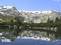
View of La Serrota, 2.294 m, in Ávila Province
Highest point
Peak Pico Almanzor
Elevation 2,592 m (8,504 ft)
Coordinates 40°14′48″N05°17′52″W / 40.24667°N 5.29778°W / 40.24667; -5.29778
Dimensions
Length600 km (370 mi)ENE - WSW
Width30 km (19 mi)NNW - SSE
Geography
Sistema Central.png
Location of the Sistema Central in the Iberian Peninsula
Countries Spain and Portugal
Communities Extremadura, Castile-La Mancha and Castile and León
Districts Guarda and Castelo Branco
Geology
Orogeny Alpine
Age of rock Tertiary
Type of rock Limestone and sandstone

The Central System, Spanish and Portuguese : Sistema Central, is one of the main systems of mountain ranges in the Iberian Peninsula. The 2,592 m high Pico Almanzor is its highest summit.

Contents

The Central System is located just north of the 40th parallel and its ranges divide the drainage basin of the Tagus from the basin of the Douro.

Description

The Sistema Central is a primary feature of the Meseta Central, the inner Iberian plateau, splitting the meseta into two parts. The Sistema Central runs in an ENE - WSW direction roughly along the southern border of the Spanish autonomous community of Castile and León and Extremadura continuing into the Guarda and Castelo Branco districts in Portugal.

Unlike the neighboring Sistema Ibérico, the Sistema Central range is a quite homogeneous system. It consists of several ranges that formed 25 million years ago as part of the Alpine orogeny.

The major mountain ranges are the Sierra de Guadarrama, which runs approximately along the border of the Madrid and Castile and León autonomous communities, the Sierra de Gredos north of the border between Castile and León and Castile-La Mancha stretching into Extremadura and containing the range's highest mountain, Pico Almanzor, at 2,592 m, as well as the Serra da Estrela, containing the highest point in continental Portugal, A Torre, 1,993 m. Other notably large ranges are Sierra de Gata and Sierra de Ayllón. The Central System links with the Sistema Ibérico at its eastern end through the Sierra de Pela, the Altos de Barahona and Sierra Ministra, the latter already fully part of the Iberian System. [1]

"Sistema Central" is a widely known academic geographical term. Local inhabitants, however, generally refer to the Sistema Central by the names of its smaller constituent ranges.

Mountain ranges

The main ranges of the Sistema Central from west to east followed by their highest points are:

Main ranges and features

See also

Related Research Articles

<span class="mw-page-title-main">Geography of Spain</span> Overview of the geography of Spain

Spain is a country located in southwestern Europe occupying most of the Iberian Peninsula. It also includes a small exclave inside France called Llívia, as well as the Balearic Islands in the Mediterranean, the Canary Islands in the Atlantic Ocean 108 km (67 mi) off northwest Africa, and five places of sovereignty on and off the coast of North Africa: Ceuta, Melilla, Islas Chafarinas, Peñón de Alhucemas, and Peñón de Vélez de la Gomera.

<span class="mw-page-title-main">Sierra de Gata</span>

Sierra de Gata is one of the main mountain ranges in the Sistema Central, Spain. The highest point is Peña Canchera.

<span class="mw-page-title-main">Baetic System</span>

The Baetic System or Betic System is one of the main systems of mountain ranges in Spain. Located in the southern and eastern Iberian Peninsula, it is also known as the Cordilleras Béticas or Baetic Mountains. The name of the mountain system derives from the ancient Roman region of Baetica, one of the Imperial Roman provinces of ancient Hispania.

<span class="mw-page-title-main">Sierra Morena</span> Mountain range in southern Spain

The Sierra Morena is one of the main systems of mountain ranges in Spain. It stretches for 450 kilometres from east to west across the south of the Iberian Peninsula, forming the southern border of the Meseta Central plateau and providing the watershed between the valleys of the Guadiana to the north and the west, and the Guadalquivir to the south.

Peña, meaning "rocky outcrop" or "rocky summit" in the Spanish language. It may refer to:

<span class="mw-page-title-main">Cantabrian Mountains</span> Mountain range in Spain

The Cantabrian Mountains or Cantabrian Range are one of the main systems of mountain ranges in Spain. They stretch for over 300 km (180 miles) across northern Spain, from the western limit of the Pyrenees to the Galician Massif in Galicia, along the coast of the Cantabrian Sea. Their easternmost end meets the Sistema Ibérico.

<span class="mw-page-title-main">Sierra de Gredos</span> Mountain range

The Sierra de Gredos is a mountain range in central Spain that spans the provinces of Ávila, Salamanca, Cáceres, Madrid, and Toledo. It is part of the much larger Sistema Central of mountain ranges. Its highest point is Pico Almanzor, at 2,592 meters and it has been declared a natural park by the Autonomous Community of Castile and León. The Sierra de Gredos is one of the most extensive mountain ranges of the Central System; it comprises five river valleys: the Alto Tormes, the Alto Alberche, the Tiétar Oriental, the Tiétar Occidental y la Vera, and the Valle del Ambroz. The first known inhabitants were the Vettones, a pre-Roman Celtic people. The central part of the range encomprises the Sierra de Gredos Regional Park.

<span class="mw-page-title-main">Sierra de Guadarrama</span> Mountain range in Spain

The Sierra de Guadarrama is a mountain range forming the main eastern section of the Sistema Central, the system of mountain ranges along the centre of the Iberian Peninsula. It is located between the systems Sierra de Gredos in the province of Ávila, and Sierra de Ayllón in the province of Guadalajara.

<span class="mw-page-title-main">Peñalara</span> Mountain in Spain

Peñalara is the highest mountain peak in the mountain range of Guadarrama, a subsection of Spain's larger Sistema Central mountain chain which lies at the center and divides the Iberian Peninsula. Straddling the provinces of Madrid and Segovia, Peñalara reaches a height of 2,428 metres above sea level. Consequently, it is one of the most emblematic and important peaks of the Guadarramas.

<span class="mw-page-title-main">Guadarrama National Park</span>

Sierra de Guadarrama National Park is a national park in Spain, covering nearly 34,000 hectares, the fifth largest in Spain's national parks system. The Guadarrama mountain range contains some ecologically valuable areas, located in the Community of Madrid and Castile and León. The law that regulates the recently approved national park was published in the BOE in June 26, 2013.

<span class="mw-page-title-main">Sistema Ibérico</span> Major system of mountain ranges in Spain

The Iberian System is one of the major systems of mountain ranges in Spain. It consists of a vast and complex area of mostly relatively high and rugged mountain chains and massifs located in the central region of the Iberian Peninsula, but reaching almost the Mediterranean coast in the Valencian Community in the east.

<span class="mw-page-title-main">Moncayo Range</span>

Moncayo is a 15 km long and about 7 km wide mountain chain giving name to the Tarazona y el Moncayo comarca, Aragon, Spain. The Moncayo's highest summit, San Miguel, is the highest point in the 500 km long Sistema Ibérico.

<span class="mw-page-title-main">Montes de Toledo</span>

The Montes de Toledo are one of the main systems of mountain ranges in the Iberian Peninsula. They divide the drainage basin of the Tagus from the basin of the Guadiana. The highest peak is 1,603 m (5,259 ft) high La Villuerca.

<span class="mw-page-title-main">Picos de Urbión</span>

Picos de Urbión, or "Urbion Peaks" is a mountain range in the Sistema Ibérico, Spain, limited by the Sierra de Neila and Sierra Cebollera of the same range. The ridge's highest summit, Pico Urbión, is 2,228 m) is one of the highest points in the 500 km long Sistema Ibérico.

<span class="mw-page-title-main">Sierra Menera</span>

Sierra Menera is a 31 km (19 mi) long mountain range in the southwestern end of the Iberian System.

<span class="mw-page-title-main">Jálama</span>

The Jálama is a 1,487-metre (4,879 ft) mountain in western Spain.

<span class="mw-page-title-main">Eresma River</span> River in Castile and León, Spain

The Eresma is a river in central Spain. It flows through Castile and Leon. It has a total length of 134 km and drains a basin with an area of 2940 km2.

<span class="mw-page-title-main">La Maliciosa</span> Mountain in Spain

La Maliciosa is one of the most important and highest mountains of the Sierra de Guadarrama, a mountainous formation belonging to the Sistema Central. It has an altitude of 2227m above sea level and is located in the northwest of the Community of Madrid, in Spain, rising between La Pedriza, which lies to the east, and La Barranca valley, which is on its western slope.

<span class="mw-page-title-main">Sierra de Ayllón</span> Mountain chain of the Iberian Peninsula

The Sierra de Ayllón or Macizo de Ayllón is a mountain chain of the Iberian Peninsula, belonging to the Sistema Central, of which it constitutes one of its easternmost spurs. It is located between the Spanish provinces of Guadalajara, Segovia and Madrid. The mountain chain consists of a natural area protected within the Natura 2000 network as a Site of Community Importance and Special Protection Area for Birds, located in the northwest of the province of Guadalajara in the autonomous community of Castilla-La Mancha. The natural area of Ayllón occupies the Paleozoic massif of the Sierra de Ayllón, in the province of Guadalajara, including the main core whose highest peak is the Pico del Lobo, and the Sierras de la Concha, Pico Ocejón and Alto Rey.

<span class="mw-page-title-main">Topographical relief of Spain</span>

The topographical relief of Spain is characterized by being quite high, with an average altitude of 660 meters above sea level, quite mountainous compared to other European countries and only surpassed by Switzerland, Austria, Greece and the microstates of Andorra and Liechtenstein. In peninsular Spain, the terrain is articulated around a large Meseta Central that occupies most of the center of the Iberian Peninsula. Outside the plateau, there is the depression of the Guadalquivir river, located in the southwest of the peninsula, and the Ebro river depression, located in the northeast.

References