
Charlotte Pass is a snow resort and village in the Snowy Mountains of New South Wales, Australia. The pass is in the Kosciuszko National Park where the Kosciuszko Road crosses Kangaroo Ridge. Charlotte Pass is the closest village to Mount Kosciuszko, the tallest mountain in Australia.

Mount Baw Baw is a mountain summit on the Baw-Baw Plateau of the Great Dividing Range, located in Gippsland, Victoria, Australia. The name is from the Yarra-Yallou, Gunna-Kurnai people of Gippsland. It is of uncertain meaning, but possibly signifies, echo, or ghost.

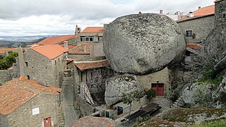
Covilhã is a city and a municipality in the Centro region, Portugal. The city proper had 33,691 inhabitants in 2021. The municipality population in 2021 was 46,455 in an area of 555.60 square kilometres (214.52 sq mi). It is located in the Beiras e Serra da Estrela subregion and Beiras and Serra da Estrela Intermunicipal Community. The municipal holiday is October 20. Sometimes referred to as town of wool and snow, Covilhã is one of the main urban centres of the historical Beira Interior region. The proximity of the mountains offers dramatic scenery and a great environment for those fond of hiking, camping, mountain climbing and skiing. With an industrial tradition historically focused on textile industry supplied by an abundance of wool produced in the area since antiquity, but with a more diversified industry in contemporaneity, Covilhã, which was once known as the "Portuguese Manchester", is also a university city nowadays awarding degrees from aeronautical engineering to medicine to philosophy.
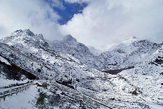
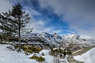
Serra da Estrela is the highest mountain range in Continental Portugal. Together with the Serra da Lousã it is the westernmost constituent range of the Sistema Central and also one of the highest in the system. It includes mainland Portugal's highest point at 1,993 metres above mean sea level. This point is not a distinctive mountain summit, but rather the highest point in a plateau, being known as Torre. Torre is an unusual summit in that it is accessible by a paved road. The peak has a topographic prominence of 1,204 m (3,950 ft) and its parent peak is Pico Almanzor, in Spain.

The Rio Mondego or Mondego River is the longest river entirely within Portuguese territory. It has its source in Serra da Estrela, the highest mountain range in mainland Portugal. It runs 234 kilometres (145 mi) from the Gouveia municipality, at 1,425 metres (4,675 ft) above sea level in Serra da Estrela, to its mouth in the Atlantic Ocean next to the city of Figueira da Foz.

Loriga is a civil parish and town in south-central part of the municipality of Seia, in central Portugal. Part of the district of Guarda, it is 20 km away from the city of Seia, 40 km away from Viseu, 80 km away from Guarda and 320 km from Lisbon, nestled in the Serra da Estrela mountain range. The population in 2011 was 1,053, in an area of 36.25 km2, including the two localities, the town of Loriga and the village of Fontão.
The Central Region or Central Portugal is one of the statistical regions of Portugal. The cities with major administrative status inside this region are Coimbra, Aveiro, Viseu, Leiria, Castelo Branco and Guarda. It is one of the seven Regions of Portugal. It is also one of the regions of Europe, as given by the European Union for statistical and geographical purposes. Its area totals 28,462 km2 (10,989 sq mi). As of 2011, its population totalled 2,327,026 inhabitants, with a population density of 82 inhabitants per square kilometre.

Seia is a municipality in Guarda District in Portugal. The population in 2021 was 21,755, in an area of 453.69 square kilometres (175.17 sq mi). Its urban population is about 7,000. Seia was elevated to city status on 3 July 1986. The municipality is situated on the northwestern slope of Serra da Estrela, the highest mountain range in mainland Portugal, with a top height of 1993 meters. The present Mayor is António Luciano Silva Ribeiro, elected by the Socialist Party. The municipal holiday is July 3. Seia has an annual cinema festival called CineEco that focuses on films with ecological and natural themes.

The Zêzere is a river in Portugal, tributary to the Tagus. It rises in the Serra da Estrela, near the Torre, the highest point of continental Portugal. The Zêzere runs through the town Manteigas, runs through Belmonte, passes south of the city of Covilhã and east of the town of Pedrogão Grande. It flows into the Tagus in Constância. It is the second longest river entirely within Portuguese territory. Its slope allows for the hydroelectric powerplants of Cabril, Bouçã and Castelo de Bode.

Manteigas is a town and a municipality in Portugal. The population in 2011 was 3,430, in an area of 121.98 square kilometres (47.10 sq mi).
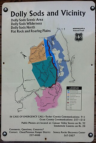
Mount Porte Crayon is a mountain in the Roaring Plains Wilderness of the Monongahela National Forest in the northeastern corner of Randolph County, West Virginia, USA. It rises to an elevation of 4,770 feet (1,450 m), the elevational climax of the Allegheny Front. The mountain is named for 19th century writer and illustrator David Hunter Strother (1816–88), known as "Porte Crayon", who produced a wide array of early West Virginia landscapes in his work.

Sporting Clube da Covilhã, commonly known as just Sporting da Covilhã or Sp. Covilhã, is a Portuguese football club from the city of Covilhã that plays in the third-tier Liga 3. The club was founded on 2 June 1923 and became the branch number 8 of Sporting Clube de Portugal. Their nickname is the Leões da Serra, meaning "Lions of the Mountain Range," due to Covilhã's location in the Serra de Estrela, the highest mountains in Portugal.
The Central System, Spanish and Portuguese: Sistema Central, is one of the main systems of mountain ranges in the Iberian Peninsula. The 2,592 m high Pico Almanzor is its highest summit.
Serra da Estrela Natural Park or Parque Natural da Serra da Estrela is a nature reserve in the largest mountain range in Portugal - the Serra da Estrela – and is the source of the rivers Mondego, Zêzere, and Alva. The park is the largest natural conservation area in Portugal and occupies about 1,000 km2. More than half of its area is located above an altitude of 700 m. At 1,993 m it contains the highest peak in Continental Portugal and a ski resort.

Serra da Estrela is a former NUTS3 statistical subregion of Portugal integrated in the NUTS2 Centro region that takes its name from the largest mountain range in Portugal - the Serra da Estrela. It was abolished at the January 2015 NUTS 3 revision.

Penhas da Saúde is a village in the municipality of Covilhã, Portugal. This mountain village sits right in the heart of Serra da Estrela, nestled within the scenic mountain range, at an altitude of 1,500 metres. It is primarily a winter resort.

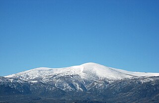
Mount Rose is the highest mountain in Washoe County, within the Carson Range of Nevada, United States. It ranks thirty-seventh among the most topographically prominent peaks in the state. It is also both the highest and most topographically prominent peak of the greater Sierra Nevada range within the state of Nevada, and the third most topographically prominent peak in the Sierra Nevada overall. It is located in the Mount Rose Wilderness of the Humboldt-Toiyabe National Forest. An extinct volcano, the mountain is in between Lake Tahoe and Reno. State Route 431 traverses Mount Rose Summit southeast of Mount Rose. Due to the high elevation, most of the precipitation that falls on the mountain is snow. The view from Mount Rose facing east is the Truckee Meadows, the second largest population center in Nevada.

Serra da Estrela Ski Resort is a ski resort located in a mountain range named Serra da Estrela, in the municipality of Seia, parish (freguesia) of Loriga, Portugal.

Mount Rose Summit is a mountain pass located in the Carson Range near Mount Rose and Slide Mountain, northeast of Incline Village, Nevada, United States. The 8,911-foot-high (2,716 m) pass is traversed by State Route 431, which is the highest point of the highway and the highest mountain pass in the Sierra Nevada that remains open year-round. The saddle itself features a parking lot and a small building which both serve as a highway stop. A closed dirt road leading to the Mount Rose Ski Resort ends near the northern section of the summit. The pass is the low point of the saddle between Slide Mountain and Tamarack Peak.

Serra de São Mamede is a mountain range in Portalegre District, Portugal. This range is named after Saint Mammes. Together with the Serra de Arraiolos, the Serra de São Mamede is one of the few places in the Alentejo region where there might be snow in the winter.


