
Cantabria is an autonomous community and province in northern Spain with Santander as its capital city. It is called a comunidad histórica, a historic community, in its current Statute of Autonomy. It is bordered on the east by the Basque autonomous community, on the south by Castile and León, on the west by the Principality of Asturias, and on the north by the Cantabrian Sea.

Palencia is a province of northern Spain, in the northern part of the autonomous community of Castile and León in the north of the Iberian Peninsula. It is bordered by the provinces of León, Cantabria, Burgos, and Valladolid.

The Cantabri or Ancient Cantabrians, were a pre-Roman people and large tribal federation that lived in the northern coastal region of ancient Iberia in the second half of the first millennium BC. These peoples and their territories were incorporated into the Roman Province of Hispania Tarraconensis in 19 BC, following the Cantabrian Wars.
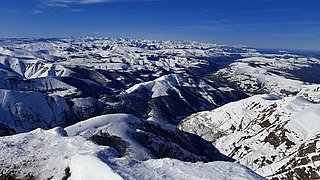
The Cantabrian Mountains or Cantabrian Range are one of the main systems of mountain ranges in Spain. They stretch for over 300 km (180 miles) across northern Spain, from the western limit of the Pyrenees to the Galician Massif in Galicia, along the coast of the Cantabrian Sea. Their easternmost end meets the Sistema Ibérico.
The Cantabrian Wars, sometimes also referred to as the Cantabrian and Asturian Wars, were the final stage of the two-century long Roman conquest of Hispania, in what today are the provinces of Cantabria, Asturias and León in northwestern Spain.

Cantabrian cuisine is the cuisine from Cantabria, an autonomous community in northern Spain. It includes seafood from the Cantabrian Sea, salmon and trout from the upper basins of the rivers, vegetables and dairy products from the valleys, and veal and game from the Cantabrian mountains.

The Battle of Santander was a battle fought in the War in the North campaign of the Spanish Civil War during the summer of 1937. Santander's fall on 26 August assured the Nationalist conquest of the province of Santander, now Cantabria. The battle devastated the Republic's "Army of the North"; 60,000 soldiers were captured by the Nationalists.

The Cantabria autonomous football team is the regional football team for Cantabria, Spain. They are not affiliated with FIFA or UEFA and therefore are only allowed to play friendly matches.
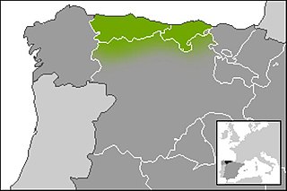
Cantabrian is a vernacular Romance linguistic variety, most often classified as part of the Asturleonese linguistic group. It is indigenous to the territories in and surrounding the Autonomous Community of Cantabria, in Northern Spain. The language is currently relegated to the rural dialects, while most of the population speaks a more or less standard version of Spanish.

The War in the North was the campaign of the Spanish Civil War in which the Nationalist forces defeated and occupied the parts of northern Spain that had remained loyal to the Republican government.

Campoo is a comarca (district) of Cantabria (Spain) located in the High Ebro. With an area of slightly more than 1,000 km2, it includes the municipalities of Hermandad de Campoo de Suso, Campoo de Enmedio, Campoo de Yuso, Valdeolea, Valdeprado del Río, Valderredible, Reinosa, Las Rozas de Valdearroyo, Santiurde de Reinosa, Pesquera, and San Miguel de Aguayo. The local inhabitants are called Campurrians . Its highest elevation is the Cuchillón peak, and the lowest is Pesquera, with the capital, Reinosa at 850 m.

The Valleys of the Saja and Nansa Rivers comprise an administrative comarca in Cantabria, Spain. It is formed by the valleys of said rivers, each one being a natural comarca of its own.

Entrambasaguas is a small municipality located in the autonomous community of Cantabria, Spain, 25 km south of the Bay of Santander. It is moderately mountainous, and the origin of the Aguanaz River, which once drove 23 watermills and merges with the Miera River. Limestone caves with Paleolithic rock art and burial sites from the Bronze Age exist. Iron was mined here from prehistoric times, used in the Royal Artillery Factory of La Cavada, which supplied the Armada, and eventually brought some wealth during the Renaissance. First mentioned in 1210, this rural area of Green Spain consists of six towns an area of 43.2 square km, totaling about 5,000 inhabitants as of 2015, having nearly doubled since 2005.

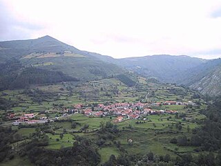
Luena is a municipality located in the autonomous community of Cantabria, Spain. According to the 2007 census, the municipality has a population of 831 inhabitants. Its capital is San Miguel de Luena. The municipality consists of a valley which runs from the Cantabrian Mountains to the North, until it reaches the valley of the river Pas. It is a markedly rural area, where the traditional economic activity evolves around the cow.
The Sierra del Escudo de Cabuérniga is a mountain range in Cantabria, Spain. It is a northern foothill of the Cantabrian Mountains, located between the main ranges and the Bay of Biscay. Its highest point is 927 m high Gándara.

The N-623 is a highway in northern Spain. It connects Burgos with Santander.

The Villano de Las Encartaciones is a Spanish breed of large working dog from the region of Las Encartaciones in the province of Biscay, in the Basque country; it is found also in Álava, in eastern Cantabria and in northern Burgos. The traditional use of the dogs is in management of the Monchina breed of cattle of Cantabria and the País Vasco, and particularly to assist with bringing the cattle down from the mountain pastures between October and December. In 2009 there were fewer than 200 dogs registered in the studbook.

El Soplao is a cave located in the municipalities of Rionansa, Valdáliga and Herrerías in Cantabria, Spain. It is considered unique for the quality and quantity of geological formations (speleothems) in its 17 miles length, 6 of which are open to the public. In it are formations such as helictites and curtains. Its formation dates back to the Mesozoic, in particular the Cretaceous period 240 million years ago. The entrance is at 540 metres in the Sierra Soplao Arnero.

Saja-Besaya Natural Park is Cantabrias largest natural park on the northern slope of the Cantabrian Mountains in West Central Cantabria, Spain. Its hunting reserve is approximately 1800km², the largest and most important in Spain.

La Marina is the name traditionally given to the area of Cantabria facing the sea, in contrast to La Montaña, its inland part. The differences between the two are orographic, climatic and ecological as well as anthropological and ethnographic. In the case of La Marina, which occupies only a third of the autonomous community, the orography and climate are gentle, the population density is much higher and, therefore, it has a higher level of development. Several of the largest population centers in the region are located in this area, with its capital, Santander, standing out. Chapter 2 of the Regional Land Use Plan of Cantabria defines La Marina as a distinguishable physical environment, with a milder climate and relief than inland Cantabria, and with a higher population development.

