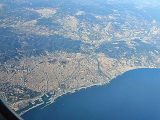
Barcelona is a province of eastern Spain, in the center of the autonomous community of Catalonia. The province is bordered by the provinces of Tarragona, Lleida, and Girona, and by the Mediterranean Sea. Its area is 7,726 km2 (2,983 sq mi). 5,609,350 people live in the province, of whom about 30% (1,620,343) live within the administrative limits of the city of Barcelona, which itself is contained in the Barcelona metropolitan area.

Federica Montseny Mañé was a Spanish anarchist, intellectual and Minister of Health during the Spanish Revolution of 1936, a social revolution that occurred in Spain in parallel to the Spanish Civil War.

Vallès Oriental[bəˈʎɛz uɾi.ənˈtal] is a comarca (county) in Catalonia, Spain. Its capital is Granollers. Along with Vallès Occidental it forms the grand comarca of Vallès.
Aiguafreda is a municipality in the comarca of Vallès Oriental, in the province of Barcelona, Catalonia, Spain. It is located near the Montseny massif. It has a population of 2,190 and occupies an area of 7.96 km².

Saldes is a municipality in the comarca of the Berguedà in Catalonia, Spain. It is situated at the foot of the Pedraforca mountain (2497 m) in the north of the comarca. Deposits of lignite are extracted commercially. The village is linked to Guardiola de Berguedà by a local road. The monastery Sant Sebastià del Sull is located in Saldes.

Sant Celoni is a municipality in the comarca of the Vallès Oriental in Catalonia, Spain. It is situated in the valley of the Tordera river between the ranges of Montseny and Montnegre. The main part of the town is on the left bank of the river. The former municipalities of Montnegre and Olzinelles now form part of the municipality of sant Celoni, which has the largest area in the comarca. The municipality is served by the AP-7 Motorway and the C-251 road, as well as by a station on the RENFE railway line between Barcelona and Girona.

Viladrau is a municipality in the comarca of Osona in Catalonia, Spain. It is situated in the south-east of the comarca, beneath the massifs of the Guilleries and the Montseny, and is served by the GE-520 road, which links the municipality with the comarca of the Selva and with the N-152 road at Tona. The local mineral water is well known.

Montseny is a mountain range west of the coastal hills north of Barcelona. It is part of the Catalan Pre-Coastal Range.

Sant Esteve de Palautordera is a municipality in the comarca of the Vallès Oriental in Catalonia, Spain. It forms part of the sub-comarca of Baix Montseny.

Cardedeu is a village in the comarca of Vallès Oriental in the province of Barcelona and autonomous community of Catalonia, Spain. It is near Granollers, the capital of Vallès Oriental, and it is placed between Serralada Litoral and Montseny.

Santa Maria de Palautordera is a village and municipality in the comarca of Vallès Oriental in the province of Barcelona and autonomous community of Catalonia, Spain.

Turó de l'Home is a mountain of Catalonia, part of the Montseny Massif. With its elevation of 1,712 m (5,617 ft) above sea level, it is the highest peak of the Montseny Massif.

Matagalls is one of the highest mountains of the Montseny Massif, Catalonia, Spain. It has an elevation of 1,697.9 metres above sea level.

The Catalan Pre-Coastal Range is a system of mountain ranges running parallel to the Mediterranean Sea coast in Catalonia. It is part of the Catalan Mediterranean System. Its main axis runs between the Catalan Transversal Range and the Serra de l'Espina, which connects with the Ports de Tortosa-Beseit, part of the Iberian System. The highest point is 1.706,7 m at the Montseny Massif.

Muntanya de Santa Bàrbara is a mountain that is part of the northwestern foothills of the Ports de Tortosa-Beseit, Catalonia, Spain. It has an elevation of 751.3 metres above sea level.

The Tordera is a river of Catalonia (Spain). It flows through the town of Tordera.

Llinars del Vallès is a village and a municipality in the comarca of Vallès Oriental in the province of Barcelona and autonomous community of Catalonia, Spain. That village forms part of the county of Baix Montseny. Its municipal term goes by the mountain of the Massís del Montseny to the Serralada Litoral. The dry agriculture is more abundant than the wet, that only predomines in the Mogent river. The forests are mediterranean, though in the Serralada Litoral there are also oaks and cork oaks.

Gualba is a municipality in Catalonia, Spain. It is located in Barcelona Province in the comarca of Vallès Oriental. As of 2014, the population was 1,429.


