Pulaski station (CTA Orange Line)

Last updated

Pulaski
 
4000W
5100S
Chicago 'L' rapid transit station
Platform at Pulaski (Orange), looking northeast.jpg
General information
Location5106 South Pulaski Road
Chicago, Illinois 60632
Coordinates 41°47′59″N87°43′28″W / 41.799756°N 87.724493°W / 41.799756; -87.724493
Owned by Chicago Transit Authority
Line(s)Midway Branch
Platforms1 island platform
Tracks2
Connections CTA buses
Construction
Structure typeElevated
Parking Aiga parking inv.svg 390 spaces
Bicycle facilitiesYes
AccessibleYes
History
OpenedOctober 31, 1993;30 years ago (1993-10-31)
Passengers
2020568,830 [1] Decrease2.svg 61.2%
Rank36 out of 143
Services
Preceding station Chicago "L" Following station
Midway Pictograms-nps-airport.svg
Terminus
Orange Line Kedzie
toward Loop
(Library)
Location
Pulaski station (CTA Orange Line)

Pulaski is an 'L' station on the CTA's Orange Line, which runs between Midway Airport and The Loop; it is situated between Midway Pictograms-nps-airport.svg and Kedzie stations. Pulaski is located at Pulaski Road and 51st Street on the Southwest Side of Chicago, Illinois. The station is within the Archer Heights neighborhood, which is both residential and commercial, and the station itself is in a commercial district on Pulaski Road. Pulaski opened on October 31, 1993, the opening date of the Orange Line.

Contents

The Pulaski station was proposed in 1980 and constructed from 1987 to 1993. When the station opened in 1993, it spurred commercial development in the surrounding area and led to a parking controversy on nearby residential streets. Pulaski consists of an elevated island platform above a station house which is set back from Pulaski Road. The station also includes a bus terminal and a park and ride lot. Nearly 1.4 million passengers boarded Orange Line trains at Pulaski in 2010. Trains serve Pulaski approximately every ten minutes during rush hour but are less frequent at other times. In addition to offering train service, Pulaski also connects to several CTA bus routes.

History

The Orange Line, including the Pulaski station, was first proposed in 1980 by Chicago Mayor Jane Byrne, who planned to fund the line using money from the canceled Crosstown Expressway project. U.S. Representative William Lipinski secured federal funding for the line in 1986 as a political favor from President Ronald Reagan, and Chicago Mayor Harold Washington signed a federal funding contract later that year. [2] Construction began on the line in 1987 and was completed in 1993; the total cost of the line was $500 million. [3] The Pulaski station was built over an abandoned Belt Railway of Chicago line which ran from 49th Street to Midway Airport. [4] Pulaski, along with the rest of the Orange Line, opened on October 31, 1993. The CTA only charged riders 25 cents during the station's first three days of service, which were considered a test run of the line. [2]

The Pulaski station spurred commercial development in the Archer Heights neighborhood. Area development began even before the station opened, as the Midway Square shopping mall opened at Pulaski Road and 51st Street in 1988 in anticipation of the potential customers the Orange Line would bring. [3] The station's opening continued the trend of development, and Pulaski station was credited with boosting business in Archer Heights and doubling property values in the neighborhood. [5] The station also created a parking problem in the neighborhood. The station's parking lot filled up as early as 7 A.M. most workdays, causing commuters to park on residential streets. The commuters prompted local residents to ban non-residents from parking on certain streets during daytime hours. [6]

Station layout

P
Platform level
Southbound      Orange Line toward Midway Pictograms-nps-airport.svg (Terminus)
Island platform, doors will open on the left
Northbound      Orange Line toward The Loop (Kedzie)
GStreet levelEntrance/Exit, station house

The Pulaski station was designed by the City of Chicago. The station house is at ground level and is set back from the street. It has a glass and steel façade, and most features within the station house are either made of stainless steel or painted white. The station's island platform is accessible from the station house via stairs, escalators, and an elevator. The platform serves the Orange Line's two tracks; the track to the Loop is located to the south, and the track to Midway located to the north. A canopy covers the entire platform. [7] A bus terminal is located to the north of the station. To the west of the bus terminal and north of the railroad tracks is the Pulaski park and ride lot. The park and ride lot has 390 spaces which cost $4 for 12 hours and is operated by Standard Parking. [8]

Pulaski serves the Archer Heights and West Elsdon neighborhoods of Chicago, which has both commercial and residential areas. Pulaski Road is primarily commercial, and most of the businesses on Pulaski Road rely on business from Orange Line commuters going to and from the station. [5] However, side streets near the station such as Keeler Avenue are primarily residential. [6] Curie Metropolitan High School, at Pulaski Road and Archer Avenue, is accessible from Pulaski station. [9] The Polish Highlanders Alliance of North America, the cultural pillar of Chicago's Góral community, is also located nearby at 4808 S. Archer Avenue. [10]

Train service

Pulaski serves the CTA's Orange Line, which runs from The Loop to Midway Airport. Pulaski is the second inbound station on the line after Midway Pictograms-nps-airport.svg and is situated between the Midway and Kedzie stations. Pulaski is open from 3:55 A.M. to 1:20 A.M. on weekdays, 4:30 A.M. to 1:20 A.M. on Saturdays, and 5:30 A.M. to 11:50 P.M. on Sundays. [11] Trains run approximately every ten minutes during rush hour and midday operation on all days, with more limited service in the early morning and night. [12] Pulaski is two minutes from Midway and nineteen minutes from the first station in The Loop, Harold Washington Library – State/Van Buren. [12] [13] [14] 1,393,509 passengers boarded at Pulaski in 2010; the station's ridership was the third-highest of any Orange Line station outside of The Loop, behind Midway Pictograms-nps-airport.svg and Roosevelt. [15]

Bus connections

CTA

In addition to rail service, several CTA bus routes stop at Pulaski. The 53A South Pulaski runs north and south on Pulaski Road from the station during most daytime hours. [16] The 62 Archer, which runs 24/7, also serves the Pulaski station through a stop on nearby Archer Avenue. [17] The major Chicago streets, Pulaski Road, 51st Street, and Archer Avenue, are also accessible from the Pulaski station. [18] [19]

Related Research Articles

<span class="mw-page-title-main">Chicago "L"</span> Rapid transit system in Chicago, Illinois, US

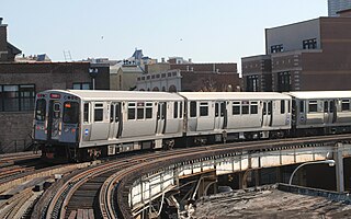
The Chicago "L" is the rapid transit system serving the city of Chicago and some of its surrounding suburbs in the U.S. state of Illinois. Operated by the Chicago Transit Authority (CTA), it is the fourth-largest rapid transit system in the United States in terms of total route length, at 102.8 miles (165.4 km) long as of 2014, and the third-busiest rapid transit system in the United States. In 2016, the "L" had 1,492 rail cars, eight different routes, and 145 train stations. In 2023, the system had 117,447,000 rides, or about 350,900 per weekday in the first quarter of 2024.

<span class="mw-page-title-main">Red Line (CTA)</span> Rapid transit line in Chicago

The Red Line is a rapid transit line in Chicago, run by the Chicago Transit Authority (CTA) as part of the Chicago "L" system. It is the busiest line on the "L" system, with an average of 93,457 passengers boarding each weekday in 2022. The route is 26 miles (42 km) long with a total of 33 stations. It runs elevated from the Howard station in the Rogers Park neighborhood on the North Side, through a subway on the Near North Side, Downtown, and the South Loop, and then through the Dan Ryan Expressway median to 95th/Dan Ryan in the Roseland neighborhood on the South Side.

<span class="mw-page-title-main">Orange Line (CTA)</span> Rapid transit line in Chicago, Illinois

The Orange Line is a rapid transit line in Chicago, Illinois, operated by the Chicago Transit Authority (CTA) as part of the Chicago "L" system. It is approximately 13 miles (21 km) long and runs on elevated and at grade tracks and serves the Southwest Side, running from the Loop to Midway International Airport. As of 2022, an average of 15,098 riders board Orange Line trains on weekdays.

<span class="mw-page-title-main">Blue Line (CTA)</span> Rapid transit line in Chicago

The Blue Line is a 26.93-mile-long (43.34 km) Chicago "L" line which extends through The Loop from O'Hare International Airport at the far northwest end of the city, through downtown via the Milwaukee–Dearborn subway and across the West Side to its southwest end at Forest Park, with a total of 33 stations. At about 27 miles, it is the longest line on the Chicago "L" system and second busiest, and one of the longest local subway/elevated lines in the world. It has an average of 64,978 passengers boarding each weekday in 2022.

<span class="mw-page-title-main">Brown Line (CTA)</span> Rapid transit line in Chicago, Illinois

The Brown Line of the Chicago "L" system, is an 11.4-mile (18.3 km) route with 27 stations between Chicago's Albany Park neighborhood and downtown Chicago. It runs completely above ground and is almost entirely grade-separated. It is the third-busiest 'L' route, with an average of 28,315 passengers boarding each weekday in 2022.

<span class="mw-page-title-main">Howard station (CTA)</span> Chicago "L" station

Howard is an 'L' station in Chicago, Illinois on the North Side Main Line. It is the northern terminus of the Red Line and the southeastern terminus of the Yellow Line; it also serves the Purple Line, for which it is the southern terminus at non-rush hour times on weekdays and all day on weekends. Trains on the Chicago North Shore and Milwaukee Railroad also stopped at Howard from 1926 until that line was abandoned in 1963.

<span class="mw-page-title-main">Pink Line (CTA)</span> Rapid transit line in Chicago, Illinois

The Pink Line is an 11.2 mi (18.0 km) rapid transit line in Chicago, run by the Chicago Transit Authority (CTA) as part of the Chicago "L" system. It is the CTA's newest rail line and began operation for a 180-day trial period on June 25, 2006, running between 54th/Cermak station in Cicero, Illinois and the Loop in downtown Chicago. As the line enters downtown Chicago, it begins to share tracks with Green Line trains on Lake Street. This connection is handled by the previously non-revenue Paulina Connector set of tracks. In 2022, over 3 million passengers boarded Pink Line trains.

<span class="mw-page-title-main">Kedzie station (CTA Brown Line)</span> Chicago "L" station

Kedzie is an 'L' station on the CTA's Brown Line. It is an at-grade station located in Chicago's Albany Park neighborhood at 4648 North Kedzie, with an auxiliary entrance at 4649 North Spaulding Avenue. The adjacent stations are Kimball, the terminus of the line about one third of a mile (0.536 km) to the north west, and Francisco, which is located about one third of a mile (0.536 km) to the east.

<span class="mw-page-title-main">Pulaski station (CTA Green Line)</span> Chicago "L" station

Pulaski is a station on the Chicago Transit Authority's 'L' system, serving the Green Line. Pulaski is located at the intersection of Lake Street and Pulaski Road in the West Garfield Park neighborhood of Chicago, Illinois. The station opened in March 1894.

<span class="mw-page-title-main">Austin station (CTA Green Line)</span> Chicago "L" station

Austin is a station on the Chicago Transit Authority's 'L' system. It is located between the Ridgeland and Central stations on the Green Line, which runs from Harlem/Lake and to Ashland/63rd and Cottage Grove. The station is located at the intersection of Austin Boulevard and Corcoran Place in the Austin neighborhood on Chicago's West Side and borders the village of Oak Park.

<span class="mw-page-title-main">O'Hare station</span> Chicago "L" station

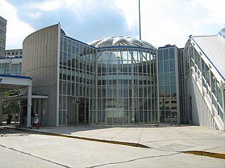
O'Hare is a Chicago "L" station located at O'Hare International Airport, 17 miles (27 km) northwest of The Loop. The northwestern terminus of the Chicago Transit Authority's Blue Line, it is a subway station with two island platforms serving three tracks, situated under the parking garage for Terminals 1, 2, and 3. Trains are scheduled to depart from O'Hare every 2–7 minutes during rush-hour periods and take about 40 minutes to travel to the Loop. It is the westernmost station of the Chicago 'L' system. It is also the only station without coordinates in Chicago's grid system, the only underground terminus, and is the only terminal that does not directly connect to any CTA or Pace buses. Uniquely among "L" stations, it serves airport passengers and employees exclusively, and is not accessible by foot beyond airport terminals 1, 2, and 3. It is also one of two terminals that does not have a yard assigned to it.

<span class="mw-page-title-main">Halsted station (CTA Orange Line)</span> Chicago "L" station

Halsted station is an "L" station on the CTA Orange Line, located near the intersection of Halsted Street and Archer Avenue in the Bridgeport neighborhood of Chicago. The station opened in 1993 as part of the extension to Midway Airport. A previous railroad station just to the east opened in 1902 and served the Metra Heritage Corridor until 1984.

<span class="mw-page-title-main">Ashland station (CTA Orange Line)</span> Chicago "L" station

Ashland is a station on the Chicago Transit Authority's 'L' system, serving the Orange Line. It is located at the intersection of Ashland Avenue and 31st Street near the Stevenson Expressway. Although located within the Lower West Side community area, the station mostly serves the Bridgeport and McKinley Park neighborhoods.

<span class="mw-page-title-main">35th/Archer station</span> Chicago "L" station

35th/Archer is an 'L' station on the CTA's Orange Line, located in the McKinley Park neighborhood. The station has a Park 'n' Ride lot with 70 spaces.

<span class="mw-page-title-main">Midway station (CTA)</span> Chicago "L" station

Midway is an 'L' station on the CTA's Orange Line. It is the southwestern terminus of the Orange Line and serves Midway International Airport in Chicago, the city's second-largest airport. The turnstiles at the station's entrance are somewhat wider than most to accommodate airport passengers and their luggage. The station, along with the rest of the Orange Line, opened on October 31, 1993 after a long wait by Chicago's southwest side for 'L' access. It is also the closest station to SeatGeek Stadium, former home of the Chicago Fire, which is approximately 4 miles away. Although in the Garfield Ridge community area, the station serves many residents in the West Elsdon and West Lawn neighborhoods. Unlike O'Hare , passengers using Midway station do not pay an airport surcharge in addition to the standard "L" fare.

<span class="mw-page-title-main">Cumberland station (CTA)</span> Chicago "L" station

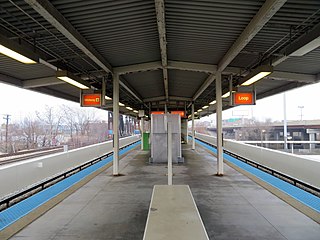
Cumberland is a station on the Chicago Transit Authority's 'L' system. Situated on the Blue Line between Rosemont and Harlem, the station is located in the median of the Kennedy Expressway at Cumberland Avenue in the O'Hare community area’s Schorsch Forest View neighborhood on Chicago's Northwest Side. It is also in close proximity to both the Norwood Park neighborhood and the city of Park Ridge as well as the village of Norridge. The area surrounding the station consists of mixed commercial and residential development.

<span class="mw-page-title-main">Harlem station (CTA Blue Line O'Hare branch)</span> Chicago "L" station

Harlem is a Chicago "L" station serving the Blue Line's O'Hare branch in Chicago's Norwood Park neighborhood. It is not to be confused with the other Harlem Blue Line station. Trains run from Harlem every 2–7 minutes during rush hour, and take 30–45 minutes to travel to the Loop. O'Hare-bound trains take 10 minutes to reach the airport from Harlem. The station is located in the median of the Kennedy Expressway.

<span class="mw-page-title-main">Pulaski station (CTA Pink Line)</span> Chicago rapid transit station

Pulaski is an 'L' station on the CTA's Pink Line, located in the North Lawndale neighborhood. Pulaski opened on June 16, 1902, as part of the Douglas Park branch of the Metropolitan West Side Elevated Railroad. It served as the terminus of that line until its 1907 extension to 48th Avenue.

<span class="mw-page-title-main">Jefferson Park Transit Center</span> Transport hub in Chicago, Illinois

The Jefferson Park Transit Center is an intermodal passenger transport hub in the Jefferson Park neighborhood of Chicago, Illinois. It serves as a station for rail and also as a bus terminal. Jefferson Park Transit Center's railroad station is on Metra's Union Pacific Northwest Line, with the station located at 4963 North Milwaukee Avenue. Jefferson Park is 9.1 miles (14.6 km) away from Ogilvie Transportation Center in downtown Chicago, the inbound terminus of the Union Pacific Northwest Line. Under Metra's zone-based fare system, Jefferson Park is in zone 2. As of 2018, Jefferson Park is the 97th busiest of Metra's 236 non-downtown stations, with an average of 510 weekday boardings.

<span class="mw-page-title-main">Ravenswood branch</span>

The Ravenswood branch is a 4.7 mi (7.6 km) long branch of the Chicago "L" in Chicago, Illinois. Operated by the Chicago Transit Authority, it carries the Brown Line. As of February 2013, an average of 30,949 passengers are served each weekday on this branch.

References

  1. "Annual Ridership Report Calendar Year 2020" (PDF). Chicago Transit Authority, Ridership Analysis and Reporting. January 19, 2021. Retrieved May 31, 2021.
  2. 1 2 Washburn, Gary (October 31, 1993). "Midway 'L' Finally Ready to Roll - 13 Years Later, CTA Set to Open Southwest Side Line". Chicago Tribune . p. 1. Retrieved March 22, 2018 via Newspapers.com. Lock-green.svg
  3. 1 2 Borcover, Alfred (October 10, 1993). "Quickening the Pace - Rapid Transit Line Spurs Interest in Development, Housing on Southwest Side". Chicago Tribune.
  4. Garfield, Graham. "Orange Line: Midway". Chicago-l.org. Retrieved June 8, 2009.
  5. 1 2 Kerrill, Tamara (July 31, 1995). "Southwest Side Rides Orange Line to Boom Times". Chicago Sun-Times .
  6. 1 2 Kerrill, Tamara (April 28, 1994). "When Orange Line Riders Park, Residents See Red". Chicago Sun-Times.
  7. Garfield, Graham. "Pulaski". Chicago-L.org. Retrieved June 8, 2009.
  8. "Park & Ride: Orange Line". Chicago Transit Authority. Retrieved June 8, 2009.
  9. "Curie Metro High School - Directions". Curie Metropolitan High School. Archived from the original on July 25, 2011. Retrieved June 8, 2009.
  10. "Contact - The Seat of the Union Podhalan" (in Polish). Polish Highlanders Alliance of North America. Archived from the original on December 19, 2007. Retrieved June 28, 2009.
  11. "Orange Line Route Guide". Chicago Transit Authority. Retrieved June 8, 2009.
  12. 1 2 "Pulaski Station Timetable" (PDF). Chicago Transit Authority. Archived from the original (PDF) on March 15, 2009. Retrieved June 8, 2009.
  13. "Midway Station Timetable" (PDF). Chicago Transit Authority. Archived from the original (PDF) on March 15, 2009. Retrieved June 8, 2009.
  14. "Library Station Timetable" (PDF). Chicago Transit Authority. Archived from the original (PDF) on March 15, 2009. Retrieved June 8, 2009.
  15. "Annual Ridership Report: Calendar Year 2011" (PDF). Chicago Transit Authority. Archived from the original (PDF) on February 4, 2018. Retrieved February 13, 2012.
  16. "53A South Pulaski". Chicago Transit Authority. Retrieved June 8, 2009.
  17. "62 Archer". Chicago Transit Authority. Retrieved June 8, 2009.
  18. Major Streets (PDF) (Map). City of Chicago. 2004. Retrieved July 12, 2009.[ permanent dead link ]
  19. Chicago Public Transit (PDF) (Map). City of Chicago. 2004. Retrieved July 12, 2009.[ permanent dead link ]