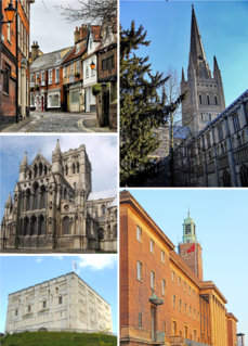
Norwich is a city and district of Norfolk, England, of which it is the county town. Norwich is by the River Wensum about 100 miles (160 km) north-east of London, 40 miles (64 km) north of Ipswich and 65 miles (105 km) east of Peterborough. As the seat of the See of Norwich, with one of the country's largest medieval cathedrals, it is the largest city in East Anglia.

The Marriott's Way is a long-distance footpath, cycle-path and bridleway between Norwich and Aylsham, Norfolk, England. It forms part of the National Cycle Network (NCN) and the red route of Norwich's Pedalways cycle path network. It is open to walkers, cyclists and horse riders. Its total length is 24.6 miles (39.5 km). It has a mixture of surfaces; tarmac, compacted gravel, and earth. The name of the route originates from the chief engineer and manager of the Midland and Great Northern Joint Railway (M&GNJR), William Marriott, who held the position for 41 years.

The River Wensum is a chalk river in Norfolk, England and a tributary of the River Yare, despite being the larger of the two rivers. The river is a biological Site of Special Scientific Interest and Special Area of Conservation.

Fakenham is a market town and civil parish in Norfolk, England. It is situated on the River Wensum, about 25 miles north west of Norwich. The town is the junction of several local roads, including the A148 from King's Lynn to Cromer, the A1067 to Norwich and the A1065 to Swaffham.

Norwich Castle is a medieval royal fortification in the city of Norwich, in the English county of Norfolk. It was founded in the aftermath of the Norman conquest of England when William the Conqueror (1066–1087) ordered its construction because he wished to have a fortified place in the town of Norwich. It proved to be one of his two castles in East Anglia, the other being Wisbech. In 1894 the Norwich Museum moved to Norwich Castle and it has been a museum ever since. The museum & art gallery holds significant objects from the region, especially works of art, archaeological finds and natural history specimens.

Costessey is a civil parish situated 4 miles (6.4 km) west of Norwich in Norfolk, England. The parish comprises two settlements: the long-established town of Costessey, and New Costessey, which developed during the first half of the 20th century and has become a suburb of Norwich. The two settlements are separated by the River Tud and by arable land. Costessey's northern boundary with Taverham, Drayton and Hellesdon follows the course of the River Wensum.

Norwich Cathedral is an Anglican cathedral in Norwich, Norfolk, dedicated to the Holy and Undivided Trinity. It is the cathedral church for the Church of England Diocese of Norwich and is one of the Norwich 12 heritage sites.
North Elmham is a village and civil parish in the English county of Norfolk. It covers an area of 7.41 sq mi (19.2 km2) and had a population of 1,428 in 624 households at the 2001 census, including Gateley and increasing slightly to 1,433 at the 2011 Census. For the purposes of local government, it falls within the Elmham and Mattishall division of Norfolk County Council and the Upper Wensum ward of Breckland District Council. The village is located along the B1145 a route which runs between King's Lynn and Mundesley.

Gateley is a village and civil parish in the Breckland district of Norfolk, England.

Watts Naval School was originally the Norfolk County School, a public school set up to serve the educational needs of the 'sons of farmers and artisans'. The school was then operated by Dr Barnardo's until its closure in 1953.

Billingford is a village and civil parish in the Breckland district of Norfolk, England, about 3+1⁄2 miles (5.6 km) north of East Dereham. The village is just north of the River Wensum, which forms the southern boundary of the parish. The village is on the B1145 road, which links King's Lynn and Mundesley. The 2011 Census recorded the parish population as 253.

Bylaugh is a civil parish in Norfolk, England 4.5 miles (7.2 km) north-east of East Dereham and 13.5 miles (21.7 km) WNW of Norwich. For the purposes of local government it falls within the Upper Wensum Ward of Breckland District Council and the Elmham and Mattishall Division of Norfolk County Council. According to the 2001 census it had a population of 65. At the 2011 census the population remained less than 100 and was included in the civil parish of Sparham.
Lyng is a village and civil parish in the English county of Norfolk. It is situated on the River Wensum, some 10 km (6.2 mi) north-east of the town of East Dereham and 20 km (12 mi) north-west of the city of Norwich.

Helhoughton is a village and civil parish in Norfolk, England. It is 4.2 miles (6.8 km) west-south-west of the town of Fakenham, 29.3 miles (47.2 km) west-northwest of Norwich and 112 miles (180 km) north-northeast of London. The nearest railway station is at Sheringham for the Bittern Line which runs between Sheringham, Cromer and Norwich. The nearest airport is Norwich International Airport. The parish had, in the 2001 census, a population of 197, rising to 346 at the 2011 Census. For the purposes of local government, the parish falls within the district of North Norfolk.

Friars Quay is a residential development and an example of a high density, urban design of the 1970s. The development is located in the Colegate area at the centre of Norwich, Norfolk, bounded on one side by the River Wensum and by a park and two notable bridges to the east and west. Several historic churches surround the site creating an attractive and varied landscape. The population is included in the Mancroft ward of Norwich City.
Lenwade is a village in the civil parish of Great Witchingham, Norfolk, situated in the Wensum Valley adjacent to the A1067 road 14 miles (23 km) south-east of Fakenham and some 11 miles (18 km) north-west of Norwich. The River Ainse joins the Wensum at Lenwade. The population of the village is included in the civil parish of Great Witchingham.

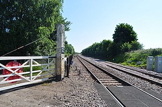
Trowse was a station on the Great Eastern Main Line just south of Norwich. It was opened around the same time as Norwich Thorpe, and was intended to provide a short commute from the outer suburbs of Norwich.
Spink's Lane was a railway station in Wymondham. It was opened very briefly in 1845 to trains on the line from Norwich.

Thorpe Hamlet is a suburb of Norwich, to the east of the city centre, in the Norwich District, in the English county of Norfolk. It was constituted a separate ecclesiastical parish March 9, 1852, from the civil parish of Old Thorpe, and in 1912, was in the rural deanery of Blofield.
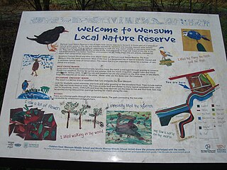
Wensum Local Nature Reserve or Wensum Valley is a Local Nature Reserve in Norwich in the English county of Norfolk. The reserve consists of two sites; Mile Cross Marsh52.6419°N 1.2657°E and Sycamore Crescent Wood which are linked by the Riverside Path a public footpath via the Sycamore Crescent footbridge

