
Honduras is a country in Central America. Honduras borders the Caribbean Sea and the North Pacific Ocean. Guatemala lies to the west, Nicaragua south east and El Salvador to the south west. Honduras is the second largest Central American republic, with a total area of 112,890 square kilometres (43,590 sq mi).

Ahuachapán is a city, and municipality, and the capital of the Ahuachapán Department in western El Salvador. The municipality, including the city, covers an area of 244.84 km² and as of 2007 has a population of 110,511 people. Situated near the Guatemalan border, it is the westernmost city in the country and is the center of an agricultural region producing primarily coffee.

Nueva Concepción is a municipality in the Chalatenango department of El Salvador.

The Río Grande de Santiago, or Santiago River, is a river in western Mexico. It flows westwards from Lake Chapala through the states of Jalisco and Nayarit to empty into the Pacific Ocean. It one of the longest rivers in Mexico, measuring up 433 km (269 mi) long.
Access to drinking water and sanitation in El Salvador has been increased significantly. A 2015 conducted study by the University of North Carolina called El Salvador the country that has achieved the greatest progress in the world in terms of increased access to water supply and sanitation and the reduction of inequity in access between urban and rural areas. However, water resources are heavily polluted and the great majority of wastewater is discharged without any treatment into the environment. Institutionally a single public institution is both de facto in charge of setting sector policy and of being the main service provider. Attempts at reforming and modernizing the sector through new laws have not borne fruit over the past 20 years.

The Lempa River is a 422-kilometre (262 mi) long river in Central America.

Copinula River is a medium stream in the Sonsonate department of El Salvador, which has moderate to large quantities of fresh water year round, especially from early May through October.
Banderas River is a river located in the southern part of the Ahuachapán Department of El Salvador. Precipitations along the river are suitable for municipal water, irrigation, and water wells.
Comalapa River is a medium-sized stream in La Paz, El Salvador, which has large to very large quantities of fresh water year round, especially from early May through October.
El Guayabo River is a medium stream in El Salvador, which has moderate to large quantities of fresh water year round, especially from early May through October.
El Molino River is the name of two medium streams in El Salvador.
Cimarron Hydroelectric Power Project a hydroelectric power plant in El Salvador, that was to start construction in 2010. The plant would have been be located in the upper basin of the Lempa River, upstream of the Cerrón Grande Hydroelectric Dam. The proposed location of the dam was between the towns of Agua Caliente, Chalatenango on the left shore and Metapán, Santa Ana, on the right shore. A tunnel would divert water from the Lempa River to a powerhouse and substation to be built near Agua Caliente. With an estimated capacity of 261 megawatts, the project would have increased El Salvador's total generation capacity by almost 25%.
Water resources management in El Salvador is characterized by difficulties in addressing severe water pollution throughout much of the country's surface waters due to untreated discharges of agricultural, domestic and industrial run off. The river that drains the capital city of San Salvador is considered to be polluted beyond the capability of most treatment procedures.
El Salvador competed at the 2016 Summer Olympics in Rio de Janeiro, Brazil, from 5 to 21 August 2016. This was the nation's eleventh appearance at the Summer Olympics, although it first competed in 1968.
El Salvador sent a delegation to compete in the 2016 Summer Paralympics in Rio de Janeiro in Brazil from 7 to 18 September 2016. This was the country's fifth successive appearance in the Summer Paralympics since debuting at the 2000 Summer Paralympics. The Salvadoran delegation to Rio consisted of one athlete, powerlifter Herbert Aceituno, who qualified for the Games through his world ranking of 13th and his participation was confirmed by the International Paralympic Committee in August 2016. He failed to lift 185 kilograms (408 lb) in three attempts during the men's 72 kg tournament and was therefore not ranked in the final standings by the judges.

Potential Tropical Cyclone Seventeen-E was a tropical disturbance that caused damaging floods in Southern Mexico, Guatemala, and El Salvador in mid-October 2019. A tropical wave entered the Eastern Pacific Ocean during October 13–14, and a low-pressure area developed by October 14 to the west of Nicaragua. Convection, also known as thunderstorm activity, associated with the system increased in both intensity and extent during October 15, while the system was south of Guatemala. The National Hurricane Center initiated advisories on the system as Potential Tropical Cyclone Seventeen-E on October 16, anticipating that the system would become a tropical cyclone before reaching the southern coast of Mexico. During its existence as a potential tropical cyclone, Seventeen-E had winds of 35 mph and a pressure of 1,005 mbar (29.68 inHg). As the storm tracked northwestward towards the coast, its structure decayed, and the chance of tropical cyclogenesis decreased markedly. The disturbance made landfall between Bahias de Huatulco and Salina Cruz, Oaxaca, during mid-day October 16 and dissipated a few hours later.
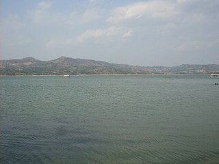
The Cerrón Grande Reservoir, also known locally as Lake Suchitlán, is a reservoir in northern El Salvador and the largest body of fresh water in the country. The reservoir was filled between 1973 and 1976, subsequent to the construction of the Cerrón Grande Hydroelectric Dam. The Cerrón Grande Reservoir is among the most polluted bodies of fresh water in Central America.
