Pump Branch

Last updated

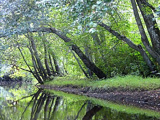
The Pump Branch is a 7.7-mile-long (12.4 km) [1] tributary of Albertson Brook in southern New Jersey in the United States. [2]

Tributary stream or river that flows into a main stem river or lake

A tributary or affluent is a stream or river that flows into a larger stream or main stem river or a lake. A tributary does not flow directly into a sea or ocean. Tributaries and the main stem river drain the surrounding drainage basin of its surface water and groundwater, leading the water out into an ocean.

Albertson Brook, also called Albertsons Brook, is the name of Nescochague Creek upstream of the confluence with Great Swamp Brook in the southern New Jersey Pine Barrens in the United States.

New Jersey State of the United States of America

New Jersey is a state in the Mid-Atlantic and Northeastern regions of the United States. It is located on a peninsula, bordered on the north and east by the state of New York, particularly along the extent of the length of New York City on its western edge; on the east, southeast, and south by the Atlantic Ocean; on the west by the Delaware River and Pennsylvania; and on the southwest by the Delaware Bay and Delaware. New Jersey is the fourth-smallest state by area but the 11th-most populous, with 9 million residents as of 2017, and the most densely populated of the 50 U.S. states; its biggest city is Newark. New Jersey lies completely within the combined statistical areas of New York City and Philadelphia. New Jersey was the second-wealthiest U.S. state by median household income as of 2017.

Contents

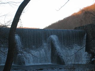
The Pump Branch arises at Virginia Lake in Winslow, flows under and along the former Atlantic City Railroad main line to the hamlet of Cedar Brook, where it turns east and is dammed to form Hobb Lake, in the vicinity of Bates Mill. Just downstream is another series of dams and lakes, built for the summer camp, Camp Haluwasa. Passing through Ancora, it joins with Blue Anchor Brook to form Albertson Brook.

Winslow Township, New Jersey Township in New Jersey

Winslow Township is a township in Camden County, New Jersey, United States. As of the 2010 United States Census, the township's population was 39,499, reflecting an increase of 4,888 (+14.1%) from the 34,611 counted in the 2000 Census, which had in turn increased by 4,524 (+15.0%) from the 30,087 counted in the 1990 Census.

Atlantic City Railroad

The Atlantic City Railroad was a Philadelphia and Reading Railway subsidiary that became part of Pennsylvania-Reading Seashore Lines in 1933. At the end of 1925 it operated 161 miles of road on 318 miles of track; that year it reported 43 million ton-miles of revenue freight and 204 million passenger-miles.

Cedar Brook, New Jersey Unincorporated community in New Jersey, United States

Cedar Brook is an unincorporated community located within Winslow Township, in Camden County, New Jersey, United States. Route 73 and County Route 536 serve as major roads in Cedar Brook.

See also

Related Research Articles

Au Sable River (Michigan) river in Michigan

The Au Sable River in Michigan, United States runs approximately 138 miles (222 km) through the northern Lower Peninsula, through the towns of Grayling and Mio, and enters Lake Huron at Au Sable. It is considered one of the best brown trout fisheries east of the Rockies and has been designated a blue ribbon trout stream by the Michigan Department of Natural Resources. In French, au sable literally means "at the sand." A 1795 map calls it the Beauais River.

Raccoon Creek is a 22.6-mile-long (36.4 km) tributary of the Delaware River in southern New Jersey in the United States.

Nescochague Creek is a 6.4-mile-long (10.3 km) tributary of the Mullica River in southern New Jersey in the United States. The creek starts just northwest of Hammonton, arcs along the southern boundary of Wharton State Forest, and joins the Mullica River just above County Route 542.

Batsto River river in the United States of America

The Batsto River is a 22.9-mile-long (36.9 km) tributary of the Mullica River in the southern New Jersey Pine Barrens in the United States. The river also drains 49.42 square miles of land.

Pascack Brook is a tributary of the Hackensack River in Bergen County, New Jersey, United States.

The North Branch Rancocas Creek is a 31-mile-long (50 km) tributary of Rancocas Creek in southwestern New Jersey in the United States.

South Branch Raritan River river in the United States of America

The South Branch Raritan River is a 50-mile-long (80 km) tributary of the Raritan River in central New Jersey in the United States.

West Creek is a 12.3-mile-long (19.8 km) tributary of Delaware Bay in Cape May County, New Jersey in the United States.

Stony Brook (Millstone River tributary) tributary of the Millstone River in Mercer County, New Jersey

Stony Brook, also known as Stoney Brook, is a tributary of the Millstone River in Hunterdon and Mercer counties, New Jersey, in the United States.

Millstone River river in New Jersey, United States

The Millstone River is a 38.6-mile-long (62.1 km) tributary of the Raritan River in central New Jersey in the United States.

Clove Brook is a 12.0-mile-long (19.3 km) tributary of Papakating Creek in Sussex County, New Jersey in the United States.

Greenwood Branch is a 9.3-mile-long (15.0 km) tributary of the North Branch Rancocas Creek in the southern New Jersey Pine Barrens in the United States.

Mount Misery Brook is a tributary of Greenwood Branch in the southern New Jersey Pine Barrens in the United States.

Great Swamp Brook is a 9.1-mile-long (14.6 km) tributary of Nescochague Creek in the southern New Jersey Pine Barrens in the United States.

The Chepachet River is a river in the U.S. state of Rhode Island. It flows 5.2 miles (8.4 km). There are eight dams along the river's length.

Middle Brook (Raritan River tributary)

Middle Brook is a tributary of the Raritan River in Somerset, New Jersey, in the United States. The stream can be referred to as Rha-weigh-weiros, a Native American name meaning "running from a deep hole", on early maps of the area.

The South Branch Penobscot River is a river in Somerset County, Maine. Its source, Penobscot lake, the north end of which at is about 1,000 feet (300 m) from the Canada–United States border in Sandy Bay. This section of the border runs along the height of land separating the watersheds of the Penobscot River and the Monument River, which feeds into the Saint Lawrence River.

Hobb Lake is a major reservoir located in Winslow Township, New Jersey. It was once open for public swimming and was called "The Lake of the Four Fountains". It is formed by the Pump Branch, a tributary of Albertson Brook.

Neepaulakating Creek stream in Sussex County, New Jersey

Neepaulakating Creek is a 2.4-mile long (3.8 km) tributary of Papakating Creek in Wantage Township in Sussex County, New Jersey in the United States. It is one of three streams feeding the Papakating Creek, a major contributor to the Wallkill River. Although the stream was dammed in the 1950s to create Lake Neepaulin as the focal point of a private residential development, the stream did not receive a name until 2002. Residents chose a name that combined elements of the names "Neepaulin" and "Papakating", and submitted a proposal to the United States Board of Geographic Names. The name was approved in 2004.

References

  1. U.S. Geological Survey. National Hydrography Dataset high-resolution flowline data. The National Map, accessed April 1, 2011
  2. Gertler, Edward. Garden State Canoeing, Seneca Press, 2002. ISBN   0-9605908-8-9

Coordinates: 39°42′24″N74°52′49″W / 39.706704°N 74.880141°W / 39.706704; -74.880141

Geographic coordinate system Coordinate system

A geographic coordinate system is a coordinate system that enables every location on Earth to be specified by a set of numbers, letters or symbols. The coordinates are often chosen such that one of the numbers represents a vertical position and two or three of the numbers represent a horizontal position; alternatively, a geographic position may be expressed in a combined three-dimensional Cartesian vector. A common choice of coordinates is latitude, longitude and elevation. To specify a location on a plane requires a map projection.