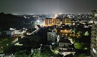
Dhanbad is the second-most populated city in the Indian state of Jharkhand after Jamshedpur. It ranks as the 39th largest city in India and is the 33rd largest million-plus urban agglomeration in India. Dhanbad shares its land borders with Paschim Bardhaman district and Purulia district of West Bengal and Bokaro, Giridih and Jamtara districts of Jharkhand. The city is called the 'Coal Capital of India' for housing one of the largest coal mines in the country. The prestigious institute, Indian School of Mines is situated in Dhanbad. Apart from coal, it has also grown in information technology.
Bokaro district is one of the most industrialized zones in India. It is one of the twenty-four districts of the Jharkhand state, India. It was established in 1991 by carving out one subdivision consisting of two blocks from Dhanbad district and six blocks from Giridih district. It is the part of State Capital Region (SCR).

Grand Chord is part of the Howrah–Gaya–Delhi line and Howrah–Prayagraj–Mumbai line. It acts as a link between Sitarampur, (Asansol), and Pt. Deen Dayal Upadhyay Junction,, previously known as Mughalsarai Junction, and covers a stretch of 450.7 km (280.1 mi). The Coal India Corridor line that branches off from Dhanbad Junction and rejoins the Grand Chord at Son Nagar Junction is another major coal loading hub. It is a fully electrified, quadruple line section from Pt. Deen Dayal Upadhyay to Son Nagar and double line section from Son Nagar to Sitarampur. There are plans to triple the lines from Son Nagar to Dhanbad to accommodate the increasing traffic.. The entire line lies under the jurisdiction of three divisions, Mughalsarai railway division, Dhanbad railway division and Asansol railway division. The Grand chord section is the lifeline of the country, 2nd busiest railway section of India after Ghaziabad, Uttar Pradesh to Pt. Deen Dayal Upadhyay Junction, Uttar Pradesh Main Line section, on which coal, steel and other important goods are moved from Eastern section to Western and Northern sections of the country. In the down direction, the traffic consists of mostly food grains, fertilizers and empty wagons for coal loading in the Jharkhand and West Bengal coal fields. Pt. Deen Dayal Upadhyay Junction is a transit division and the main objective is to maintain mobility of high density traffic. The present capacity of the Grand Chord is being optimally utilized. Traversing through Chota Nagpur Plateau of Jharkhand as well as parts of the fertile Gangetic plains of Bihar, the Grand Chord covers a stretch of 450.7 km (280.1 mi). The Grand Chord is renowned for its remarkable controlling of passenger traffic, despite being burdened with freight traffic.

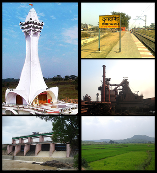
Bokaro, officially known as Bokaro Steel City, is a large and planned city in Jharkhand, India. It is the fourth most populous city in the state and one of the first planned cities of India. Bokaro is the administrative headquarters of Bokaro district. The city is located on the banks of Garga River and on the fringes of Bokaro river and is surrounded by hill ranges at Giridih and Ramgarh districts. It is one of the most peaceful cities in India. As per 2011 census, the city's population was 563,417 and 1,100,000 of its metropolitan area. The city span across 183 km in geographic area.

Dhanbad district is one of the twenty-four districts of Jharkhand state, India, and Dhanbad is the administrative headquarters of this district. As of 2011, it is the second most populous district of Jharkhand, after Ranchi. It also has the lowest sex ratio in Jharkhand, at 908.
Bermo is a community development block that forms an administrative division in the Bermo subdivision of the Bokaro district, Jharkhand state, India.
Chandankiyari is a community development block that forms an administrative division in the Chas subdivision of the Bokaro district in the Indian state of Jharkhand.
Amlabad is a census town in the Chandankiyari CD blocks in the Chas subdivision of the Bokaro district in the state of Jharkhand, India.

Dhanbad Lok Sabha constituency is one of the 14 Lok Sabha (parliamentary) constituencies in Jharkhand state in eastern India. This constituency covers parts of Bokaro and Dhanbad districts.
Mahuda is a census town in Baghmara CD block in Dhanbad Sadar subdivision of Dhanbad district in the Indian state of Jharkhand.

Dhanbad Junction railway station, station code DHN, is a railway station of the Indian railway serving the city of Dhanbad, the headquarters of Dhanbad district in the Indian state of Jharkhand. It is the largest railway station in Jharkhand, handling over 100 trains and 100000+ passengers every day. Dhanbad is also the headquarters of the Dhanbad Rail Division of the East Central Railway zone. Grand Chord rail-line that connects Howrah and New Delhi passes through Dhanbad junction. Dhanbad is located at 23°47′32″N86°25′42″E. It has an elevation of 235 metres (771 ft).

Bokaro Steel City Railway Station is a railway station on the Gomoh–Muri branch line and Adra–Bokaro Steel City branch line under Adra division of South Eastern Railways. It is located in Bokaro district in the Indian state of Jharkhand. It lies at the edge of Jharia Coalfield and serves Bokaro Steel City, and the surrounding mining-industrial area.
The Bhubaneswar - Dhanbad special fare Express was once a Garib Rath train belonging to the East Coast Railway zone that runs between and Bhubaneswar and Dhanbad in India. It is currently being operated with 02832/02831 train numbers on daily basis as a normal train. In 2017, after the closure of Dhanbad–Chandrapura line, the train was short terminated/originated from Bokaro Steel City railway station. After opening of Dhanbad–Chandrapura line in 2019, it was again extended upto Dhanbad.
Baghmara is a community development block that forms an administrative division in Dhanbad Sadar subdivision of Dhanbad district, Jharkhand state, India.
National Highway 18 (combination of old NH 32, NH 33 and NH 5) is a National Highway in India. It originates from Gobindpur, Dhanbad and terminates at Balasore, Odisha covering 400 kilometres (250 mi) distance. It passes through Dhanbad city, Bhuli, Katrasgarh, Chas, Bokaro, Purulia, Balarampur, Jamshedpur, Ghatshila, Baharagora, Baripada and Balasore. It was earlier NH32 between Dhanbad & Baharagora & NH5 between Baharagora & Balasore. But it was changed in 2012 after reorganization of National Highway and renumbered.

The 13351 / 13352 Dhanbad–Alappuzha Express is an Express train belonging to East Central Railway zone that runs between Dhanbad Junction and Alappuzha in India. It is currently being operated with 13351/13352 train numbers on a daily basis, earlier it runs between Bokaro and Chennai so it was named as Bokaro-Madrass express.

Dhanbad–Chandrapura line is a railway passing through Railways in Jharia Coalfield lying between the Dhanbad line on the north and the Chandrapura in the south. It remained temporarily closed due to fire and subsidence in Jharia & Raniganj Coal Fields. It was initially started as Dhanbad–Katras rail line and was extended up to Chandrapura in 1930. The first train in this route ran from Dhanbad to Katrasgarh. The rail line was laid late nineteenth century by extending the Grand Chord to Katrasgarh via Dhanbad in 1894. This line was opened in 1930.

Binod Bihari Mahto Koyalanchal University is a state university located in Dhanbad, Jharkhand, India.
Chas subdivision is an administrative subdivision of the Bokaro district in the North Chotanagpur division in the state of Jharkhand, India.

