Related Research Articles

Eyre Highway is a 1,660-kilometre (1,030 mi) highway linking Western Australia and South Australia via the Nullarbor Plain. Signed as National Highways 1 and A1, it forms part of Highway 1 and the Australian National Highway network linking Perth and Adelaide. It was named after explorer Edward John Eyre, who was the first European to cross the Nullarbor by land, in 1840–1841. Eyre Highway runs from Norseman in Western Australia, past Eucla, to the state border. Continuing to the South Australian town of Ceduna, it then crosses the top of the Eyre Peninsula before reaching Port Augusta.
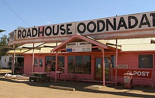
Oodnadatta is a small, remote outback town and locality in the Australian state of South Australia, located about 873 kilometres (542 mi) north of the state capital of Adelaide and 112 m above sea level.
Lasseter's Reef refers to the purported discovery, announced by Harold Bell Lasseter in 1929 and 1930, of a fabulously rich gold deposit in a remote and desolate corner of central Australia. Lasseter's accounts of the find are conflicting and its precise location remains a mystery—if it exists.
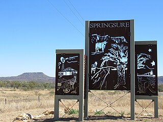
Springsure is a town and a locality in the Central Highlands Region, Queensland, Australia. It is 66 kilometres (41 mi) south of Emerald on the Gregory Highway. It is the southern terminus of the Gregory Highway and the northern terminus of the Dawson Highway. It is 765 kilometres (475 mi) northwest of Brisbane. In the 2016 census, Springsure had a population of 1,103 people.

The South West Cape is a cape located at the south-west corner of Tasmania, Australia. The cape is situated in the south-western corner of the Southwest National Park, part of the Tasmanian Wilderness World Heritage Area, approximately 140 kilometres (87 mi) southwest of Hobart in Tasmania, and about 65 kilometres (40 mi) west and a little north of the South East Cape.

King Sound is a large gulf in northern Western Australia. It expands from the mouth of the Fitzroy River, one of Australia's largest watercourses, and opens to the Indian Ocean. It is about 120 kilometres (75 mi) long, and averages about 50 kilometres (31 mi) in width. The port town of Derby lies near the mouth of the Fitzroy River on the eastern shore of King Sound. King Sound has the highest tides in Australia, and amongst the highest in the world, reaching a maximum tidal range of 11.8 metres (39 ft) at Derby. The tidal range and water dynamic were researched in 1997–1998.
Dirnaseer is a locality in the north east part of the Riverina and situated about 42 kilometres south east of Temora and 50 kilometres west of Cootamundra. At the 2006 census, Dirnaseer had a population of 170 people.
Lake Dora is a 48-hectare (120-acre) lake and also short-lived mining area of the late 1890s located in the West Coast Range of Western Tasmania, Australia. It has a surface level of 756 metres (2,480 ft) AHD .

The Kingston District Council is a local government area in the Limestone Coast, South Australia established in 1873. Kingston SE is the largest town of the district and also the seat of council.

Horsnell Gully Conservation Park is a protected area in the Australian state of South Australia in the locality of Horsnell Gully located about 9 kilometres (5.6 mi) east of the state capital of Adelaide and about 2.3 kilometres (1.4 mi) southwest of Norton Summit.
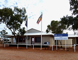
Giles Weather Station is located in Western Australia near the Northern Territory border, about 750 kilometres (470 mi) west-south-west of Alice Springs and 330 kilometres (210 mi) west of Uluru. It is the only staffed weather station within an area of about 2,500,000 square kilometres (970,000 sq mi) and is situated mid-continent and near the core of the subtropical jetstream. This means it plays an important role as a weather and climate observatory for the country, particularly eastern and southeastern Australia, and particularly for rainfall predictions. The station is on the Great Central Road and the nearest township is the Warakurna Aboriginal settlement, 5 kilometres (3 mi) North. Giles is within the Shire of Ngaanyatjarraku and is in the foothills of the Rawlinson Ranges.
The Spero River is a perennial river located in the West Coast or South West region of Tasmania, Australia.

Macumba Station, often just called Macumba, is a pastoral lease in South Australia currently operating as a cattle station.
Ketchowla Station is a pastoral lease operating as a sheep station in the Mid North region of South Australia.
Maroonah Station, often referred to as Maroonah, is a pastoral lease that operates as a sheep station.

Wirrealpa Station is a pastoral lease that operates as a sheep station and cattle station in South Australia.

Nilpena Station is a pastoral lease that operates as a sheep station in South Australia.
The Raglan Range is located in Western Tasmania, it lies east of the West Coast Range.
The District Council of Truro was a local government area in South Australia from 1876 to 1991.

Saltia is a locality in the Australian state of South Australia located on the western side of the Flinders Ranges about 279 kilometres (173 mi) north of the state capital of Adelaide and about 19 kilometres (12 mi) east of the city of Port Augusta.
References
- ↑ "Lifting the Veil from the Unknown". The Mail (Adelaide) . Vol. 15, no. 747. South Australia. 18 September 1926. p. 1. Retrieved 23 August 2016– via National Library of Australia.
- ↑ "To Erect Headstone on Lasseter's Grave". Quorn Mercury . South Australia. 1 May 1936. p. 2. Retrieved 22 August 2016– via National Library of Australia.
Coordinates: 24°50′S127°50′E / 24.833°S 127.833°E
| | This article about a location in Western Australia is a stub. You can help Wikipedia by expanding it. |