
Manitoba is a province of Canada at the longitudinal centre of the country. It is Canada's fifth-most populous province, with a population of 1,342,153 as of 2021. Manitoba has a widely varied landscape, from arctic tundra and the Hudson Bay coastline in the north to dense boreal forest, large freshwater lakes, and prairie grassland in the central and southern regions.

The Chipewyan are a Dene Indigenous Canadian people of the Athabaskan language family, whose ancestors are identified with the Taltheilei Shale archaeological tradition. They are part of the Northern Athabascan group of peoples, and hail from what is now Western Canada.

Northern Manitoba is a geographic and cultural region of the Canadian province of Manitoba. Originally encompassing a small square around the Red River Colony, the province was extended north to the 60th parallel in 1912. The region's specific boundaries vary, as "northern" communities are considered to share certain social and geographic characteristics, regardless of latitude.

The Interlake Region is an informal geographic region of the Canadian province of Manitoba that lies roughly between Lake Winnipeg and Lake Manitoba in the Canadian province of Manitoba.
Ethelbert is an unincorporated urban community in the Municipality of Ethelbert, Manitoba, Canada.
Mystery Lake is a local government district (LGD) in northern Manitoba. It surrounds the city of Thompson, although most of its territory lies to the southwest and south of the city. It is named after Mystery Lake, a lake located in the northeast section of the LGD, northeast of Thompson.
Treaty 2 was entered in to on 21 August 1872 at Manitoba House, Rupertsland, with representatives of the Queen of Great Britain and Ireland. The original Anishinaabe, who were present, constitute Treaty 2 today. It is known that many of the chiefs and leaders within the territory were at the early gathering and after the treaty was agreed to. Those who were not present were represented through Metis until they indicated where they wished their farming reserves to be established. The treaty reaffirmed the inherent rights that the Anishinaabe had prior to European contact, located where southwestern Manitoba is today and a small part of southeastern Saskatchewan.

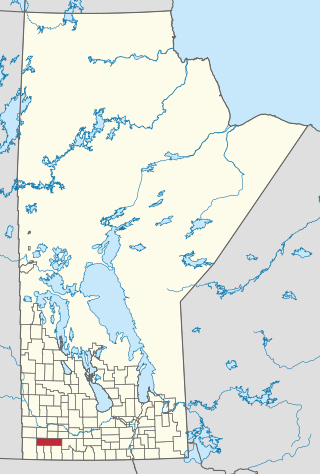
Oak Lake is an unincorporated urban community in the Rural Municipality of Sifton within the Canadian province of Manitoba that held town status prior to January 1, 2015. It is located 52 km (32 mi) west of Brandon along the Trans-Canada Highway. The lake after which it was named is in the rural municipality's western area.

The Rural Municipality of Sifton is a rural municipality (RM) in the south-west portion of the Canadian province of Manitoba.
The Municipality of Shoal Lake is a former rural municipality (RM) in the Canadian province of Manitoba. It was originally incorporated as a rural municipality on January 1, 2011. It ceased on January 1, 2015, as a result of its provincially mandated amalgamation with the RM of Strathclair to form the Rural Municipality of Yellowhead.

First Nations Transportation was a Canadian freight airline from Gimli, Manitoba.
The Municipality of Grassland is a rural municipality (RM) in the Canadian province of Manitoba.

The Rural Municipality of Prairie Lakes is a rural municipality (RM) in the Canadian province of Manitoba. The Rural Municipality of Prairies lakes surrounds most of the north end of Pelican Lake. There are several other lakes in the RM such as Grass Lake, Overend Lake, Bone Lake, Lorne Lake, Louise Lake, Lloyds Lake, Noble Lake and many more that are all much smaller than Pelican Lake.

The Rural Municipality of Yellowhead is a rural municipality (RM) in the Canadian province of Manitoba.
Clearwater Lake Provincial Park was designated a provincial park by the Government of Manitoba in 1963. The park is 593 square kilometres (229 sq mi) in size. The park is considered to be a Class II protected area under the IUCN protected area management categories.
Bell Lake Provincial Park is a provincial park on the north shore of Bell Lake in the Porcupine Provincial Forest, Manitoba, Canada. It is 4 hectares in size. It was designated as a provincial park in 1974.
Lake St. George Caves Ecological Reserve is an ecological reserve located west of Lake Winnipeg, Manitoba, Canada. It was established in 1997 under the Manitoba Ecological Reserves Act. It is .49 square kilometres (0.19 sq mi) in size.
Lake Winnipegosis Salt Flats Ecological Reserve is an ecological reserve located on the west of Lake Winnipegosis, Manitoba, Canada. It was established in 1992 under the Manitoba Ecological Reserves Act. It is 47.25 square kilometres (18.24 sq mi) in size.

