Putucusi

Last updated
Putucusi
Machu Picchu LB11.JPG
Putucusi (center-left) behind the ruins of Machu Picchu
Highest point
Elevation 2,560 m (8,400 ft)
Coordinates 13°09′20″S72°32′10″W / 13.15556°S 72.53611°W / -13.15556; -72.53611
Geography
Peru physical map.svg
Red triangle with thick white border.svg
Putucusi
Peru
Location Peru, Cusco Region
Parent range Andes

Putucusi (possibly from Quechua phutu bud, -q a suffix, k'usi a cucurbit species, a small zucchini or Cucurbita pepo , [1] "budding zucchini (or Cucurbita pepo)") is a round-shaped mountain located on the opposite side (northeast) of the Urubamba River to Machu Picchu in the Cusco Region of Peru. Reaching approximately 2,560 metres (8,400 ft) above sea level at its peak, the mountain offers epic views of Machu Picchu and the surrounding Urubamba River valley.

Contents

"Putu Cusi" has been described by Quechua-speaking guides as "Happy Mountain". According to Glosbe Glosbe online Quechua-English dictionary, "Kusi" means "happy", and "Putuq" translates to "trapezoid". As the feature could be seen as a trapezoidal mountain that would align with this translation. It is important to recognize that Quechua has several dialects.

Putucusi, Machu Picchu ("old peak" in Quechua) and Huayna Picchu ("young peak") are considered apus or holy mountains by the local Quechua people.

Climbing

The view of Machu Picchu from the summit requires a 1.5-hour trek up the mountain, with approximately 1,700 wood and rock steps. A recently discovered Inca Trail, the path lies just 10 minutes west of Aguas Calientes following the train tracks along the Urubamba River. The entrance is free.

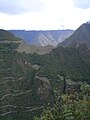
The first half of the journey is jungle trail, and involves several vertical wooden ladders, the largest of which scales over 100 feet (30 m). The second half presents views of Aguas Calientes and the Urubamba River valley, as the trail ascends the eastern face of Putucusi in switchback fashion. The trail passes through native flora including pisonayes, q'eofias, alisos, puya palm trees, ferns and more than 90 species of orchids.

In spring 2011, floods wiped out the vertical ladder section of the climb, making an ascent impossible without professional climbing gear, but by August 2012, all the ladders had been replaced.

Updated to June 2016, the access to the trail has been restricted and forbidden, due to the lack of maintenance of the path. All the ladders are indeed destroyed and it's impossible and extremely dangerous to climb up without professional climbing equipment. Local rangers are monitoring the area and the entrance to avoid unauthorized accesses and prevent accidents.

Images

See also

Related Research Articles

<span class="mw-page-title-main">Machu Picchu</span> 15th-century Inca citadel in Peru

Machu Picchu is a 15th-century Inca citadel located in the Eastern Cordillera of southern Peru on a 2,430-meter (7,970 ft) mountain ridge. Often referred to as the "Lost City of the Incas", it is the most familiar icon of the Inca Empire. It is located in the Machupicchu District within Urubamba Province above the Sacred Valley, which is 80 kilometers (50 mi) northwest of Cusco. The Urubamba River flows past it, cutting through the Cordillera and creating a canyon with a tropical mountain climate. In reference to the site's name, for most English or Spanish speakers, the first 'c' in Picchu is silent. In English, the name is pronounced MAH-choo PEE-choo or MATCH-oo PEAK-choo, in Spanish as or, and in Quechua as.

<span class="mw-page-title-main">Sacred Valley</span> Valley in the Andes Mountains of Peru

The Sacred Valley of the Incas, or the Urubamba Valley, is a valley in the Andes of Peru, north of the Inca capital of Cusco. It is located in the present-day Peruvian region of Cusco. In colonial documents it was referred to as the "Valley of Yucay." The Sacred Valley was incorporated slowly into the incipient Inca Empire during the period from 1000 to 1400.

<span class="mw-page-title-main">Aguas Calientes, Peru</span> Town in Cusco, Peru

Machupicchu or Machupicchu Pueblo, also known as Aguas Calientes, is a location in Peru situated in the Cusco Region, Urubamba Province. It is the seat of the Machupicchu District. Machupicchu lies at the Vilcanota River. It is the closest access point to the historical site of Machu Picchu which is 6 kilometres (3.7 mi) away or about a 90-minute walk. There are many hotels and restaurants for tourists, as well as natural hot baths which gave the town its colloquial Spanish name.

<span class="mw-page-title-main">Pongo de Mainique</span> Feature of the Urubamba River, Peru

The Pongo de Mainique is a water gap (canyon) of the Urubamba River in Peru. Inside the water gap, the river is constricted to a width of 45 metres (50 yd). The Pongo de Mainique is 3 kilometres (2 mi) long. The elevation of the river is approximately 450 metres (1,480 ft). The steep cliffs on each side of the river rise sharply to mountains with elevations of more than 1,200 metres (3,900 ft).

<span class="mw-page-title-main">Huayna Picchu</span> Archaeological site in Peru

Huayna Picchu, Quechua: Wayna Pikchu, is a mountain in Peru around which the Urubamba River bends. It is located in the Cusco Region, Urubamba Province, Machupicchu District. It rises over Machu Picchu, the so-called lost city of the Incas. The Incas built a trail up the side of the Huayna Picchu and built temples and terraces on its top. The peak of Huayna Picchu is 2,693 metres (8,835 ft) above sea level, or about 260 metres (850 ft) higher than Machu Picchu.

<span class="mw-page-title-main">PeruRail</span> Peruvian rail service

PeruRail is a railway operator providing tourist, freight, and charter services in southern Peru. It was founded in 1999 by two Peruvian entrepreneurs and the British company Sea Containers.

<span class="mw-page-title-main">Inca Bridge</span> Bridge providing access to Machu Picchu in Peru

The Inca Bridge or Inka Bridge refers to one of two places related to access to Machu Picchu, in Peru.

<span class="mw-page-title-main">Choquequirao</span> Archaeological site in Peru

Choquequirao is an Incan site in southern Peru, similar in structure and architecture to Machu Picchu. The ruins are buildings and terraces at levels above and below Sunch'u Pata, the truncated hill top. The hilltop was anciently leveled and ringed with stones to create a 30 by 50 m platform.

<span class="mw-page-title-main">Salcantay</span> Mountain in Peru

Salcantay, Salkantay or Sallqantay is the highest peak in the Vilcabamba mountain range, part of the Peruvian Andes. It is located in the Cusco Region, about 60 km (40 mi) west-northwest of the city of Cusco. It is the 38th-highest peak in the Andes and the twelfth-highest in Peru. However, as a range highpoint in deeply incised terrain, it is the second most topographically prominent peak in the country, after Huascarán.

<span class="mw-page-title-main">Urubamba Province</span> Province in Cusco, Peru

Urubamba Province is one of thirteen provinces in the Cusco Region in the southern highlands of Peru.

<span class="mw-page-title-main">Lares trek</span> High-altitude hike in Peru near Machu Picchu

The Lares trek is a two- or three-day high-altitude hike in Cusco, Peru, starting near the village Lares, approximately 40 mi (64 km) north of Cusco and 35 mi (56 km) east of Machu Picchu. The Lares Valley lies in the east of the Urubamba mountain range, traversing part of the Sacred Valley. Reaching the start of the trek requires a bus or van trip of approximately five hours from the village of Lares. The trek route transverses typical Peruvian Andean mountain areas.

<span class="mw-page-title-main">Pakaymayu</span> River in Peru

The Pakaymayu or Paqaymayu is a river in Peru located in the Cusco Region, Urubamba Province, Machupicchu District. It is a left tributary of the Willkanuta River.

<span class="mw-page-title-main">Inti Punku</span> Archaeological site in Peru

Inti Punku or Intipunku is an archaeological site in the Cusco Region of Peru that was once a fortress of the sacred city, Machu Picchu. It is now also the name of the final section of the Incan Trail between the Sun Gate complex and the city of Machu Picchu. It was believed that the steps were a control gate for those who enter and exited the Sanctuary.

<span class="mw-page-title-main">Inca Trail to Machu Picchu</span> Ancient trail in Peru

The Inca Trail to Machu Picchu is a hiking trail in Peru that terminates at Machu Picchu. It consists of three overlapping trails: Mollepata, Classic, and One Day. Mollepata is the longest of the three routes with the highest mountain pass and intersects with the Classic route before crossing Warmiwañusqa. Located in the Andes mountain range, the trail passes through several types of Andean environments including cloud forest and alpine tundra. Settlements, tunnels, and many Incan ruins are located along the trail before ending the terminus at the Sun Gate on Machu Picchu mountain. The two longer routes require an ascent to beyond 4,200 metres (13,800 ft) above sea level, which can result in altitude sickness.

<span class="mw-page-title-main">Cusichaca River</span> River in Peru

Cusichaca River, is a river in Peru located in the Cusco Region, Urubamba Province, on the border of the districts Machupicchu and Ollantaytambo. Its waters flow to the Vilcanota River.

<span class="mw-page-title-main">Patallacta</span> Archaeological site in Peru

Patallacta, Llactapata or Q'ente Marka is an archaeological site in Peru located in the Cusco Region, Urubamba Province, Machupicchu District. It is situated southeast of the site Machu Picchu, at the confluence of the rivers Cusichaca and Vilcanota on a mountain named Patallacta.

<span class="mw-page-title-main">Intihuatana, Urubamba</span> Archaeological site in Peru

Intihuatana at the archaeological site of Machu Picchu is a notable ritual stone associated with the astronomic clock or calendar of the Inca in South America. Machu Picchu was thought to have been built c. 1450 by the Sapa Inca Pachacuti as a country estate. In the late 16th century, the Viceroy Francisco de Toledo and the clergy destroyed those Intihuatana which they could find. They did so as they believed that the Incas' religion was a blasphemy and the religious significance of the Intihuatana could be a political liability. The Intihuatana of Machu Picchu was found intact by Bingham in 1911, indicating that the Spanish conquerors had not found it. Intihuatana was damaged on September 8, 2000 when a crane being used in an ad shoot toppled over and chipped off a piece of the granite.

<span class="mw-page-title-main">Runkuraqay</span> Archaeological site in Peru

Runkuraqay or Runku Raqay is an archaeological site on a mountain of the same name in Peru located in the Cusco Region, Urubamba Province, Machupicchu District. It is situated southeast of the archaeological site Machu Picchu and south of the Vilcanota river. The ruins lie on the southern slope of the mountain Runkuraqay near the Runkuraqay pass, northeast of the archaeological site Sayacmarca and southeast of the site Qunchamarka.

<span class="mw-page-title-main">Qunchamarka</span> Archaeological site in Peru

Qunchamarka is an archaeological site in Peru located in the Cusco Region, Urubamba Province, Machupicchu District, southwest of the mountain Runkuraqay. It lies between the archaeological sites Sayaqmarka and Phuyupatamarka on the Inca Trail to Machu Picchu.

Belmond Hiram Bingham is a luxury train operating day return trips from Poroy station outside Cusco to Aguas Calientes, the station for Machu Picchu in Peru.

References

  1. Diccionario Quechua - Español - Quechua, Academía Mayor de la Lengua Quechua, Gobierno Regional Cusco, Cusco 2005: phutu - s. Ramillete de flores.k'usi - s. Bot. (Cucúrbita sp.) Calabacín pequeño. Planta de la familia de las cucurbitáceas, utilizada en la alimentación, andina.