Pwll-coch

Last updated

Pwll-coch is an area part of the district of Canton in Cardiff, Wales. It was formerly a separate hamlet in the parish of Llandaff near Cardiff. It was located on the junction of Windway Road and the main road from Cardiff to Ely (the modern A4161 at Cowbridge Road East), a short distance from Ely Bridge.

Contents

Name

Ty Pwll Coch public house sign Ty Pwll Coch public house sign.jpg
Tŷ Pwll Coch public house sign

The name is from the Welsh 'pwll coch' which means 'red pool'. The 'Pwll Coch' was originally a pool in the river Ely that supposedly filled with blood following the Battle of St Fagans in 1648. [1] Due to straightening of the river's course (the 'new cut') the pool no longer exists. Ysgol Gymraeg Pwll Coch, a Welsh-medium primary school in the nearby Leckwith district of Canton, is also named after the pool.

History

Until the late nineteenth century, Pwll-coch was part of the township of Ely. It was located on the western edge of Ely Common (formerly Llandaff Common), which roughly corresponds to the modern Victoria Park area of Canton. Pwll-coch was included in Canton when the latter was incorporated into Cardiff in 1875. The rest of Ely was not included within the city boundary until 1922.

People, commerce and industry

Chest tombs of Thomas and Jonas families at Llandaff Chest tombs of Thomas and Jonas families at Llandaff.jpg
Chest tombs of Thomas and Jonas families at Llandaff

Until the middle of the nineteenth century, Pwll-coch consisted in the main of a farm, a public house (Tŷ Pwll Coch, which closed in 2012) and some cottages. There was also a workshop used by the Jonas family of Pwll-coch, who were well known as carpenters and wheelwrights. [2] Elizabeth Jonas (1806–1865) was a noted businesswoman and supporter of Methodism in Ely and Cardiff. She married John Thomas (1804–1842), a brewer from across the river in Ely. After his early death she continued to operate the Castle Brewery in Cardiff for over twenty years (it was later taken over by Hancocks Brewery). [3] She was a generous donor to the Welsh-speaking Methodist chapels in Ely and Cardiff. [4] Elizabeth is buried with her husband and children at Llandaff Cathedral; the Jonas family tomb is close by. [5]

In 1865 a paper mill opened on land between the old Pwll Coch pool on the river Ely and the hamlet of Pwll-coch. Located between the river and the South Wales Railway, the Ely Paper Company was liquidated in 1875 and taken over by Samuel Evans and Thomas Owen (uncle and half-brother of Liverpool businessman Owen Owen). [6] Following Evans' death the company was reformed as Thomas Owen & Co. Paper manufacturing continued at the site until 2000. [7] A large housing estate is currently being built on the old mill site. [8]

During the 1870s Stephen Treseder (1834–1909) opened a nursery at Pwll-coch. [9] Originally known as the Ely Road Nursery, it was later called Pwll Coch Nurseries. The nursery supplied plants for many local estates, including that of the Bute family at Cardiff Castle. [10] The nursery also gave its name to the Pwll Coch Dahlia. [11]

Related Research Articles

<span class="mw-page-title-main">Llandaff</span> District and community of Cardiff, Wales

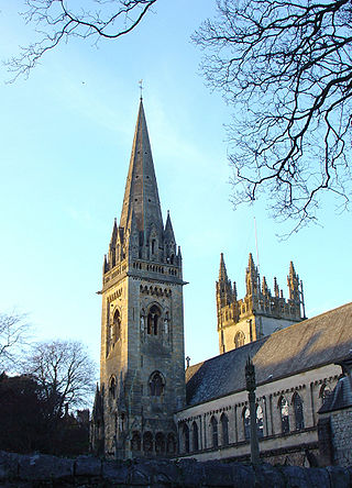
Llandaff is a district, community and coterminous electoral ward in the north of Cardiff, capital of Wales. It was incorporated into the city in 1922. It is the seat of the Bishop of Llandaff, whose diocese within the Church in Wales covers the most populous area of Wales.

<span class="mw-page-title-main">Radyr</span> Suburb of Cardiff, Wales

Radyr is an outer suburb of Cardiff, about 4 miles (6.4 km) northwest of Cardiff city centre. Radyr is part of Radyr and Morganstown Community, for which the 2011 Census recorded a population of 6,417.

<span class="mw-page-title-main">Pontcanna</span> District and community in Cardiff, Wales

Pontcanna is a district and community in the city of Cardiff, Wales. It is located a short distance to the west of the city centre, and its borders are approximately indicated by Western Avenue, the River Taff, Cowbridge Road East, Llandaff Road and Cardiff Road.

<span class="mw-page-title-main">Taff Trail</span> Walking and cycling track in South Wales

The Taff Trail is a popular walking and cycle path that runs for 55 miles (89 km) between Cardiff Bay and Brecon in Wales. It is so named because it follows the course of the River Taff. Along much of its length, it follows the National Cycle Network Route 8 that continues to Holyhead, and is substantially off-road.

<span class="mw-page-title-main">Whitchurch, Cardiff</span> Suburb and community in Cardiff, Wales

Whitchurch is a suburb and community in the north of Cardiff, capital of Wales. It is approximately 3 miles north of the centre of the city on the A470 road and A4054 road. It falls within the Whitchurch & Tongwynlais ward. The population of the community in 2011 was 14,267.

<span class="mw-page-title-main">Canton, Cardiff</span> District and community in Cardiff, Wales

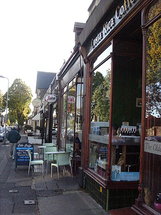
Canton is an inner-city district and community in the west of Cardiff, capital of Wales, lying 2 miles (3.2 km) west of the city's civic centre. Canton is one of the most ethnically diverse of Cardiff's suburbs, with a significant Pakistani and Indian population. The total population of Canton increased to 14,304 at the 2011 census. It is also the most Welsh-speaking district of central Cardiff, with 19.1% of the population speaking Welsh.

<span class="mw-page-title-main">Grangetown, Cardiff</span> District and community in Cardiff, Wales

Grangetown is a district and community in the south of Cardiff, capital of Wales. It is one of the largest districts in the south of the city and is bordered by Riverside, Canton and Butetown. The River Taff winds its way through the area. Adjacent to the city's Cardiff Bay area, Grangetown is experiencing a period of gentrification and improvements in its infrastructure. Its population as of 2011 was 19,385 in 8,261 households. One of the "five towns of Cardiff", the others are Butetown, Crockherbtown, Newtown and Temperance Town.

<span class="mw-page-title-main">Fairwater, Cardiff</span> District and community in Cardiff, Wales

Fairwater is a district and community in the west of Cardiff, capital of Wales. It is located a few miles from Culverhouse Cross which connects Cardiff to the M4 motorway. The population taken at the 2011 census was 12,981.

<span class="mw-page-title-main">Howell's School, Llandaff</span> Independent day school in Cardiff, Wales

Howell's School is an independent day school for girls in Llandaff, a district in northern Cardiff, Wales. It consists of a nursery, infants, junior, senior school and a sixth form. The sixth form became coeducational in September 2005 and was renamed Howell's Co-ed College.

<span class="mw-page-title-main">Bretton, Flintshire</span> Human settlement in Wales

Bretton is a village in Flintshire, Wales. It is located to the west of the city of Chester, near the border with Cheshire, England. Along with the nearby village of Broughton, the population was 5,791 at the 2001 Census.

<span class="mw-page-title-main">Broadcasting House, Cardiff</span> Building in north Cardiff, Wales

Broadcasting House was the headquarters of BBC Cymru Wales' radio, television and online services, situated in north Cardiff. The purpose-built facility opened in 1966 and consists of three blocks containing studios, offices and technical facilities. In 2020 the BBC moved out, transferring to BBC Cymru Wales New Broadcasting House in Central Square, Cardiff. The building was demolished in 2021 to 2022, with the site to be used for housing.

<span class="mw-page-title-main">John Prichard</span> British architect (1817–1886)

John Prichard was a Welsh architect in the neo-Gothic style. As diocesan architect of Llandaff, he was involved in the building or restoration of many churches in south Wales.

<span class="mw-page-title-main">Llandaff Fields</span> Multi-use park and playings fields in Cardiff, Wales

Llandaff Fields is a large parkland spanning parts of central and northern Cardiff, Wales.

<span class="mw-page-title-main">Architecture of Cardiff</span> Overview of the architecture in the capital city of Wales

Architecture in Cardiff, the capital city of Wales, dates from Norman times to the present day. Its urban fabric is largely Victorian and later, reflecting Cardiff's rise to prosperity as a major coal port in the 19th century. No single building style is associated with Cardiff, but the city centre retains several 19th and early 20th century shopping arcades.

<span class="mw-page-title-main">Ysgol Gymraeg Pwll Coch</span> Welsh-medium state school in Cardiff, Wales

Ysgol Gymraeg Pwll Coch is a large Welsh-medium primary school in the Leckwith area of western Cardiff, in Wales.

Canton is the name of an electoral ward in the west of the city of Cardiff, Wales, which covers part of its namesake community, Canton. The ward elects three county councillors to the County Council of the City and County of Cardiff.

<span class="mw-page-title-main">Sanatorium Park</span> Public park in Cardiff

Sanatorium Park is a public park in the Leckwith district of western Cardiff, Wales. It includes open green space, wildflower hedgerows, two play areas, and a football goal with a half basketball court.

References

  1. 'Schedule of place names: N – R', Cardiff Records: volume 5 (1905), pp. 394–413. URL: http://www.british-history.ac.uk/report.aspx?compid=48205.
  2. 'Glamorganshire: To be sold by auction', The Cambrian , 30 November 1839.
  3. Lesley Richmond and Alison Turton (ed.),The Brewing Industry: A Guide to Historical Records, (Manchester, 1990), p. 167.
  4. T. J. Hopkins, 'Elizabeth Thomas, Glyn Teg Hall, Ely', Bathafarn, 20 (1965), 66–68.
  5. 'Memorial inscriptions: Llandaff Cathedral', Cardiff Records: volume 3 (1901), pp. 553–580. URL: http://www.british-history.ac.uk/report.aspx?compid=48178.
  6. Alun Eurig Davies, 'Paper-mills and paper-makers in Wales, 1700–1900', National Library of Wales Journal, 15.1 (1967), 1–30.
  7. Coflein: Ely Paper Mills; Ely Mills, Ely Paper Works, Ely, Cardiff.
  8. "Home". themill-canton.co.uk.
  9. Ray Desmond, Dictionary Of British And Irish Botantists And Horticulturalists (London, 1994), p. 691.
  10. 'Rural notes', The Leeds Mercury, 25 October 1890.
  11. World Dahlia Directory.

Coordinates: 51°29′02″N3°13′26″W / 51.48389°N 3.22389°W / 51.48389; -3.22389