
The Geography of Kenya is diverse, varying amongst its 47 counties. Kenya has a coastline on the Indian Ocean, which contains swamps of East African mangroves. Inland are broad plains and numerous hills. Kenya borders South Sudan to the northwest, Uganda to the west, Somalia to the east, Tanzania to the south, and Ethiopia to the north. Kenya currently faces border disputes with South Sudan over the Ilemi Triangle and with Somalia over Jubbaland where, if the Somalian Government gives it up, it could be a new part of Kenya, which would bring the total land area of Kenya to approximately 692,939 km2.

Tanzania comprises many lakes, national parks, and Africa's highest point, Mount Kilimanjaro. Northeast Tanzania is mountainous, while the central area is part of a large plateau covered in grasslands. The country also contains the southern portion of Lake Victoria on its northern border with Uganda and Kenya.
The 49th parallel north is a circle of latitude that is 49° north of Earth's equator. It crosses Europe, Asia, the Pacific Ocean, North America, and the Atlantic Ocean.

Avalon is a federal electoral district on Newfoundland Island in Newfoundland and Labrador, Canada. It has been represented in the House of Commons of Canada since 2004.

Bonavista—Gander—Grand Falls—Windsor was a federal electoral district in Newfoundland and Labrador, Canada, that was represented in the House of Commons of Canada from 2004 until 2015.

Humber—St. Barbe—Baie Verte was a federal electoral district in Newfoundland and Labrador, Canada, that was represented in the House of Commons of Canada from 1988 to 2015.
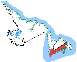
Random—Burin—St. George's was a federal electoral district in Newfoundland and Labrador, Canada, that was represented in the House of Commons of Canada from 2004 to 2015.

Dunnet Head is a headland in Highland, on the north coast of Scotland. Dunnet Head includes the most northerly point of both mainland Scotland and the island of Great Britain.
Parkdale was a Canadian federal electoral district represented in the House of Commons of Canada from 1917 to 1979. It included the community of Parkdale in the western part of Toronto, Ontario. It was created in 1914 from Toronto West, and continued to exist until 1976 when most of it was merged into Parkdale—High Park with some sections into Trinity.

Nepean is a federal electoral district in Ontario, Canada that was represented in the House of Commons of Canada from 1988 to 1997, and was reinstated during the 2012 electoral redistribution.

Sault Ste. Marie is a federal electoral district in Ontario, Canada, that has been represented in the House of Commons of Canada since 1968.

The Ilemi Triangle, sometimes called only Ilemi, is a disputed area in East Africa, claimed by both Kenya and South Sudan. Arbitrarily defined, it measures about 11,000 square kilometres (4,200 sq mi). The territory is claimed by South Sudan and Kenya. The territory also borders Ethiopia and, despite use and trespass into the triangle by border tribes from within Ethiopia, the Ethiopian government has not made any official claim on the area, instead agreeing that the land was Sudanese territory in the 1902, 1907, and 1972 treaties.
The Chittenden-3-2 Representative District is a one-member state Representative district in the U.S. state of Vermont. It is one of the 108 one or two member districts into which the state was divided by the redistricting and reapportionment plan developed by the Vermont General Assembly following the 2000 U.S. Census. The plan applies to legislatures elected in 2002, 2004, 2006, 2008, and 2010. A new plan will be developed in 2012 following the 2010 U.S. Census.

The geography of New York varies widely across the state. Most of New York is dominated by farms, forests, rivers, mountains, and lakes. New York's Adirondack Park is larger than any U.S. National Park in the contiguous United States. Niagara Falls, on the Niagara River as it flows from Lake Erie to Lake Ontario, is a popular attraction. The Hudson River begins near Lake Tear of the Clouds and flows south through the eastern part of the state without draining lakes George or Champlain. Lake George empties at its north end into Lake Champlain, whose northern end extends into Canada, where it drains into the Richelieu River and then the St. Lawrence. Four of New York City's five boroughs are on the three islands at the mouth of the Hudson River: Manhattan Island, Staten Island, and Brooklyn and Queens on Long Island.
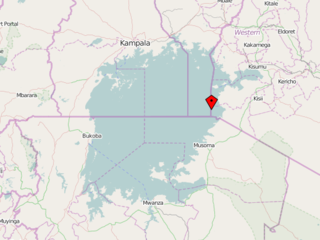
Migingo is a 2,000-square-metre island in Kenya on Lake Victoria. The island was the center of a low-level territorial dispute between Kenya and Uganda and is extremely densely populated. Migingo is a source of fish to the Kenyan and Ugandan fishermen.

The geography of South Sudan describes the physical features of South Sudan, a country in East Africa. South Sudan is a landlocked country and borders – clockwise – Sudan from the north, Ethiopia from the east, Kenya, Uganda and the Democratic Republic of the Congo from the south and the Central African Republic from the west.

Long Range Mountains is a federal electoral district in the Canadian province of Newfoundland and Labrador. It covers the entirety the west coast of the island of Newfoundland.

Queensland is the north-eastern state of Australia and has land borders with three other Australian states and territories: New South Wales, South Australia and Northern Territory. To the north of Queensland is the Torres Strait separating the Australian mainland from Papua New Guinea. To the east of Queensland is the Coral Sea, part of the Pacific Ocean. There are many islands off the Queensland coast which form part of the state of Queensland.
Sumba Island is an island in Lake Victoria that is divided between Kenya and Uganda. It is located in the administrative area of Busia County in the western part of the country, 400 km west of the capital Nairobi.
